
|
|
SUBSIM: The Web's #1 resource for all submarine & naval simulations since 1997
|
SUBSIM: The Web's #1 resource for all submarine & naval simulations since 1997 |
|
|
 03-30-09, 10:02 AM
|
#1 |
|
Watch
 Join Date: Apr 2007
Location: USA
Posts: 30
Downloads: 50
Uploads: 0
|
Here is a map I found in an old Time-Life book (The Battle of the Atlantic, page 98). What I found interesting was the large amount of activity that occurred in the Caribbean. I was pretty unaware of this fact.The dark red areas are where the most number of sinkings occurred. White lines are Principal routes, gray lines are Secondary routes, red color-heaviest sinking areas, pink color-large sinking losses. Sorry for the poor reproduction as I had to take a pic of it. I thought I would share with those who would find it as interesting as I did.
Here's the caption included with the map: "The Battle of the Atlantic centered around the shipping routes shown here. Areas where the greatest numbers of ships were sunk are indicated in red, with the heaviest losses in deep red. The U-boats began their attacks in the Western Approaches, near Britian, and later divided their effort between the Greenland area and the coast of Africa. Next the East Coast of the United States became the main target region. Then the subs moved down to the Caribbean, before returning to the area west of Britain." 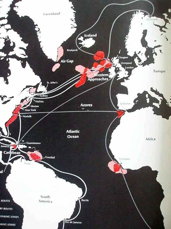
__________________

Last edited by helibobber; 03-30-09 at 04:50 PM. |

|

|
|
03-30-09, 10:16 AM
|
#2 |
|
Weps
 Join Date: Oct 2008
Location: Veria, Greece
Posts: 365
Downloads: 44
Uploads: 0
|
Intresting map!
Do you know if that book is distributed in other languages too? 
|
|
|
|
|
03-30-09, 10:49 AM
|
#3 | |
|
Watch
Join Date: Apr 2007
Location: USA
Posts: 30
Downloads: 50
Uploads: 0
|
Quote:
__________________
|
|
|
|
|
|
03-30-09, 11:56 AM
|
#4 |
|
Silent Hunter
 Join Date: Aug 2005
Location: Figueira da Foz, Portugal
Posts: 4,515
Downloads: 110
Uploads: 0
|
An nice book with maps of the merchant sinkings by u-boats plus the u-boats lost, divided by years (ex: september 1939 - may 1940, and so one) are in "The Illustrated History of the Third Reich" by Chris Bishop & David Jordan. It's from 2005, Amber Books Ltd.
|
|
|
|
|
03-30-09, 12:29 PM
|
#5 | |
|
Chief of the Boat

 Join Date: Feb 2006
Location: 250 metres below the surface
Posts: 190,473
Downloads: 63
Uploads: 13


|
Quote:
A great book series I also collected and passed on to a friend last July 
__________________
Wise men speak because they have something to say; Fools because they have to say something.
Oh my God, not again!!  |
|
|
|
|
|
03-30-09, 02:23 PM
|
#6 | |
|
Captain
 Join Date: Feb 2009
Location: Drinking a cold one in Davey Jone's locker.
Posts: 487
Downloads: 26
Uploads: 0
|
I didn't realize there were so many sinkings just outside of Gibralter. Too close to the aircover there for my taste.

__________________
Quote:
 |
|
|
|
|
|
03-30-09, 05:49 PM
|
#7 |
|
Weps
Join Date: Feb 2009
Location: Wilhelmshaven Local Pub
Posts: 361
Downloads: 2
Uploads: 0
|
Interesting info. I'm surprised nothing is highlight southwest of Ireland. In the games I play, seems like there are always juicy tankers or convoys around BE39 or so.
__________________
NYGM3.2 + Tonnage War Minefield________IABLShipsRezonedFinal Hitman Optics & Compass_______________Thomsen's Sound Mod v3 100% Realism DID + No God's Eye View____SH3 Commander Crew Rotation  |
|
|
|
 |
|
|


 Hybrid Mode
