
|
|
SUBSIM: The Web's #1 resource for all submarine & naval simulations since 1997
|
SUBSIM: The Web's #1 resource for all submarine & naval simulations since 1997 |
 10-20-05, 01:15 PM
|
#31 |
|
Engineer
 Join Date: Apr 2005
Posts: 206
Downloads: 0
Uploads: 0
|
Hmm, we could also implement a lot of Text around the Map!
Just for testing a little bit around.... I included a field with Rubinis milccow dates.... Because we have a lot of free unused space around the big map! Like this screens u will see.  
__________________
Wolves are waiting for the night to come.... 
|

|

|
|
10-20-05, 01:21 PM
|
#32 |
|
Admiral
 Join Date: Nov 2004
Location: Silver Spring, MD, USA (but still a Yorkshireman at heart - tha can allus tell a Yorkshireman...)
Posts: 2,497
Downloads: 0
Uploads: 0
|
I was thinking more of smaller sea areas such as Dogger Bank, Rockall, etc. Something that we can put in a log report.
__________________
"More mysterious. Yeah. I'll just try to think, 'Where the hell's the whiskey?'" - Bob Harris, Lost in Translation. "Anyrooad up, ah'll si thi" - Missen. |
|
|
|
|
10-20-05, 02:20 PM
|
#33 |
|
Ocean Warrior
 Join Date: May 2005
Location: São Paulo Brazil
Posts: 2,728
Downloads: 132
Uploads: 0
|
FLB,
Great progress!  Some suggestions: -Use the map with the convoy routes, -The big oceans and the small ones too (as correctly suggest by Beery) with different font size, -I think that you don't have to put the milk cow info because you will limit the usage for the peoples who don't like the mod. And we have the F1 help screen... -More info about convoys like the map into the "box" will be great. -The allied air coverage are useless because the mods already overwrite that stock info and it is year dependent. I guess that we want a realistic map, no? I think that is all. Someone have more suggestions? Rubini. |
|
|
|
|
10-20-05, 03:58 PM
|
#34 |
|
Watch
 Join Date: Apr 2005
Location: Germany
Posts: 27
Downloads: 14
Uploads: 0
|
Try to insert the convoy routes on the map.
That will be cool cuz i lost my Silent Hunter III map.  
__________________
Torpedos- LOS! |
|
|
|
|
10-20-05, 05:00 PM
|
#35 |
|
Chief
 Join Date: Oct 2005
Posts: 312
Downloads: 0
Uploads: 0
|
Also the large fjords in the norwegian area should be included and the names of important islands like Iceland the Bear island.....
the Denmark Straight.... etc |
|
|
|
|
10-21-05, 06:00 AM
|
#36 |
|
Engineer
Join Date: Apr 2005
Posts: 206
Downloads: 0
Uploads: 0
|
Ok, i will do my best this weekend....
found a nice page for Oceans..... http://maproom.lighthouse-foundation.org/de/ Anybody knows tipps or Cards of Land or world?
__________________
Wolves are waiting for the night to come....
|
|
|
|
|
10-21-05, 07:13 AM
|
#37 |
|
Engineer
Join Date: Apr 2005
Posts: 206
Downloads: 0
Uploads: 0
|
Ok, no way for Minefields etc. in the highest zoomlevels!
Can`t zoom so much in in PHP. Smallest fonts are unreadable in high zooms I will do first the most sea names..... a lot of work now..... Problem is, for the high zoom i need to edit the big 222 MB Map. Problem ther. i can`t zoom so much in or write with the smallest fonts like 2 or 4, because u can`t read anything because it is very unsharp. Can i work in Sheppards Convoy Routes Map? Because there are the Routes already inside.... That will all be seen in the last 3 Zoomlevels... maybe hard to read ....
__________________
Wolves are waiting for the night to come....
|
|
|
|
|
10-21-05, 07:23 AM
|
#38 |
|
Engineer
Join Date: Apr 2005
Posts: 206
Downloads: 0
Uploads: 0
|
Another question:
Anybody know the Letters from that time? Which font was used in the Second WW on Maps or Cards?
__________________
Wolves are waiting for the night to come....
|
|
|
|
|
10-21-05, 08:20 AM
|
#39 | |
|
Über Mom
 Join Date: May 2005
Location: Jerusalem, Israel
Posts: 6,147
Downloads: 5
Uploads: 0
|
Quote:
__________________
    "Victory will come to us from the wombs of our women." - Houari Boumedienne, President of Algeria, Speech before the UN, 1974 |
|
|
|
|
|
10-21-05, 12:23 PM
|
#40 |
|
Engineer
Join Date: Apr 2005
Posts: 206
Downloads: 0
Uploads: 0
|
Ok!
here a version with included Seanames..... I used the ConvoyMap Map! Here a screenshot:  Here the File for download so u can search the names and take a look on it: http://rapidshare.de/files/6571902/RAWKonvoyMap.7z.html There are a lot of Seanames now inside.... It is only the small Map, so it is only visible in the 3 last Zoomlevels! Don`t know if u meaned that thing.... :hmm: Was enough work with testing-.......  Greetings Sale
__________________
Wolves are waiting for the night to come....
|
|
|
|
|
10-21-05, 12:25 PM
|
#41 |
|
Engineer
Join Date: Apr 2005
Posts: 206
Downloads: 0
Uploads: 0
|
Hmm, have to adjust Nordsee and Ostsee a little bit better.....
For the Map up for Download! You can read the names at best, when u are at the third Zoomlevel! Would like to hear if somebody find all Seanames i have included... Sale
__________________
Wolves are waiting for the night to come....
|
|
|
|
|
10-21-05, 12:36 PM
|
#42 |
|
Ocean Warrior
Join Date: May 2005
Location: São Paulo Brazil
Posts: 2,728
Downloads: 132
Uploads: 0
|
Great again FLB!
I'm at my work now. When i go back to my house I will download and post a feedback! Greetings, Rubini. |
|
|
|
|
10-21-05, 01:12 PM
|
#43 |
|
Admiral
Join Date: Nov 2004
Location: Silver Spring, MD, USA (but still a Yorkshireman at heart - tha can allus tell a Yorkshireman...)
Posts: 2,497
Downloads: 0
Uploads: 0
|
How about something like this:
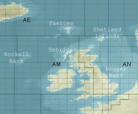 I don't know the German translations, but what's important to me is not really the seas and oceans - I pretty much know whether I'm in the North Sea or the Atlantic. What I like to be aware of is the geography around me - if I'm somewhere west of the British Isles and the sea gets shallow in the area I want to know whether that's Rockall Bank or the Faeroe bank. I also want to know whether the islands around me are the Faeroes or the Shetlands. I wish I could do the work myself, but Photoshop LE doesn't let me play with layers (the image just appears black in Photoshop). Maybe I should go out and buy a program that supports layer tweaking.
__________________
"More mysterious. Yeah. I'll just try to think, 'Where the hell's the whiskey?'" - Bob Harris, Lost in Translation. "Anyrooad up, ah'll si thi" - Missen. |
|
|
|
|
10-21-05, 01:49 PM
|
#44 | |
|
Admiral
Join Date: Nov 2004
Location: Silver Spring, MD, USA (but still a Yorkshireman at heart - tha can allus tell a Yorkshireman...)
Posts: 2,497
Downloads: 0
Uploads: 0
|
Quote:
__________________
"More mysterious. Yeah. I'll just try to think, 'Where the hell's the whiskey?'" - Bob Harris, Lost in Translation. "Anyrooad up, ah'll si thi" - Missen. |
|
|
|
|
|
10-21-05, 01:57 PM
|
#45 |
|
Engineer
Join Date: Apr 2005
Posts: 206
Downloads: 0
Uploads: 0
|
Hey Beery,
I worked on the biggest Zoom (8,29 MB) map.... for those zoomlevels i have to work with the other map (222mb) It is no problem to have those things inside... but a lot of work for that! This version i uploaded is the small map which is responsible for the maximum Zoom outside! Those Seanames u can only see when u are in the last 3 Zoomlevels! Not when u zoom inside the Map! U can`t write text there, because when u try to write small text. U can`t read anything because it is very pixelig! So i have to write the Text in the Big Map! (222MB) The only Problem is on the big map (which is responsible for the high zoom Levels) that u will see written text inside, very long while zooming in or outside! I will explain it tomorrow.... Damn that Map, needs 20 Seconds for deactivating in ME But `ll do some tests..... We can completely change the Look (the whole World) in the Map! Because u can only change at the moment, the Alpha channels! Don`t have a better proggie as PHP 8 & 9. With PHP it goes without Probs but it also has some limitations what i can do/paint/write in the RAW Dats. Oh, here something if anybody wants: 7 Fonts for Windows or all Writing Proggies from WWII! Nice letters in an old historical look. Download here if anybody wants: http://rapidshare.de/files/6575881/FontsWWII.ace.html
__________________
Wolves are waiting for the night to come....
|
|
|
|
 |
|
|


 Linear Mode

