
|
|
SUBSIM: The Web's #1 resource for all submarine & naval simulations since 1997
|
SUBSIM: The Web's #1 resource for all submarine & naval simulations since 1997 |
 02-14-14, 10:52 AM
|
#31 | |
|
Navy Seal
 Join Date: Jan 2011
Location: CJ8937
Posts: 8,215
Downloads: 793
Uploads: 10
|
Quote:
Sure enough, the six buoys we have currently in game are not enough to represent such a variety of navigation aids, not to mention the fact that we completely miss lighthouses (as separate models), and light vessels. This shouldn't be a major probem though: all you need to do, is asking me (or Targor) and I (we  ) will be glad to help with the missing stuff. Should I delay sending you the new models, you can create proxy units pointing to buoy/ship models currently available and, at the right time, we will replace them with better suited items (with no further editing required on your part) ) will be glad to help with the missing stuff. Should I delay sending you the new models, you can create proxy units pointing to buoy/ship models currently available and, at the right time, we will replace them with better suited items (with no further editing required on your part)  Re. blacked out ports/cities: I think that, for the most part, Europe was obscured even before the beginning of WWII. For sure England was, though SH5 doesn't take this fact into account. The recent "black out lights" mod by sober correctly addresses the stock inaccuracy, and imo it should be merged into OH. Sober's mod forgoes some neutral countries though (Spain, Portugal and Turkey most notably), as well as USA and (probably) Latin America, where the black out practice wasn't enforced, or was poorly applied. As I said yesterday, we can clone the "urban" models used by those countries, and give them new textures with night lights visible again. I just need to know which city/harbor models need to be edited, and how hard would be for you (Trevally), replacing the stock models in campaign layer with "lit" copies of them (limited to the aforementioned countries indeed). Last: spy pics. I have found some Luftwaffe aerial recognition photographs which can be used as template for our New-UI's compatible charts. Please find a few samples attached below:    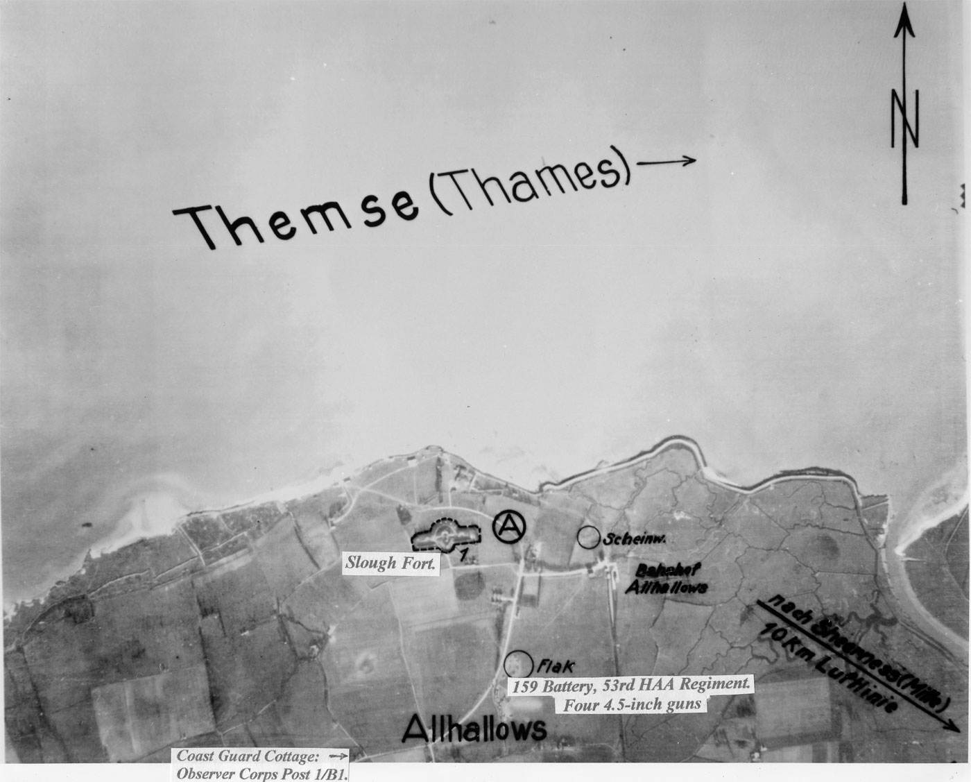  
Last edited by gap; 02-14-14 at 11:22 AM. |
|

|

|
|
02-14-14, 02:24 PM
|
#32 |
|
Ace of the deep .

Join Date: Jan 2006
Posts: 9,226
Downloads: 901
Uploads: 73
|
Attn Mr gap .
I think you are over complicating things , but that's just my opinion . I think because the land in SH5 is quite featureless the light bouys should stay around friendly ports . I don't mind the current bouy sytem as we have now . Adding new bouys might make it even harder for new players . All I ever read about real nav these days is that people disable it because they think it is too hard LOL . Wouldn't it be better to use spy pictures from the actual game ? . Thos e new maps you make are awesome btw . |
|
|
|
|
02-14-14, 02:53 PM
|
#33 | ||||
|
Navy Seal
Join Date: Jan 2011
Location: CJ8937
Posts: 8,215
Downloads: 793
Uploads: 10
|
Quote:
 Quote:
 Quote:
|
||||
|
|
|
|
02-14-14, 08:25 PM
|
#34 |
|
Grey Wolf
 Join Date: Sep 2006
Location: NY
Posts: 995
Downloads: 1078
Uploads: 6
|
Beautiful work sober.
Go gap go. The man with the wealth of knowledge across lots of SH forums!!!
__________________
JSGME help links and common error solutions |
|
|
|
|
02-15-14, 11:14 PM
|
#35 |
|
Ocean Warrior
 Join Date: May 2005
Location: New Castle of Delaware
Posts: 3,231
Downloads: 658
Uploads: 0
|
A small suggestion to make the charts simpler. You could use external elevated screenshots from SH5 as aerial photo reconnaissance for the harbors you want. It will give you the simulation's landmarks as they are. Then add what you want and that's it. Just make sure the photos are line up with actual North at the top.
Back when I was playing B-17 Flying Fortress "The Mighty 8th", that's how guys got the recon photos for all the in game targets. Worked great.
__________________
Gary No Borders, No Language, No Culture =s No Country I'm a Deplorable, and proud of it. |
|
|
|
|
02-15-14, 11:34 PM
|
#36 |
|
Ocean Warrior
Join Date: May 2005
Location: New Castle of Delaware
Posts: 3,231
Downloads: 658
Uploads: 0
|
Another thought. How hard would it be to mod Scappa Flo so the WWI German fleet boats on the bottom would be obstacles. It would make it tougher to get the tonnage required, and a bit nasty to navigate the harbor.... for both sides.
__________________
Gary No Borders, No Language, No Culture =s No Country I'm a Deplorable, and proud of it. |
|
|
|
|
02-16-14, 10:24 AM
|
#37 | ||
|
Navy Seal
Join Date: Jan 2011
Location: CJ8937
Posts: 8,215
Downloads: 793
Uploads: 10
|
Quote:
Quote:
|
||
|
|
|
|
02-19-14, 02:31 PM
|
#38 |
|
Ace of the deep .
Join Date: Jan 2006
Posts: 9,226
Downloads: 901
Uploads: 73
|
The Navy planned underwater harbor defenses against submarines, including magnetic loops to detect the passage of submarines over them and sono-bouys to track the movement of the sub by the sound from their propulsion systems.
Any idea if this is possible ? |
|
|
|
|
02-19-14, 04:53 PM
|
#39 |
|
Navy Seal
Join Date: Jan 2011
Location: CJ8937
Posts: 8,215
Downloads: 793
Uploads: 10
|
As far as I can see, the main problem is that whatever is able to detect and report enemy units, can on turn be detected. Sono buoys and magnetic loops would be reported by our watch crew as "enemy ships", unless we find a way to make them invisible (TDW might have some ides on this subject).
The second problem is: what mix of sensors should we use to simulate magnetic detection? 
|
|
|
|
|
02-19-14, 07:00 PM
|
#40 | |
|
Black Magic
 Join Date: Jun 2007
Posts: 11,962
Downloads: 147
Uploads: 5
|
Quote:
|
|
|
|
|
|
02-19-14, 07:55 PM
|
#41 | |
|
Navy Seal
Join Date: Jan 2011
Location: CJ8937
Posts: 8,215
Downloads: 793
Uploads: 10
|
Quote:
The one little problem with hydrophone sensors, is that we wouldn't be detected if we sneaked in ports on silent running, which is obvioulsy not the best, if we want to simulate magnetic loops. Active sonar could be another good candidate, especially for sono buoys, but also for magnetic loops, if only we could avoid the ping sound in the latter case. By the way: have you checked that hydrophone and sonar sensors can do their job even when fitted on land units (MaxSensorHeight > 0)? |
|
|
|
|
|
03-07-14, 03:24 PM
|
#42 |
|
Navy Seal
Join Date: May 2010
Location: Србија
Posts: 6,078
Downloads: 581
Uploads: 13


|
Sober, have you noticed that bouys charts overwrites whole bunch of Sjizzle charts? Are we dealing with some kind of limited number of ingame charts that can be shown?
__________________
Best regards... Vecko  The Wolves of Steel v2.2.25_SH5 Expansion Pack_Full The Wolves of Steel v2.2.xx to v2.2.25 - Update  PDF Install Instructions How to report an issue  If You wish to support my work... |
|
|
|
|
03-07-14, 03:45 PM
|
#43 | |
|
Ace of the deep .
Join Date: Jan 2006
Posts: 9,226
Downloads: 901
Uploads: 73
|
Quote:
|
|
|
|
|
|
03-07-14, 06:12 PM
|
#44 |
|
Count Dracula

Join Date: Aug 2012
Location: 46°13′N, 24°47′E
Posts: 1,816
Downloads: 405
Uploads: 0


|
charts limit's is 50 and yup when u enable this one some charts of my mods doesn't show ...
__________________
|
|
|
|
|
03-08-14, 01:56 AM
|
#45 | |
|
Ace of the deep .
Join Date: Jan 2006
Posts: 9,226
Downloads: 901
Uploads: 73
|
Quote:
|
|
|
|
|
 |
|
|


 Linear Mode

