
|
|
SUBSIM: The Web's #1 resource for all submarine & naval simulations since 1997
|
SUBSIM: The Web's #1 resource for all submarine & naval simulations since 1997 |
 10-31-08, 03:34 AM
|
#1 |
|
Ocean Warrior
 Join Date: Sep 2008
Location: Notify command we have entered the Grass Sea
Posts: 2,822
Downloads: 813
Uploads: 0
|
How to you read a nautical map? are there any posts that discuss it. I looked and could not find a basic one. I do not understand what the term minutes mean in longitute and latitude describptions. Also, what about may coloring, such as white or shaded areas in the ocean?
|

|

|
|
10-31-08, 09:32 AM
|
#2 |
|
Rear Admiral
 Join Date: Mar 2005
Posts: 13,224
Downloads: 5
Uploads: 0
|
Here is a discussion relating the relative depths for the colors
http://www.subsim.com/radioroom/showthread.php?t=108983 |
|
|
|
|
10-31-08, 12:53 PM
|
#3 |
|
Grey Wolf
 Join Date: Aug 2005
Posts: 930
Downloads: 23
Uploads: 0
|
I'm a landlubber, used to contour maps with grids but the principle is the same with nautical maps. Hopefully I don't screw this up.
i.e. 65° 32' 15" = 65 degrees 30 minutes 15 seconds. If you look on your chart you'll see the grid lines clearly marked with similar numbers(without seconds as the map is not that accurate), the lines themselves being actual degrees and the second number the minutes, each grid being divided into 60 minutes (they are not marked you'll have to guesstimate). The number on the horizontal lines is latitude (Lat) and the Equator is basically your zero line, latitude lines always being parallel to the Equator, the number on the vertical is longitude (Long, aka a meridian line), the zero mark being Greenwich, UK (Prime Meridian). When finding a lat and long on a chart, it's basically "up/down the stairs and out the door"; up/down(depending on which side of the equator you're starting from) the horizontal (lat) lines (like a stair) and find the first number then left or right (depending on which side of the Prime Meridian) towards the vertical lines indicating the longitude (long) number. Lat and Long are further clarified with regard to which direction by using North, South, East and West with the numbers. e.g. Sydney, Austrailia is 33° 52' S and 151° 13' E Obviously Sydney is South of the Equator and East of the Prime Meridian. Although I don't think the charts in the game use the letters. Hope this helps. |
|
|
|
|
10-31-08, 03:04 PM
|
#4 |
|
Captain
 Join Date: Sep 2008
Location: Southeastern USA
Posts: 546
Downloads: 1
Uploads: 0
|
One thing on my map I don't understand is the 360 degree compass. Seems to be backward, 90 degrees is where 270 should be, zero is where 180 should be. Is this right? I have stock game, 1.4.
|
|
|
|
|
11-01-08, 06:37 PM
|
#5 | |
|
Commodore
 Join Date: Jul 2002
Posts: 608
Downloads: 25
Uploads: 1
|
Quote:
That happens because the compass rose is backward. Else, you'd need to first draw the line and then, afterward, use the compass to measure the line. That would work okay for bearings but would make it difficult to plot a specific course. |
|
|
|
|
|
11-01-08, 07:19 PM
|
#6 |
|
Captain
Join Date: Sep 2008
Location: Southeastern USA
Posts: 546
Downloads: 1
Uploads: 0
|
Thanks for explaining that for me. Always wondered about that one.
|
|
|
|
|
11-02-08, 04:47 AM
|
#7 |
|
Ocean Warrior
Join Date: Sep 2008
Location: Notify command we have entered the Grass Sea
Posts: 2,822
Downloads: 813
Uploads: 0
|
I did not understand Mannhausen's post. I am missing something basic I think.
Last edited by I'm goin' down; 11-02-08 at 04:48 AM. |
|
|
|
|
11-02-08, 05:11 AM
|
#8 | |
|
Ocean Warrior
Join Date: Jan 2008
Posts: 2,909
Downloads: 77
Uploads: 11
|
Quote:
Likewise, to plot a course East or 090, then you drag the line to the right and the line between the plot point and the submarine goes through the left of the bearing circle, so it should be labelled as 090 to correctly plot a course.
__________________
-------------------------------- This space left intentionally blank. Last edited by Nisgeis; 11-02-08 at 05:12 AM. |
|
|
|
|
|
11-02-08, 11:18 AM
|
#9 |
|
Commodore
Join Date: Jul 2002
Posts: 608
Downloads: 25
Uploads: 1
|
To illustrate:
Plotting your course ... 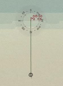 As in Nisgeis' example, you've set a course to the north using the navigator's compass. Since the course line only extends to the center of the compass rose, your true heading must be read along the back side. Taking a target bearing ... 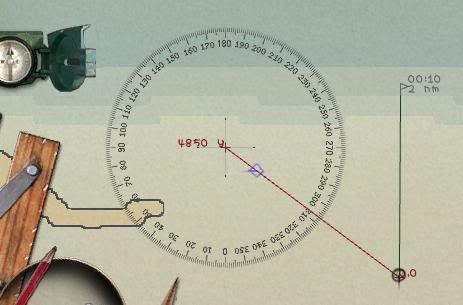 True bearing to the target is about 307 degrees ... again measured on the back side. Measuring target heading ... 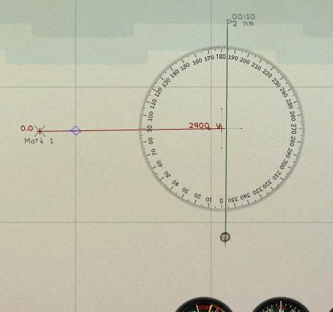 This is the easiest method to plot your target's course ... anchor the line on your first fix, drag the compass over the target, then read the back side (in this case, about 089 degrees). If you like, you can also enter this target heading into the TDC by adjusting AOB. Last edited by Munchausen; 11-02-08 at 11:20 AM. |
|
|
|
|
11-02-08, 12:01 PM
|
#10 |
|
Ocean Warrior
Join Date: Sep 2008
Location: Notify command we have entered the Grass Sea
Posts: 2,822
Downloads: 813
Uploads: 0
|
I'm goin' down wants to introduce you to a couple of city gals and take you to dinner when your boats are in town (San Francisco), a great port town. Thanks. I could have never figured that one out!
|
|
|
|
|
11-03-08, 11:04 AM
|
#11 | |
|
Commodore
Join Date: Jul 2002
Posts: 608
Downloads: 25
Uploads: 1
|
Quote:
|
|
|
|
|
 |
|
|


 Linear Mode

