
|
|
SUBSIM: The Web's #1 resource for all submarine & naval simulations since 1997
|
SUBSIM: The Web's #1 resource for all submarine & naval simulations since 1997 |
|
|
 07-04-13, 08:20 PM
|
#1 |
|
Soundman
 Join Date: Nov 2012
Posts: 146
Downloads: 60
Uploads: 2
|
Apologies, my explanation wasn't clear, I rushed it.
You wouldn't be able to take a bearing at 281 as that's a relative angle of 79 degrees (if you found yourself seeing something for the first time at that bearing, then you could use the Transferred Position Line in the main post  ) ) For Doubled AOB it needs to be less than 45 degrees for it to work - and no less than 10 degrees ideally - best results are at around 30 degrees I find. So on the port side, you can take the first readings from relative bearings 316 up to 350 and on the starboard side 10 to 44. So it's not the bearing that you need to double but the angle. I know it's my fault for not making that clear before. Part of the confusion being what is meant by relative bearing. So a relative bearing of 330 is an angle of 30 degrees, so it's double is (obviously) 60 degrees which is a relative bearing of 300. Pretty Pictures and Example (I find it much easier to explain with images) So in this example, I plotted your course the same as your example, 303T. 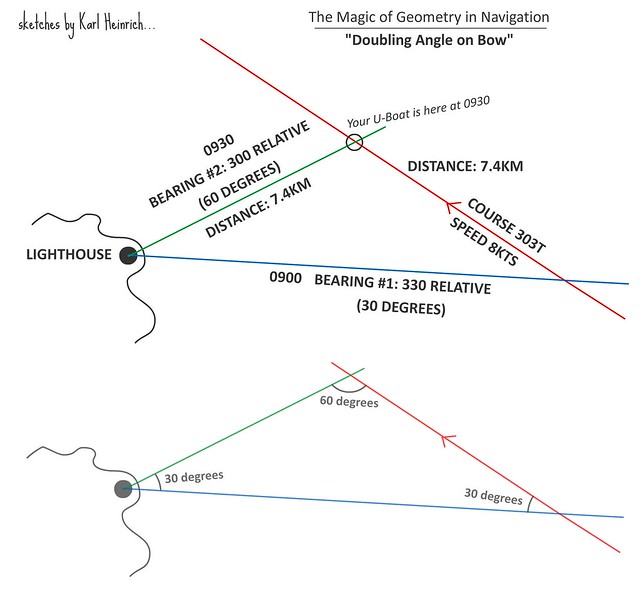 As always it's important to keep your speed and heading constant (I know you already know this LemonA). Through the UZO or 'scope, you spot a lighthouse ahead. You wait till you know you will get a good bearing for a fix. At 330 relative bearing on the UZO/Scope you plot the position line on the map and note the time - 0900 GMT. As this gives you 30 degrees AOB to the lighthouse, you keep checking till you have 60 degrees AOB to the lighthouse - relative bearing of 300 (on the UZO/scope reading). Travelling at 8kts, this takes you 30 minutes - consulting the charts tells you that you have travelled 7.41 KM. You've plotted this on your map and this gives you a nice isosceles triangle - so you know you have two lines of equal length - we know the distance from bearing #2 to your position is the same as the distance travelled along the course. Check bearing line #2 against your log, you know you've travelled 7.4 km so check with the ruler that bearing #2 is 7.4 km. If you've stayed on course this should be where line #2 and your course line meet. If not, then you are roughly where your ruler line ends at 7.4km... I feel like I've made this even more complicated now, I really hope it makes sense. You can also do it where the first bearing is 45 degrees AOB and the second 90 degrees AOB, that's slightly more accurate generally. -------- As I said, I planned to do a proper tutorial for this too... Trying to translate certain RL things to SH does need a bit of tweaking doesn't it, it's almost impossible to take compass bearings as you would IRL unfortunately. With this it's much easier to work out the "relative bearing" without ambiguity. On the plus side of course we know in SH magnetic north = true north so no need to calculate for magnetic deviation.
__________________
Die Südfrüchte runter vom Kartentisch. Auf Bananen kann ich nicht navigieren. Last edited by Karl Heinrich; 07-06-13 at 07:18 AM. |

|

|
|
07-04-13, 08:53 PM
|
#2 |
|
Lieutenant
 Join Date: Jan 2012
Posts: 252
Downloads: 66
Uploads: 0
|
Found "Double the Bow" formula:
AoB_2 = AoB_1 + (180 - (2*AoB_1)) , if AoB_1 < 90 not available , else with AoB_1 is first AoB shot and AoB_2 is second AoB shot. Example: AoB_1 = 13 AoB_2 = 13 + (180 - (2*13)) = 167
__________________
Robert Schmidt, LTJG U-43 |
|
|
|
|
07-04-13, 09:05 PM
|
#3 |
|
Soundman
Join Date: Nov 2012
Posts: 146
Downloads: 60
Uploads: 2
|
That seems needlessly complicated lol. That looks like a TDC targetting formula. We just need to count down or up from 360/0.
IRL you'd point a compass at the lighthouse and subtract the compass bearing from your heading to get the appropriate relative bearing. So on a heading of 303T we point the compass at lighthouse, compass says 283. 303 - 283 = 20. So we know we need a second reading when it's 40, working backwards 303 - 40 = 263. Doesn't work quite the same in SH but the principle is the same of course.
__________________
Die Südfrüchte runter vom Kartentisch. Auf Bananen kann ich nicht navigieren. Last edited by Karl Heinrich; 07-04-13 at 09:16 PM. |
|
|
|
|
07-04-13, 09:14 PM
|
#4 | |
|
Lieutenant
Join Date: Jan 2012
Posts: 252
Downloads: 66
Uploads: 0
|
Quote:
__________________
Robert Schmidt, LTJG U-43 |
|
|
|
|
|
07-04-13, 09:22 PM
|
#5 | |
|
Soundman
Join Date: Nov 2012
Posts: 146
Downloads: 60
Uploads: 2
|
Quote:
I have tried doing vague bearings from the compass on the bridge though, good for confirming bearings but bloody useless if you want anything precise lol.
__________________
Die Südfrüchte runter vom Kartentisch. Auf Bananen kann ich nicht navigieren. |
|
|
|
|
|
07-04-13, 09:37 PM
|
#6 | |
|
Lieutenant
Join Date: Jan 2012
Posts: 252
Downloads: 66
Uploads: 0
|
Quote:
Maybe you add to your list also "Danger bearing", a fundamental coastal navigation method.
__________________
Robert Schmidt, LTJG U-43 |
|
|
|
|
|
07-04-13, 09:51 PM
|
#7 | |
|
Soundman
Join Date: Nov 2012
Posts: 146
Downloads: 60
Uploads: 2
|
Quote:
I'd not included danger bearings as SH3 doesn't simulate enough detail to warrant them (shoals etc), at least not in my experience which I know is rather less than many here. So if you're going to crash into land it should be hard to miss, otherwise you deserve to... I suppose it might be worth including for submerged navigation and night-time running. I'll leave it till last though, for the most part in SH just applying common sense is the easiest way to go of course
__________________
Die Südfrüchte runter vom Kartentisch. Auf Bananen kann ich nicht navigieren. Last edited by Karl Heinrich; 07-05-13 at 05:52 AM. |
|
|
|
|
|
07-06-13, 04:42 AM
|
#8 |
|
Soundman
Join Date: Nov 2012
Posts: 146
Downloads: 60
Uploads: 2
|
What I might also do, although it's rather time consuming, is create soundings data on the in-game map (with printable versions too) - obviously this will have to be done in rather small areas at a time. And based on contemporary KM charts - we won't get anything that they didn't have.
__________________
Die Südfrüchte runter vom Kartentisch. Auf Bananen kann ich nicht navigieren. |
|
|
|
|
07-06-13, 05:45 AM
|
#9 |
|
Admirable Mike

Join Date: Mar 2004
Location: Canada
Posts: 1,338
Downloads: 421
Uploads: 0
|
Thank you for your work.
Not only is it useful in game, but also to understand concepts and terminology such as relative bearing. I also use a technique for setting an intercept course on a radio announced contact. I use the ruler to run their course line forward and another ruler line to that line from my position. Of course I have to ask the navigator to do a fix to get that position. (Using TDW Real Navigation mod) Then I determine when I and they will reach the crossing point, using an estimate of their speed. To shorten that time I move along their course line, drawing added lines to my point. Each new line changes the distance I must move and so the time to arrive. Eventually I will get an optimum time to contact without needing a ridiculous speed on my part. Then I set course and speed to reach their location and go hunting. (The above is open water navigation, just related to what you discussed.)
__________________
Game Designer: Close The Atlantic - World War Three https://boardgamegeek.com/boardgame/...orld-war-three |
|
|
|
 |
| Tags |
| navigation, plotting, real navigation, running fix, running fixes |
|
|


 Hybrid Mode
