
|
|
SUBSIM: The Web's #1 resource for all submarine & naval simulations since 1997
|
SUBSIM: The Web's #1 resource for all submarine & naval simulations since 1997 |
|
|
 04-28-12, 04:40 PM
|
#1 | |||||
|
Bosun
 Join Date: Apr 2012
Posts: 67
Downloads: 93
Uploads: 0
|
Quote:
Quote:
I then tried different gane resolutions (1024 and 1152) and found that the 3000 yrd range circle measured 1650 with the ruler when the game was set at 1152 (for all versions of the mod) and 1900 yrds when the game was set at 1024 (again for all versions of the mod). It is as though there is no effect of the different versions on the scaling in the game. Quote:
Quote:
========== Quote:
I appreciate your help. Tom |
|||||

|

|
|
04-28-12, 07:17 PM
|
#2 | |||
|
Admiral
 
Join Date: Apr 2005
Location: Dayton, Ohio
Posts: 2,292
Downloads: 474
Uploads: 64


|
Quote:
Tom, I have a NEC MultiSync monitor 4:3 aspect ratio, with a Windows desktop resolution of 1280x1024. I can run a dozen different game resolutions through the monitor without too much distortion. I usually set my game resolution to whatever I choose that looks right for me. As the below image shows, I've set the game graphic options to the setting you use.....1152x864. 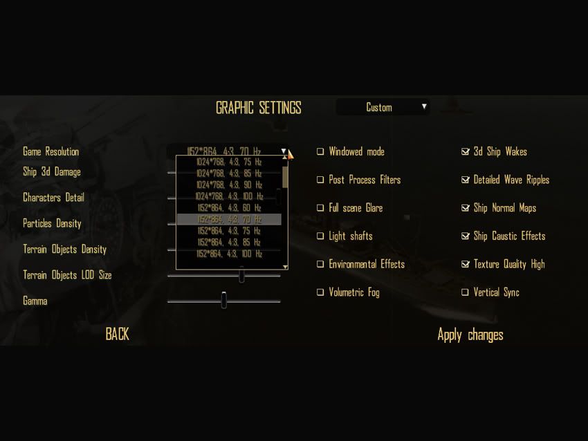 I've loaded the "Optical Targeting Correction" mod for the stock 1.5 game, with the "3000 Yard Bearing Tool (1152x)". No other mods loaded. I guess I did call it a "Tool" when you have it extracted to JSGME! The "Downloads" title is a "Plotter".  I started a fresh campaign, out of Pearl, at the start of the war, using the Porpoise class sub. Going to the Navigation Map I zoomed in on the sub and ran a ruler line out from the center of the sub to the lines. Here's the result:   Both measured as they should, at the different zoom sizes. A couple of things about the ruler. The center of the sub is where you start the measurement. As a matter of fact, all measurements are made from the center of the sub to the center of the target. Not from the closest side, to closest side. Also, as you drag the ruler out, you'll notice it has the measurements in 50 yard increments. This is how the developers patched the ruler. We should be thankful they did that much for us. The original SH4 game (version 1.0) was released using only the metric system unit of measurements (where's the authenticity for an American Fleet Boat?), plus the map ruler used 10ths of nautical miles in its increments!! What's a 10th of a nautical mile figure out into yards? Talk about not being user friendly! Anyway, as the following image shows the 550 yard increment stays at 550 until it makes the true distance of 600 yards. 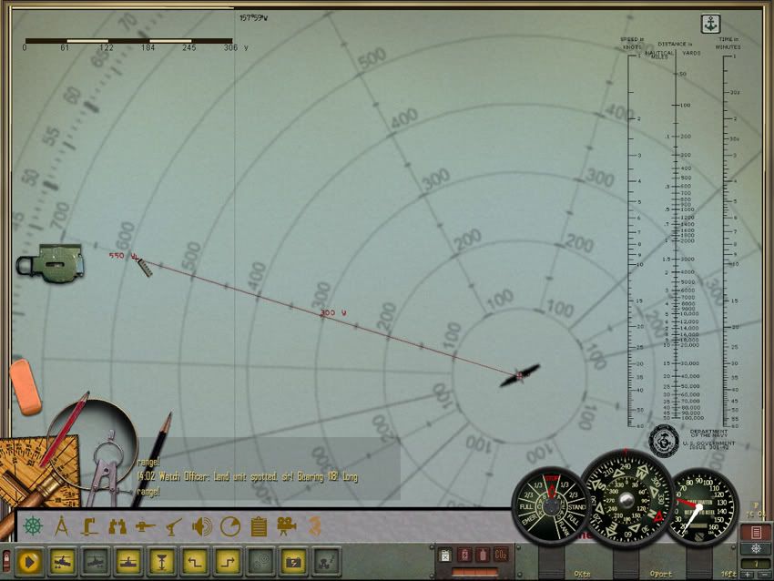 Same for the 2950 yard measurement. 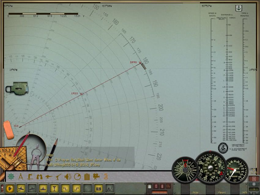 It's important to know that where the ruler makes the increment change, from one 50 yard increment to the next, is the correct true distance. The rest of the measurement is just a calculated guess. Also, don't count on the measurements given somewhere between the end point and starting point to be accurate either. The farther you pull the ruler, those listed measurements between the two points get misplaced more often than not. Quote:
Please don't take offence by this, but are you sure you're using the correct Yard Plotter for the imperial unit of measurement option? Could it be the Plotter is the metric one? Is the game set to use the metric system rather than the imperial? Just asking  =========== I tried a quick test using the Navigation school mission. Same two mods. I zoomed in on one of the PT boats in front of the sub and measured the Plotter lines again. No difference in measurement. 500 yards at 500 yards. 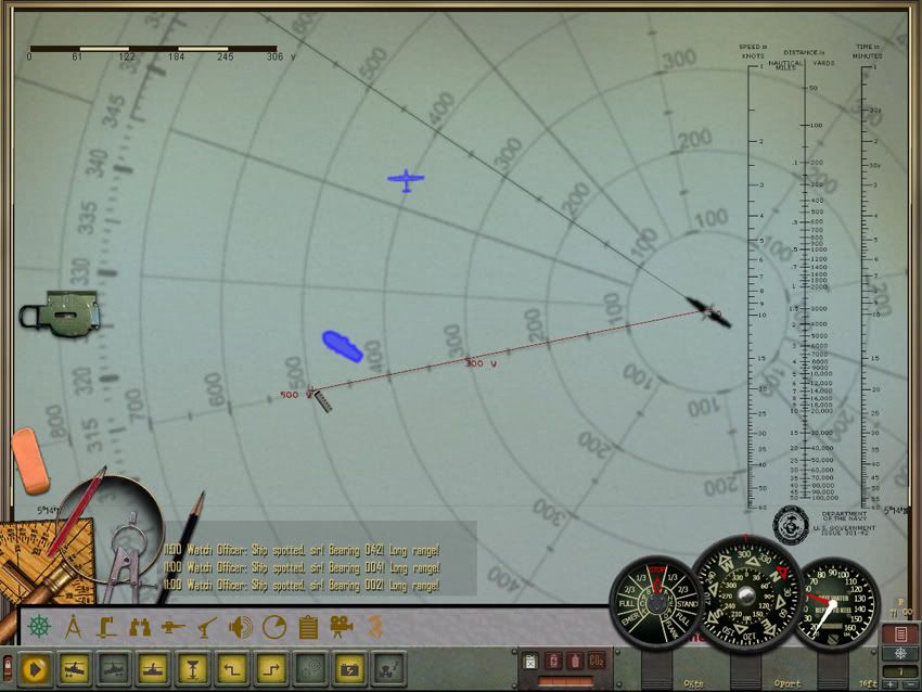
__________________
 The HMS Shannon vs. USS Chesapeake outside Boston Harbor June 1, 1813 USS Chesapeake Captain James Lawrence lay mortally wounded... Quote:
|
|||
|
|
|
|
04-28-12, 07:43 PM
|
#3 |
|
Bosun
Join Date: Apr 2012
Posts: 67
Downloads: 93
Uploads: 0
|
I appreciate all the effort you are taking.
I am using the Imperial plotter and have "imperial" set in the game options. One other thing I noticed. In your last screen shot, the scale bar at the top left show 0 to 306 yrds, which agrees with the 0 to 300 yrd ring on the plotter. On my computer, when I zoom the map so that the scale bar shows 0 to 3000 (and change), that bar length is close to the total diameter of the plotter (not the radius). I wonder if the video card could be causing an issue. The thing that confuses me is that regardless of which version of the mod I load (matching or not matching the game resolution), the scaling only depends on the game resolution, not on both game and mod resolution as I would expect. A different video symptom I have is that the mouse cursor doesn't track in the game as precisely as it does in windows. I have to play "chase the cursor" in order to land it on a specific control. I'm not sure if that is normal or not. Tom |
|
|
|
|
04-29-12, 10:24 AM
|
#4 | |
|
Admiral
Join Date: Apr 2005
Location: Dayton, Ohio
Posts: 2,292
Downloads: 474
Uploads: 64
|
Tom, I've never trusted the "scale bar" to give me an accurate sense of the true measurement of the map. For so long, this feature was screwed up with the stock game, I usually ignore it altogether. I took a second look at the map using a lower zoomed level and yes, the scale bar physical length actually stays the same in all zoomed screens. What changes is the listed measurement of the scale bar. It seems to be accurate. The image below is from the "Torpedo" training school mission.
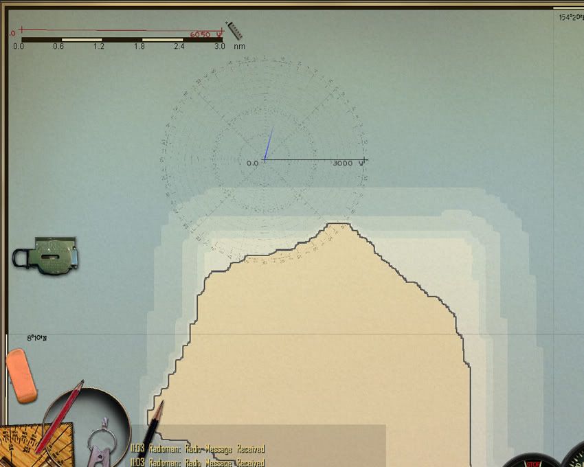 In the above image the scale bar states the length is 3nm (nautical miles). When using the ruler, it measures 6050 yards. That's pretty close; actual conversion of 3nm to yards is 6076 yards. The ruler isn't going to give you a nuts-on measurement anyway, only in 50 yard increments. As the image shows, I've drawn a ruler line from the center of the sub out to the 3000 yard line. It still reads accurately. I know if you change the graphic resolution on the game options page, you need to change the 3000 Yard Bearing Plotter to match the horizontal figure of the resolution you choose. That's why there are so many different versions of the Plotter. For example, changing the in-game resolution to 1024x768 you'll need to use the "3000 Yard Bearing Plotter (1024x)". The 4:3 aspect ratio is the same for both 1024x and the 1152x resolution. Unlike the OTC mod which has to match the aspect ratio of the game to have the periscope view corrected. To have the Plotter read correctly on the nav map you need to make a match with the horizontal resolution figure (not the aspect ratio). Sorry I can't help you if you suspect the video card isn't up to snuff. As long as it's compatible to what SH4 states it should be, I'm at a loss to telling you any different. I know the computer I've taken the images from isn't a cutting edge system; far from it. Over 8 years old! The video card is an AGP slot, ATI Radeon HD 4670, 1 GB of DDR3 ram. Hardly a power house now a days. The mouse lag could be a clue to problems. That's not normal.
__________________
The HMS Shannon vs. USS Chesapeake outside Boston Harbor June 1, 1813 USS Chesapeake Captain James Lawrence lay mortally wounded... Quote:
|
|
|
|
|
 |
|
|


 Hybrid Mode
