
|
|
SUBSIM: The Web's #1 resource for all submarine & naval simulations since 1997
|
SUBSIM: The Web's #1 resource for all submarine & naval simulations since 1997 |
|
|
 09-13-10, 10:42 PM
|
#1 | ||
|
Admiral
 
Join Date: Apr 2005
Location: Dayton, Ohio
Posts: 2,292
Downloads: 474
Uploads: 64


|
Quote:
I've checked each and every edition, and in my opinion, the 3000 yard or meter versions are accurate. If I'm wrong I'll need to correct my mistake. So I've got to ask you, what edition are you using? With what unit of measurement? At what resolution is the game running in? Just a couple of notes, make sure you know what resolution your game is running in, not what resolution your Windows desktop setup uses. They can easily be different. Use the correct Bearing Plotter edition for what the game resolution is set AND the correct unit of measurement you're using in-game. Second, when you're using the ruler tool to measure distances, the units are broken down into increments of 50 (50 yards/50 meters). The point where the unit of measurement changes to the next division, marks that particular distance. For example, the ruler shows 750 meters, as you drag it further from the start point it will change to 800. This specific point of change is the 800 meter distance. The ruler will continue to read 800 meters until you reach the next 50 unit mark at 850. Further, a ship is positioned at the center of its distance or range, not at the leading edge of it. Using the Kongo again, its positioned exactly centered on the 1325 yard distance, even though the ships side (closest to the sub) is very near the 1300 yard line. The game figures measurements not on side distances or range to the edge of the target but on the center position of the object.
__________________
 The HMS Shannon vs. USS Chesapeake outside Boston Harbor June 1, 1813 USS Chesapeake Captain James Lawrence lay mortally wounded... Quote:
Last edited by CapnScurvy; 09-13-10 at 11:04 PM. |
||

|

|
|
09-13-10, 11:14 PM
|
#2 |
|
XO
 Join Date: Sep 2002
Location: New York City
Posts: 408
Downloads: 439
Uploads: 0
|
Great stuff! Thanks Capn!

|
|
|
|
|
09-14-10, 08:49 AM
|
#3 | |
|
Mate
 Join Date: Jun 2005
Location: Unknown ... until it's too late!
Posts: 60
Downloads: 149
Uploads: 0
|
Quote:
__________________
I am. Therefore, I sink. |
|
|
|
|
|
09-14-10, 10:35 AM
|
#4 | |
|
Admiral
Join Date: Apr 2005
Location: Dayton, Ohio
Posts: 2,292
Downloads: 474
Uploads: 64
|
Well, now that you bring it up I've doubled checked the Big Bearing Compass heading with the navigation map plotter and I do see a 1 degree discrepancy in what the periscope shows and what the plotter shows SOMETIMES?!? The plotter should be turned approximately 1 degree clockwise on a couple of the nearer ships. However, when I've gone out to the 3000 range areas the compass reading and the plotter bearings are exact!! Like I said, I didn't make the thing, I just scaled it to fit the various resolutions that are used. I'm sorry to have not checked it with a better tool.
Soooooooo, I'm going to fix the images and release the corrected version if I determine this is a big deal or not. If the 1 degree of difference doesn't make a difference to you then go ahead and use what's up on the download. I'll need to make 208 file changes; 13 stock subs x's 16 different mods. I just assumed the darn plotter was corrected for this long time known error of 1 degree off center!!!!! Guess not the version I used. And you know what they say about assuming!! I'm interested about the error in distance you described though. Where is the error there? If I'm going to rework the plotter and remake the mods I'd like to do it only one more time.
__________________
The HMS Shannon vs. USS Chesapeake outside Boston Harbor June 1, 1813 USS Chesapeake Captain James Lawrence lay mortally wounded... Quote:
Last edited by CapnScurvy; 09-14-10 at 05:25 PM. |
|
|
|
|
|
09-14-10, 01:03 PM
|
#5 |
|
Mate
Join Date: Jun 2005
Location: Unknown ... until it's too late!
Posts: 60
Downloads: 149
Uploads: 0
|
Capn, your distance is right on. I just mentioned 3000 yards as it was that compass circle on the plotter tool that indicated that 0 degrees on the plotter tool was different from one's plotted course.
__________________
I am. Therefore, I sink. |
|
|
|
|
09-14-10, 03:06 PM
|
#6 | ||
|
Admiral
Join Date: Apr 2005
Location: Dayton, Ohio
Posts: 2,292
Downloads: 474
Uploads: 64
|
Hydra, I've been further checking and I'm at a quandary as to what to do about this 1 degree discrepancy. The follow images are from a game using 1600x1200 resolution.
The first image is at the periscope station with a ship at 1004 yards distance. The bow is centered on a compass reading of almost 356 degrees. 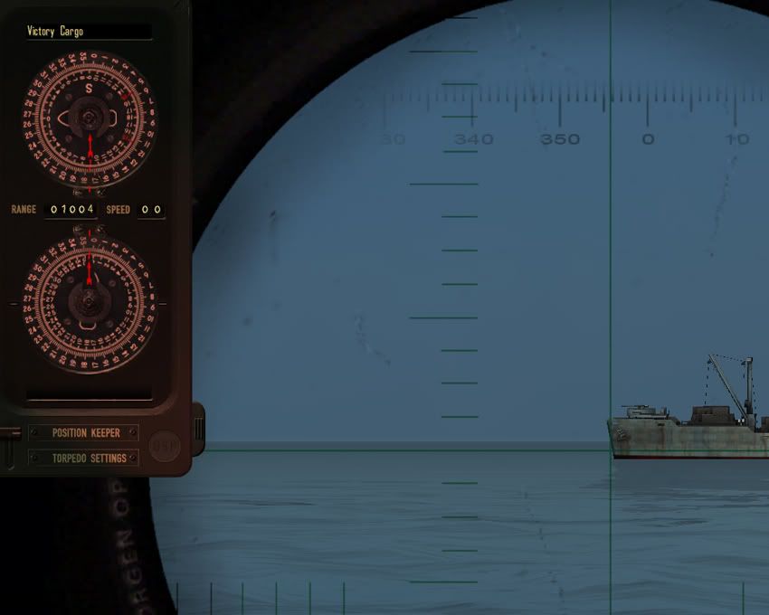 So we go to the navigation map and the same ship is at the correct range but the compass reading is at 357 degrees. Ah Haa! Here's the discrepancy we've been talking about. 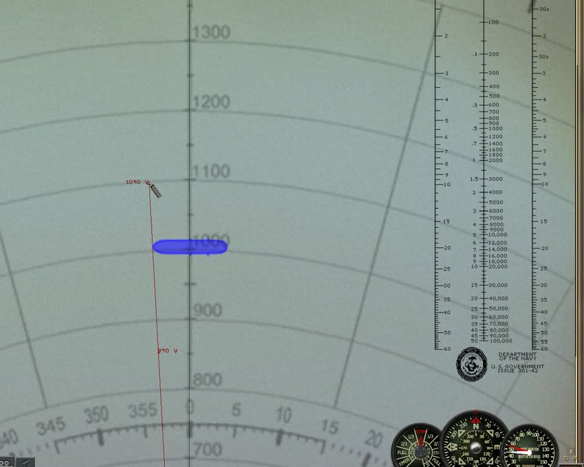 So I go to check another ship sitting out at the 3000 yard range and find it's bow at almost the 342 degree mark. 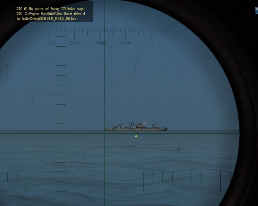 But wait, the bow reading is just half a degree off from what the periscope compass read!?! You would think the reading should read at least the same difference as the 1000 range ship. 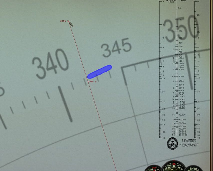 And here's a third target sitting at 1500 yards, with a bow compass reading of 18 1/2. 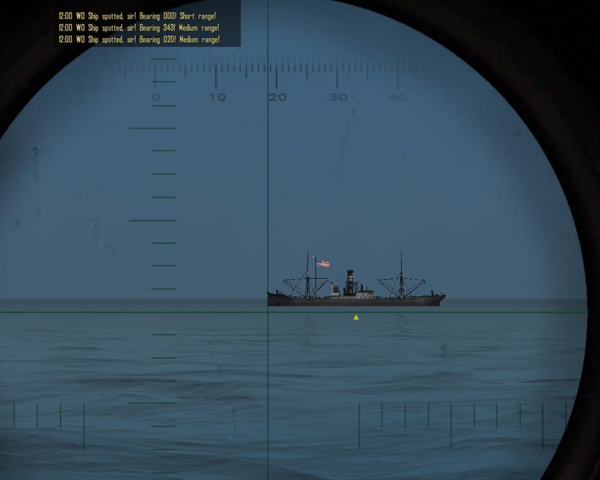 The same ship on the plotter reads exactly 18 degrees. 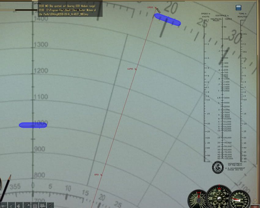 So here's the rub, if I move the plotter the 1 degree clockwise to correct the first ships discrepancy, the ship at the 1500 yard position will end up with it's bow at the 17 degree mark. So we correct one and make worse another. Actually the 3000 yard ship would be a wash, it is only a half degree off when compared to the periscope compass. Moving the plotter clockwise by one degree will have it then at a half degree difference on the other side of 342. I've checked this with a couple of other resolutions and have found the same differences. So unless I see a positive reason to change things, I'm just as well to let the sleeping dog lie. Compared to what the dev's gave us when the game first came out (the measuring units were in Nautical Miles for crap sake!!!!) one degree difference is dead on target to me. Quote:
__________________
The HMS Shannon vs. USS Chesapeake outside Boston Harbor June 1, 1813 USS Chesapeake Captain James Lawrence lay mortally wounded... Quote:
Last edited by CapnScurvy; 09-14-10 at 03:50 PM. |
||
|
|
|
|
09-14-10, 04:57 PM
|
#7 |
|
Loader
 Join Date: Apr 2005
Location: Texas
Posts: 86
Downloads: 23
Uploads: 0
|
A BIG THANK YOU
|
|
|
|
|
09-17-10, 03:08 PM
|
#8 |
|
Navy Seal
 Join Date: Mar 2007
Location: DeLand, FL
Posts: 8,900
Downloads: 135
Uploads: 52

|
Capn, my original automatically changed units from imperial to metric when you switched boats from sub to U. I like to use native tools for both. It's easy to do. You want to do it or should I?
Great job there. Downloaded!!!! 
__________________
Sub Skipper's Bag of Tricks, Slightly Subnuclear Mk 14 & Cutie, Slightly Subnuclear Deck Gun, EZPlot 2.0, TMOPlot, TMOKeys, SH4CMS |
|
|
|
 |
|
|


 Hybrid Mode
