
|
|
SUBSIM: The Web's #1 resource for all submarine & naval simulations since 1997
|
SUBSIM: The Web's #1 resource for all submarine & naval simulations since 1997 |
 10-08-09, 05:32 AM
|
#31 | |
|
Grey Wolf
 Join Date: Nov 2008
Location: Running silent and deep
Posts: 902
Downloads: 3
Uploads: 0
|
Quote:
Of course, we might have both... 
|
|

|

|
|
10-08-09, 07:14 AM
|
#32 | |
|
Helmsman
 Join Date: Jul 2003
Location: Europe
Posts: 101
Downloads: 0
Uploads: 0
|
Quote:

|
|
|
|
|
|
10-10-09, 09:20 PM
|
#33 | |
|
XO
 Join Date: Mar 2007
Location: Colorado, for now. Any RED State, ASAP.
Posts: 401
Downloads: 77
Uploads: 0
|
Quote:
|
|
|
|
|
|
10-14-09, 05:43 AM
|
#34 |
|
Pacific Aces Dev Team
 Join Date: Mar 2001
Location: Northern Germany
Posts: 1,096
Downloads: 169
Uploads: 0
|
According to a dev-answer on the german ubi-forum, the earth is again a cylindrical projection. They have tried other projections, which used a real globe, but the barriers to usability, freedom and clarity were just too big to develop this further. There were also some technical difficulties which arised in connection with other geographic projections.
__________________
-- Vapor-ware is always easier to sell because there's no limit what it can do! |
|
|
|
|
10-14-09, 05:47 AM
|
#35 | |
|
Subsim Aviator

Join Date: Mar 2007
Location: Texas
Posts: 8,726
Downloads: 146
Uploads: 0


|
Quote:
 understandable but unfortunate
__________________

|
|
|
|
|
|
10-14-09, 07:59 AM
|
#36 |
|
Commodore
 Join Date: May 2007
Location: Sneek, The Netherlands
Posts: 635
Downloads: 43
Uploads: 0
|
Somethin for SH6 then
maybe have different maps to navigate on.. so you have to change them during your mission. |
|
|
|
|
10-14-09, 08:18 AM
|
#37 | |
|
Sparky
 Join Date: Jan 2007
Location: Hannover, Germany
Posts: 158
Downloads: 39
Uploads: 0
|
Quote:
If you restrict zoom levels, then some sort of RenderToTexture could calculate our maps and the engine could display them on a rectangle surface in 3D or 2D. I don't think that would confuse anyone because it would still look the same. In fact, with the according love to eye-candy, it would look like original ones.
__________________
I hope alot of people will buy SHV. I will and I will mod it and play it. Keep in mind if we don´t buy it, the next SH title will look like this and you can look forward to a starfish addon...  
|
|
|
|
|
|
10-15-09, 04:03 AM
|
#38 |
|
Watch
 Join Date: Feb 2008
Location: -14 m. below Lake Leman :-D
Posts: 15
Downloads: 8
Uploads: 0
|
I really would not reiterate on this stuff as it could be seen as whining by the developers (which I dearly thank for their effort).
However, I really cannot understand what is the problem with these charts. I think the following compromise could be extremely easy to implement and the newbie will not even notice the complexity. So, let's start. I guess that, as pointed up before, far away ships are not floating by in the oceans but are just entries in a database. The latter contains the informations that are used to generate the 3D local bubble which is centered on the player's sub, which is probably itself an entry in this database. Now, I can see no reason why the map that we are to see in the command room HAS to have the same "geometry" as the database. I will explain more in detail. The objects are located by two coordinates on the (mercator) map, let's say X and Y. The geometry is that of a flat plane, so this generates the well known distortions of distances and speeds the further we move from the equator. BUT, the map has only to provide our position! We do not want to LIVE on the map So: in the internal database use the real latitude and longitude coordinates (say, Phi and Lambda). The corresponding projection on our map will be then given by (Wikipedia + me): X = Lambda Y = Ln[ Tan(Phi) + Sec(Phi) ] The movement are computed with the true coordinates (and updated in the database) with the formula: V = R d_Phi / d_t + R Sin(Phi) d_Lambda / d_t (also wikipedia or any bachelor-level geometry book). This would be completely masked to the user (hence no problem with newcomers), and this will work the same way as the system which is used now to compute the movement of the objects. Only, much more accurate for the people who care. This also will not prevent you to click on the map to plot your course, as before. But this time taking the straight line will not be the shortest one. A simple geodetic calculator can also be implemented in the navigator AI so that when you click on the map, instead of drawing the straight line, the guy plots an approximation to the good geodesic (say, using 10 or 20 intermediate points). Thanks for reading ...and thanks again to the developers |
|
|
|
|
10-15-09, 05:30 AM
|
#39 | |
|
A-ganger
 Join Date: Dec 2008
Location: Germany
Posts: 76
Downloads: 79
Uploads: 0
|
Quote:
|
|
|
|
|
|
10-15-09, 07:53 AM
|
#40 |
|
Ace of the Deep
 Join Date: Dec 2004
Location: Valhalla: Silent Generation
Posts: 1,149
Downloads: 910
Uploads: 0
|
I must add my voice to those who desire SH5 to include an accurate chart and celestial firmament for the years 1939-1945.
As all navigators know, real progress over/under/on sea during WWII was conducted on paper, using real tools. All through SH3 and SH4 I was content to use Stellarium and Phython to obtain my Line of Position off screen on real paper, using dividers, compass, parallel rule, and protractor and making my own charts; and for the last two years have been playing TC x1. Ive been taking my dawn, forenoon, noon, afternoon, evening twilight sights to get my boat around the F5 screen. I also have a ton of recycled paper to prove it. My accuracy varied with the weather, sleepy helmsman and my own mistakes converting game time to UTC (GMT). Many times my position was unknown due to overcast skies, but through it all, it was great immersion. It was one of the reasons I enlisted, (bought the game). Im one of those players, now closer to 70 than to 60, who will admit the thing that would pinch my cheeks is an accurate sextant tool, like the one featured in Virtual Sailor-7, to compliment whatever is doable for the Devs.
__________________
[SIGPIC][/SIGPIC] During times of universal deceit, telling the truth becomes a revolutionary act. ~ George Orwell |
|
|
|
|
10-15-09, 01:26 PM
|
#41 | |
|
Ensign
 Join Date: Oct 2007
Location: United Kingdom
Posts: 221
Downloads: 41
Uploads: 0
|
Here is the actual quote from the Q&A:
Quote:
UPDATE: Also, If they dont have a globe, and its possible to mod the map (but not change it's shaper) maybe some team can stretch the land masses in the right way so as the effect would be the same? Would that work? Like taking the surface of a globe and placing it flat? UPDATE 2: So the nav map (and world itelf as im proposing) would look like this: 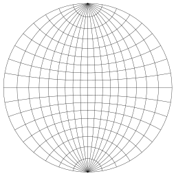 From the above quote this image below may be what the team are doing currently: I don't know... the cylinder looks an ok solution now that i see it, but if the in-game world will still be flat still (just with the landmasses altered) why not use the first diagram I posted?. Or is that what we've been asking for/talking about all along? A flat world that works like the real thing? I thought we were talking about wanting a real 3D globe up to now, one where you would have real lines of sight to ships partially over the horizon and was only projected flat for the nav. map.
__________________
Rest in peace Dave Last edited by fireship4; 10-15-09 at 03:09 PM. |
|
|
|
|
|
10-15-09, 02:53 PM
|
#42 |
|
Chief
 Join Date: Jul 2005
Posts: 316
Downloads: 28
Uploads: 0
|
ha! great idea!!! i know some modders are able to alter terrain... if the distances arent correct because of a flat world, why not correct them by altering the terrain?? imo this should be possible... but i think it would be tons of work... perhaps a modder can give an idea here...

__________________
Everything comes to him who waits |
|
|
|
|
10-15-09, 03:09 PM
|
#43 | |
|
Pacific Aces Dev Team
Join Date: Mar 2001
Location: Northern Germany
Posts: 1,096
Downloads: 169
Uploads: 0
|
Quote:
  If someone want to know more about the techniques, the data structures, sourcecodes and many more about virtual earth rendering in realtime application, go investigate the links here: http://www.vterrain.org/
__________________
-- Vapor-ware is always easier to sell because there's no limit what it can do! |
|
|
|
|
|
10-15-09, 03:22 PM
|
#44 |
|
Ensign
Join Date: Oct 2007
Location: United Kingdom
Posts: 221
Downloads: 41
Uploads: 0
|
Well Im sure that if you reach the edge you appear on the other side of the map - like asteroids. Apeearing on the other side obviously doesn't work if you have an incomplete map (the cylindrical map above doesnt include austrailia) as you would be warping hundreds of miles instantly.
That pic reminded me of the discworld just now.
__________________
Rest in peace Dave |
|
|
|
|
10-15-09, 04:04 PM
|
#45 |
|
Watch
Join Date: Feb 2008
Location: -14 m. below Lake Leman :-D
Posts: 15
Downloads: 8
Uploads: 0
|
To fireship4:
Mathematically, a plane and a sphere are two completely different animals. It means that, if you want to represent a spherical surface on a flat one you have to give up something. What you loose depends upon which kind of projection, or chart, you choose. I guess the developer wanted to say that the map that you see in the simulation MUST be a Mercator projection. http://en.wikipedia.org/wiki/Mercator_projection The advantage to the casual user is enormous. It is the only chart which allows you to plot constant bearing courses as straight lines. If you depart from ol'Mercator, you loose this and I can see why the developers do not want it. to Jaeger: You can try and correct some areas and distances for some precise parallels, say the 45, as in the Gall-Peters projection, but you screw up elsewhere (along the equator typically, as the poles are already screwed due to the cylindrical projection) http://en.wikipedia.org/wiki/Gall%E2...ers_projection However, due to the inherent difference between a sphere and a plane you will always have distortion on the distances. To rosentorf: For what I understand, the only viable solution would be to have all the internal computations done in a true spherical surface and then showing the results on a flat map by projecting the positions. This way is actually what happens in reality, when you use ANY map to keep track of your position. Its chart will introduce errors in distances, shapes, areas, directions. But if you move, these will not affect you because you move in the true spherical surface. Besides, on a sphere you always have a flat enough neighbourhood, so that if you really wanted to go for ultimate precision you could transform to local coordinates when you plot the attack map. This would be the best IMHO. However it will introduce an additional level of complexity for the developers to program. I believe that since you will engage targets at most 2000-3000 meters away you will not miss the target due to approximations due to plotting a "rectangular" attack run on a "curved" world. We could therefore obtain the best of the two worlds with very simple modification to the existing code. This, of course, if there are no other showstoppers I may have naively missed in this digression. What I would love to see, maybe for modders to attack, is a distinction between the database of objects and the actual map, and maybe with the database programmed in human-readable format. In this way the programmers could give us a working cylindrical projection (so a flat map) coming out from a flat world (with appropriate boundary conditions). But if the two are distinct, maybe (a big maybe), modding could introduce later a different database and the relative chart to show it in the commands room map. But these are just speculations, we really need a developer to tell us if it is feasible or not, etc. Thanks again for reading, you all  
|
|
|
|
 |
|
|


 Linear Mode

