
|
|
SUBSIM: The Web's #1 resource for all submarine & naval simulations since 1997
|
SUBSIM: The Web's #1 resource for all submarine & naval simulations since 1997 |
 03-10-22, 02:24 PM
|
#1 |
|
中国水兵
 Join Date: Jun 2019
Posts: 270
Downloads: 558
Uploads: 0
|
Navigation Bathymetry Map 2022 (Stock version) 27.08.2022
1. The Archipelago of Saints Peter and Paul has been added to the map. 2. Orinoco and Amazon have been added to the map. 3. The River Thames has been added to the map. 4. The island of Sula Sgeir has been added to the map, as well as the heights of the island of Rhone have been redone. 5. Tjeldoya Slott Skerry Pass has been redesigned. Reworked depths in the Narvik and Harstad areas. Download: https://drive.google.com/file/d/1evW...ew?usp=sharing --------------------------------------------------------------------- Navigation Bathymetry Map 2022 (Stock version) 03.08.2022 Additions: The depths of the Gulf of Mexico have been redone, the Caspian Sea has been added to the game, the Volga-Don navigable canal (Caspian Sea) was built, the Kiel Canal was improved, in the Brest area, the Goulet-de-Brest passage was built, the Ria-le-Conque bay was built. In general, the Brest area has been improved, islands built in an earlier version have been removed from the map. fashion. Download: https://drive.google.com/file/d/1PHH...ew?usp=sharing ------------------------------------------------------------------------------------------------------------- Navigation Bathymetry Map (Stock version Final) 12.06.2022 The final version of the mod. 1) In this assembly, the surface textures of the entire land were replaced as well as added textures of the depths of the oceans on the maps medium and long range. 2) Depth in the Ore Sunn Strait (navigation training mission) has been fixed to the stock version, although it does not match real depths of this strait. This was done in order so that it was possible to complete all the tasks of the training mission. Oryo Island has also been shortened a bit (navigation training mission) This was done so that stock ships could pass this the strait and not run into the horizon line. Thanks for the help to the forum member Subsim - Anvar1061) 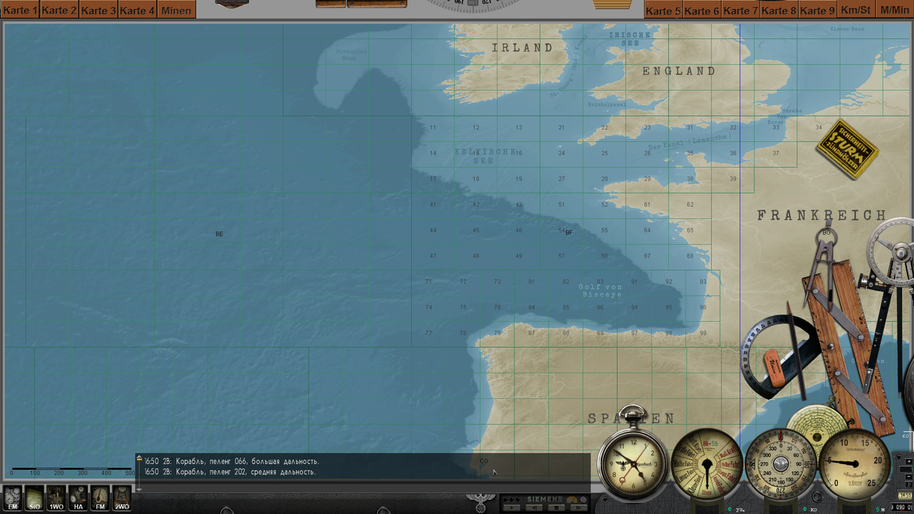 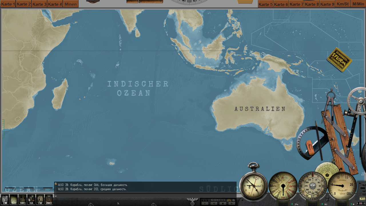 Download: https://drive.google.com/file/d/1EiS...ew?usp=sharing --------------------------------------------------------------------------------------------------------- --------------------------------------------------------------------------------------------------------- Navigation Bathymetry Map 2022 (Stock version 1.1) 07.06.2022 Depth has been changed in this update coastal waters of America. Starting from Georgetown and up the map, the Bay of Maine, coastal waters of Halifax, Nova Scotia, coastal waters of Newfoundland and Labrador, Great Newfoundland Bank bypassing Belle Isle Sound from the north and ending with Melville Lake. Changed all depths of the Gulf and the St. Lawrence River. It was not possible to change only the strait of Belle Isle for technical reasons. ----------------------------------------------------------------------------- I express my gratitude to the participant of the forum Subsim - Mornar Brane. This guy always took the time to answer my questions. and was a huge help in creating this version. ----------------------------------------------------------------------------- 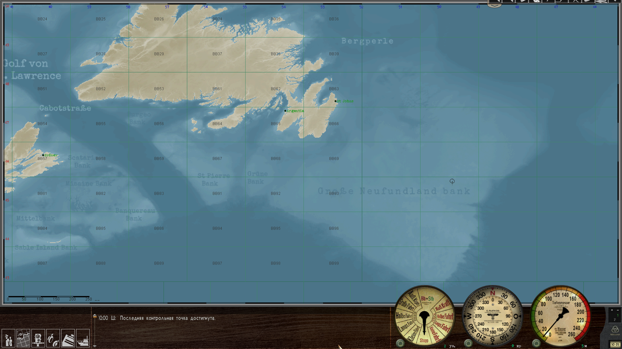 The mod is suitable for all versions of the game. Installation using the JSGME program. Download: https://drive.google.com/file/d/1Lwm...ew?usp=sharing ----------------------------------------------------------------------------- Navigation Bathymetry Map 2022 (Stock version 1.0) 17.04.2022 На карту добавлены подписи стран (как на стоковой карте конвоев), заливов, морей, океанов и морских банок. 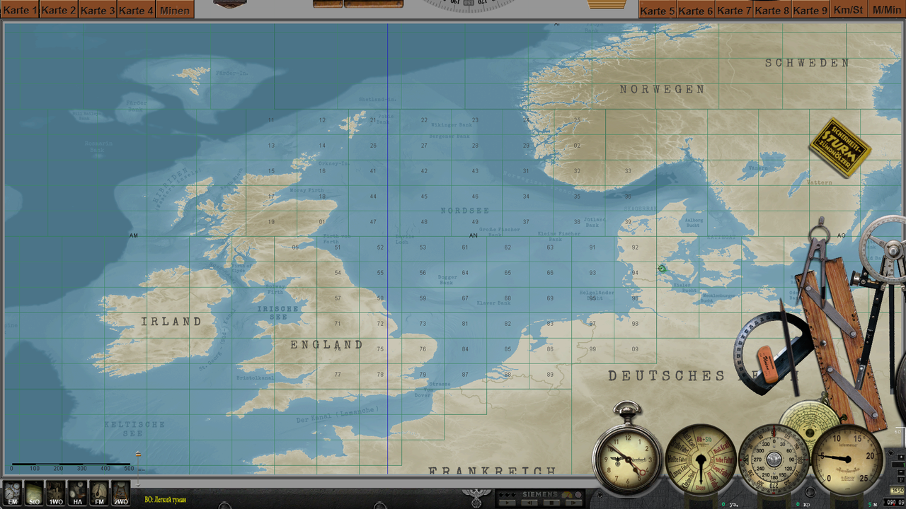 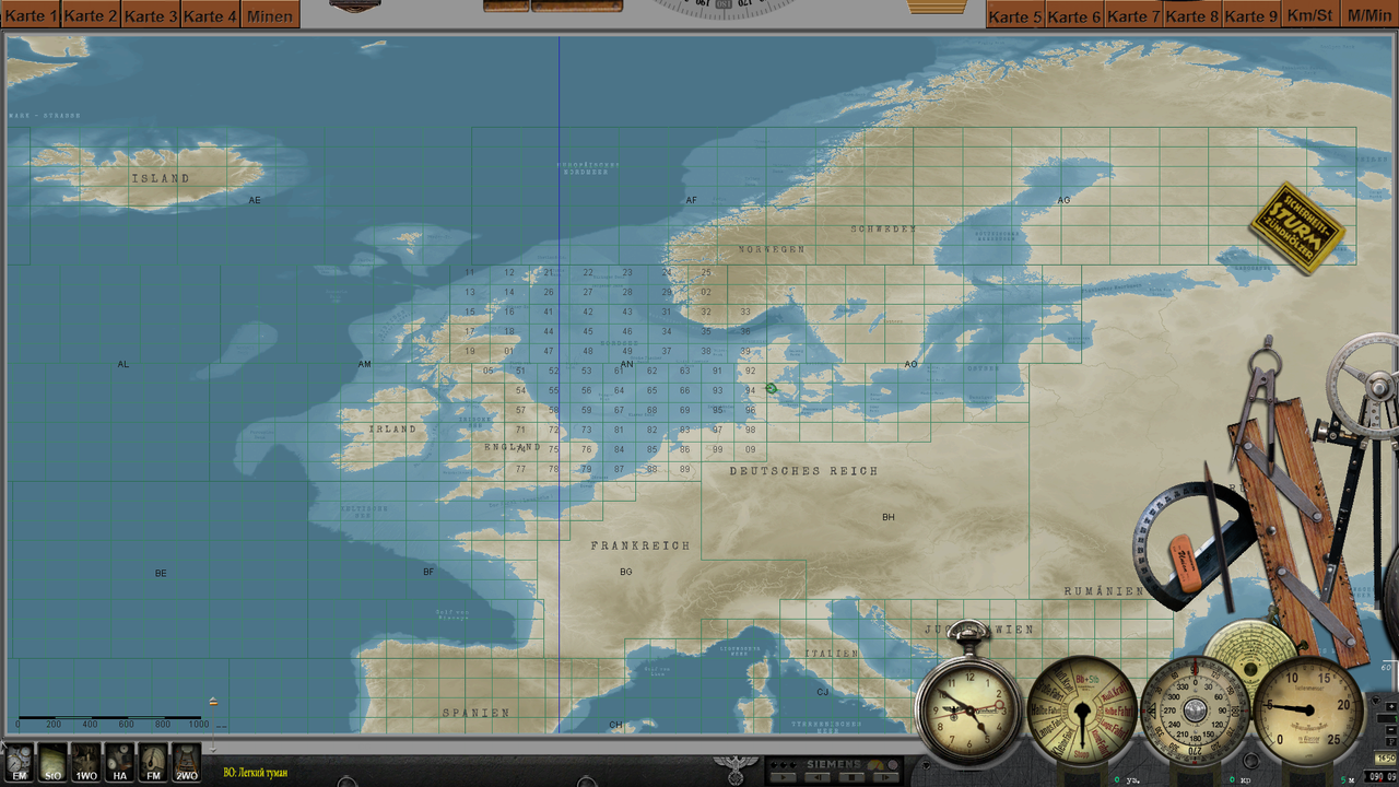 Мод карты подходит для любых версий разрешения экрана и для любых мод-паков и сборок. Установка: Через JSGME или просто замените файлы в корневой папке игры. Как вам будет удобно. Скачать: https://drive.google.com/file/d/1gjR...ew?usp=sharing ------------------------------------------------------------------------------------------------------------ Navigation "Bathymetry" Map 2022 (Stock version) 10-03-2022 Приветствую всех. Этот мод меняет глубины в игре и на навигационной карте на Максимально соответствующие Реальным. (с учётом возможностей и ограничений движка SH3) В первую очередь, он создавался для Модеров и их Модпаков. Уверен вы ребята, сможете адаптировать его под свои сборки (при желании) Отдельная благодарность за помощь в этом моде: Юрию Завражному (Filibuster60) Саня Собків (Onealex) Батиметрия построена программой SH3TerrainExtractor (автор ref) на основе данных с сайтов: – National Centers for Environmental Information https://www.ncei.noaa.gov/ – Bathymetric Data Viewer https://www.ncei.noaa.gov/maps/bathymetry/ ----------------------------------------------------- МАНУАЛ Полностью переделаны глубины: Балтийское море, Северное море, Ирландское море, Кельтское море, пролив Ла-Манш, Норвежское море, Баренцево море, Белое море, Азовское море, Черное море, Ионическое море, Средиземное море, Тирренское море,Балеарское море, море Альборан, пролив Гибралтар, Бискайский залив. Добавлены: 1 - Беломорско-Балтийский канал (Ладожское озеро, Онежское озеро, Выгозеро, водохранилище Ивинский разлив) 2 - Гёта-канал (озёра Венерн и Веттерн) 3 - Датские фиорды (Лим-фьорд, Ниссум-фьорд и Рингкёбингфьорд) 4 - Каледонский канал (Шотландия) 5 - Пять Великих Американских озер (озеро Верхнее, озеро Мичиган, озеро Гурон, озеро Эри, озеро Онтарио) P.S. На карте и в игре появились островки для постановки на них Маяков: Маяк Девичья Башня Маяк Ар-Мен МаякТевеннекский Маяк Фур Маяк Пилсум Маяк Стромболиккьо, Италия Маяк Фастнет Рок Скала Роколл Cкачать: Этот мод и все остальные мои моды, вы найдете на этой странице) https://brat01.mybb.rocks/viewtopic.php?id=210&p=3   Cкачать: Этот мод и все остальные мои моды, вы найдете на этой странице) https://brat01.mybb.rocks/viewtopic.php?id=210&p=3 --------------------------------------------------------------------------- Last edited by astvitaliy1982; 06-22-24 at 02:25 PM. |

|

|
|
03-10-22, 04:58 PM
|
#2 |
|
Captain
 Join Date: Sep 2011
Location: Halifax, Nova Scotia THE HUB OF ALL CONVOYS
Posts: 494
Downloads: 394
Uploads: 0
|
Ahh very nice, I was wondering if you would continue your work. I had your old version saved just in case but this is great news, more finalized version is always good. Keep up the great work, I use this with Onealex compilation through Jsgme.

__________________
U-Boote sind die Wölfe auf See...Angreifen...Reißen...Sinken!!! Submarines are the wolves at sea...Attack...Tear...Sink!!! - Karl Doenitz  Admin for the Onealex Mod Discord - https://discord.gg/bKCdQekE4W https://www.youtube.com/watch?v=tSpRvfqFYp0&t |
|
|
|
|
03-10-22, 09:15 PM
|
#3 | |
|
Grey Wolf
 Join Date: Feb 2021
Posts: 923
Downloads: 27
Uploads: 0

|
Amazing work !!!
 Quote:
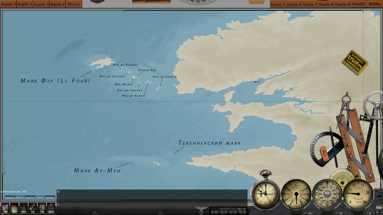
At this place, instead of an emerged island, it would be better to set a minimal depth (-12 m). --------------- 2. "Le Four" (Фур) lighthouse is misplaced on your map : https://www.subsim.com/radioroom/sho...&postcount=320 https://www.pharesdefrance.fr/carte-des-phares You pointed "La Jument" lighthouse, which is also not placed on an island : https://fr.wikipedia.org/wiki/Phare_de_la_Jument Last edited by Mister_M; 03-10-22 at 09:42 PM. |
|
|
|
|
|
03-11-22, 12:35 AM
|
#4 |
|
中国水兵
Join Date: Jun 2019
Posts: 270
Downloads: 558
Uploads: 0
|
1. В начале описания я написал -"с учётом возможностей и ограничений движка SH3". Нельзя ставить глубину -12м на местах установки маяков. Его некуда будет поставить.
2. Да, я увидел. Не Маяк Фур а Маяк Жюман. Спасибо что указали на это (на скриншоте). Last edited by astvitaliy1982; 03-11-22 at 01:23 AM. |
|
|
|
|
03-11-22, 08:15 AM
|
#5 | |
|
Grey Wolf
Join Date: Feb 2021
Posts: 923
Downloads: 27
Uploads: 0
|
Quote:
https://www.subsim.com/radioroom/att...9&d=1500242256 https://www.subsim.com/radioroom/att...2&d=1502834599 https://www.subsim.com/radioroom/att...4&d=1502907600 The lighthouse is attached on an underwater rock, and this rock is lying on the sea ground : https://www.subsim.com/radioroom/att...7&d=1500241339 Last edited by Mister_M; 03-11-22 at 08:40 AM. |
|
|
|
|
|
03-11-22, 01:45 PM
|
#6 | ||
|
Grey Wolf
Join Date: Feb 2021
Posts: 923
Downloads: 27
Uploads: 0
|
Quote:
 Quote:
 And this is a relatively high poly model with a medium quality texture... So it probably doesn't deserve to be included in any SH3 campaign in my opinion... You might have any ideas about that ? And this is a relatively high poly model with a medium quality texture... So it probably doesn't deserve to be included in any SH3 campaign in my opinion... You might have any ideas about that ?
|
||
|
|
|
|
03-11-22, 02:29 PM
|
#7 |
|
中国水兵
Join Date: Jun 2019
Posts: 270
Downloads: 558
Uploads: 0
|
Скорее всего у меня трудности с переводом с английского... Я так понял, вы почти закончили мод советской подводной лодки... Что такое AI в SH3?
|
|
|
|
|
03-11-22, 02:35 PM
|
#8 |
|
中国水兵
Join Date: Jun 2019
Posts: 270
Downloads: 558
Uploads: 0
|
Квадрат который вас интересует - W005N050. У меня есть его рабочая версия и я мог бы передать её вам. Если вы подскажите как это сделать...)
|
|
|
|
|
03-11-22, 03:12 PM
|
#9 | ||
|
Grey Wolf
Join Date: Feb 2021
Posts: 923
Downloads: 27
Uploads: 0
|
Quote:
Quote:
|
||
|
|
|
|
03-12-22, 12:28 PM
|
#10 | |
|
GLOBAL MODDING TERRORIST

Join Date: Sep 2014
Posts: 5,649
Downloads: 137
Uploads: 0


|
Quote:
|
|
|
|
|
 |
|
|


 Linear Mode

