
|
|
SUBSIM: The Web's #1 resource for all submarine & naval simulations since 1997
|
SUBSIM: The Web's #1 resource for all submarine & naval simulations since 1997 |
 02-01-08, 07:00 PM
|
#1 |
|
Captain
 Join Date: Jul 2006
Location: Washington State south of Tacoma
Posts: 494
Downloads: 26
Uploads: 0
|
We need better nautical charts that make available at least some sense of depth. Perhaps just a contour delimiting the 100 meter line along coastlines, but it would be nice to have some idea re: depths in shallower water without having to ping (sometimes in dangerous conditions). I am sure the Uboat commanders had nautical charts with at least minimal depth information. The nav map available is terribly insufficient (in many ways) and quite crude - devoid as we know of depth information except for faint coloration differences. Anybody know of a source of reasonably large scale maps that could be edited digitally with depth soundings (and free in the public domain, of course)? I've tried several sources but cannot find same. I realize the Lat/Long limitations of SH3 regarding real world azimuths, but coastlines would be reasonable accurate and congruent with the game. Perhaps someone could make a high quality scan of a representative coastline (East coast of England, West coast of Norway, for example) and we could add sounding data to it digitally, then upload it to the community as a test? The charts, as hardcopy, could reside outside the game, ie, not be accessed by some keystroke, to keep it simple.
Am using GWX v2 - great work, guys! |

|

|
|
02-01-08, 07:47 PM
|
#2 |
|
Ocean Warrior
 Join Date: Sep 2006
Location: Connecticut
Posts: 2,507
Downloads: 145
Uploads: 0
|
You know.. I thought about the same thing but I was unable to find any good sized maps to port in and also considering how crappy an artist I am, making one from scratch would be impossible.
I fully agree. The nav map we have is terrible. I'm colorblind so most of the ocean and the little depth color chart thing all look the same color to me so I can't tell depth at all. I'd LOVE to see some contour lines. My question is... Did they HAVE accurate depth maps back then for the Atlantic though ?
__________________
 Be my friend or be a mushroom cloud. Be my friend or be a mushroom cloud.  "I am coming at you. You will explode in a couple of minutes !" "I am coming at you. You will explode in a couple of minutes !"
|
|
|
|
|
02-01-08, 08:48 PM
|
#3 |
|
Eternal Patrol

 Join Date: Jan 2008
Location: Hiding on the bottom
Posts: 1,783
Downloads: 853
Uploads: 457

|
Good Question Captains. I just might start a throw away carrer and Run grids for depth and record them. Results may be a downloadable may with depth. I am not a modder so not much else to do except pull it from my knee pad.
|
|
|
|
|
02-01-08, 09:59 PM
|
#4 |
|
Navy Seal
 Join Date: Nov 2006
Location: Docked on a Russian pond
Posts: 7,072
Downloads: 2
Uploads: 0
|
Although the presentation is bad, especially if used to work with nautical charts, the SH3 chart does give you a rough idea of depth.
Sinse I stay out of shallow water, period, it doesn't bother me much. If I need to ping, I don't wait for the enemy to show up to start pinging.
__________________
Espionage, adventure, suspense, are just a click away Click here to look inside Brag's book: Amazon.com: Kingmaker: Alexey Braguine: Books Order Kingmaker here: http://www.subsim.com/store.html For Tactics visit:http://www.freewebs.com/kielman/  |
|
|
|
|
02-01-08, 10:08 PM
|
#5 |
|
Commander
 Join Date: Jan 2007
Location: Kent
Posts: 473
Downloads: 1
Uploads: 0
|
I may be wrong in this but I think that format was there in SH2. Or at least the depth contours were more defined.
__________________
The beauty of not planning is that failure comes as a complete surprise without any of the stress that might normally precede such a venture |
|
|
|
|
02-01-08, 10:19 PM
|
#6 |
|
Eternal Patrol

Join Date: Nov 2002
Location: High in the mountains of Utah
Posts: 50,369
Downloads: 745
Uploads: 249


|
In SH2 anywhere the cursor was on the map, the little screen would tell you the exact depth. Not realistic, but useful.
__________________
Never do anything you can't take back. Rocky Russo |
|
|
|
|
02-01-08, 10:35 PM
|
#7 |
|
Captain
Join Date: Jul 2006
Location: Washington State south of Tacoma
Posts: 494
Downloads: 26
Uploads: 0
|
Blacklight: I would be surprised if the Kriegsmarine, as it prepared for the coming strife, did not load up on reasonably accurate nautical charts of Great Britain, Scandinavia, USA, and the Baltic at least. Also remember, the German UBoots were active around the UK in the first war.
I should think that any digitally saved map of a decent size (maybe sector maps would be needed) could be marked-up simply to indicate depth contours, and no modding experience would be needed - just a test sub cruising along pinging as it went and the 'gamer' marking a hardcopy with decently (roughly) accurate data. Any first pass could be corrected by the community as time passed. Brag: Yes, very shallow waters are bad, but moving into the water off Dunkirk or off some harbors in England or Norway, it would be helpful to know the depth and how close you want to risk it before a DD shows up on the horizon, no? Sailor Steve/_mhara: Right, I forgot that. Not an option (popup screen) in SH3 I suppose, maybe one of the modding experts have an answer. If we get no reply here, we can take it to the SH3 Mod forum and see what we get. |
|
|
|
|
02-01-08, 10:40 PM
|
#8 |
|
Captain
Join Date: Jul 2006
Location: Washington State south of Tacoma
Posts: 494
Downloads: 26
Uploads: 0
|
One more thing to _mhara in response to his aphorism about failure...I remember another one, "The best preparation for failure is repetition."
|
|
|
|
|
02-02-08, 12:57 AM
|
#9 |
|
Engineer
 Join Date: Aug 2007
Posts: 205
Downloads: 7
Uploads: 0
|
I'm kind of fond of Homer Simpson's, "Everybody knows the first step toward failure is trying". :rotfl:
__________________
Spectre |
|
|
|
|
02-02-08, 11:03 AM
|
#10 |
|
Silent Hunter
  Join Date: Dec 2004
Location: AN9771
Posts: 4,904
Downloads: 304
Uploads: 0
|
One of the GWX devs (don't remember who) said that the AI cannot hear you depth-pinging. So I say, if you fear getting grounded, do it. I doubt real-life maps are going to help either because the SH3 world/map may not be in the same kind of projection as the real-life map. The only way that makes sense to be reliable in-game and historically aswel (the enemy was able to hear you ping depth) would be to do depth-pinging tracks in peace-time conditions (test mission generated with mission editor) and record the depths. But that's a hell of a work I wouldn't like to do. I can live with this cheat-ish way.
|
|
|
|
|
02-02-08, 11:20 AM
|
#11 |
|
Rear Admiral
 Join Date: Apr 2006
Location: Swindon, England
Posts: 10,151
Downloads: 35
Uploads: 0
|
No the SH3 world isnt the same as the real world
Will show you a way to get depths Zoom in on mission editor 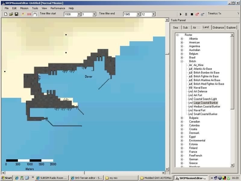 And select a land unit ( bunker ) and drag onto map to where you want to check depth The game automatically sets the land units onland - in this case the sea floor Note the depth highlighted  In this case -18m Try another in different spot 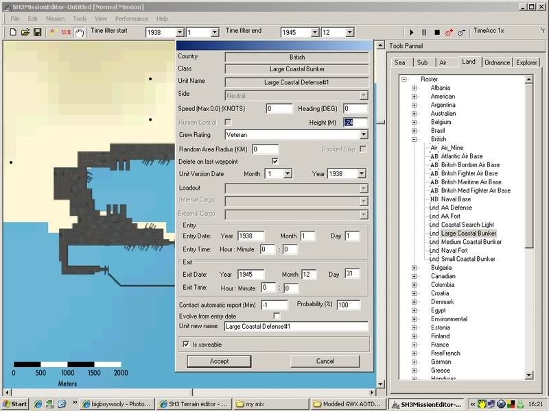 Minus 24m 
|
|
|
|
|
02-02-08, 11:26 AM
|
#12 |
|
Weps
 Join Date: Dec 2007
Location: MVD, UY
Posts: 359
Downloads: 7
Uploads: 0
|
Go for the dark blue spots

__________________

|
|
|
|
|
02-02-08, 12:16 PM
|
#13 | |
|
Silent Hunter
Join Date: Dec 2004
Location: AN9771
Posts: 4,904
Downloads: 304
Uploads: 0
|
Quote:
 That saves alot of ringing ears in the SH3 aquatic wildlife. That saves alot of ringing ears in the SH3 aquatic wildlife. Getting that depth-information onto a map usefull during play-time is still going to be cumbersome though. One way I'm thinking of is recordig the depth at certain regularly spaced map coordinates (shown in mission editor) and translate them to map-mark entries (Sh3Gen does that, so it's possible), to be placed in a savegame .map file. So you could insert a section of depth marks (a couple of patrolzones) inbetween saving and reloading. Example: Code:
[Mark] PointsNb=8 Pt0=-8633782,4342699,0,55m Pt1=-10432753,3458574,0,56m Pt2=-8546785,1983000,0,54m Pt3=-9723398,1771374,0,53m Pt4=783002,7719000,0,40m Pt5=4017525,8312201,0,42m Pt6=4021550,8422661,0,42m Pt7=4808148,7784480,0,41m ... Last edited by Pisces; 02-02-08 at 12:41 PM. |
|
|
|
|
|
02-02-08, 12:19 PM
|
#14 |
|
Rear Admiral
Join Date: Apr 2006
Location: Swindon, England
Posts: 10,151
Downloads: 35
Uploads: 0
|
Yes that way looks like it would work ok
The other way would be to add them onto the map itself |
|
|
|
|
02-02-08, 12:36 PM
|
#15 | |
|
Silent Hunter
Join Date: Dec 2004
Location: AN9771
Posts: 4,904
Downloads: 304
Uploads: 0
|
Quote:
And alt-tab-ing back and forth between mission editor and game is annoying, not to mention it's difficult to tell where to place the marks by hand ingame. Or am I missing something? |
|
|
|
|
 |
|
|


 Linear Mode

