
|
|
SUBSIM: The Web's #1 resource for all submarine & naval simulations since 1997
|
SUBSIM: The Web's #1 resource for all submarine & naval simulations since 1997 |
 09-05-08, 01:07 PM
|
#1 |
|
Ocean Warrior
 Join Date: Jan 2008
Posts: 2,909
Downloads: 77
Uploads: 11
|
EDIT: If anyone is looking at this and wondering where the maps are, it's because this is the WIP thread, there are two release threads:
http://www.subsim.com/radioroom/showthread.php?t=141812 for U.S. Subs http://www.subsim.com/radioroom/showthread.php?t=141977 for U-Boats, but works with U.S. Subs as well. Orginal message: Hello fellow subsimmers. I find the pastel shades of the standard map a bit hard to discern the gradients. Also there's no terrain height info with which to navigate by. I think nautical maps are generally only concerned with the depth of the ocean, not the height of the land, but with points of departure being used to plot departutre courses at the start of patrol, they must have used maps of the land that showed elevation as well as the sea depth? Anyway, is there any interest in a mod that changes the map's default colours? If so, what would you want them changed to? Here's the standard map: 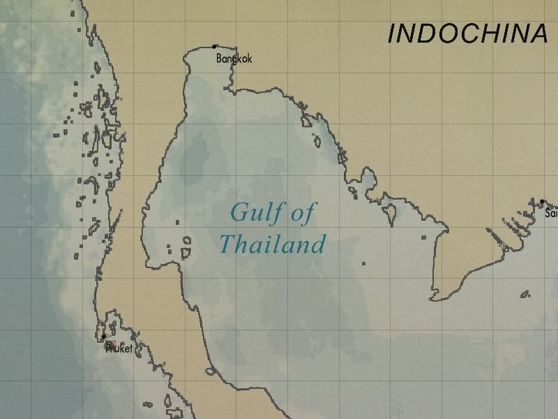 And here's what a new map could look like, note that height information has been added and the depth information is clearer:  Comments please!
__________________
-------------------------------- This space left intentionally blank. Last edited by Nisgeis; 09-21-08 at 02:08 PM. |

|

|
|
09-05-08, 01:25 PM
|
#2 |
|
Helmsman
 Join Date: Mar 2007
Posts: 101
Downloads: 14
Uploads: 0
|
I like the colors, the normal map is to gloomy for me and for sure I will download it when you finish it
 Good job. Good job.
|
|
|
|
|
09-05-08, 02:06 PM
|
#3 |
|
The Old Man
 Join Date: Apr 2008
Location: Huntington, Long Island, New York
Posts: 1,426
Downloads: 284
Uploads: 0
|
love it
|
|
|
|
|
09-05-08, 02:12 PM
|
#4 |
|
Watch
 Join Date: Jan 2006
Location: Estes Park, Colorado
Posts: 19
Downloads: 187
Uploads: 0
|
That's just great!
__________________
I don't know what your talking about Mr. Cartwright,....do you sir? "Kraut Mueller" Windows Vista Ultimate Core2Duo3.00GHz 2.00 GB Ram NVIDIA GeForce9800GT |
|
|
|
|
09-05-08, 02:25 PM
|
#5 | |
|
Ocean Warrior
Join Date: Jan 2008
Posts: 2,909
Downloads: 77
Uploads: 11
|
Quote:
__________________
-------------------------------- This space left intentionally blank. |
|
|
|
|
|
09-05-08, 03:06 PM
|
#6 |
|
Sea Lord
 Join Date: Aug 2007
Location: Too far from the Pacific right now...
Posts: 1,634
Downloads: 0
Uploads: 0
|
You might try cutting your blue colors with about 20-30% grey just to tone them down a bit...
__________________
RFB / RSRDC Beta Tester RFB / RSRDC Modding Forum: http://forum.kickinbak.com/index.php RFB Top Post link: http://www.subsim.com/radioroom/showthread.php?t=125529 RFB Loadout: RFB_V1.52_102408: RFB_V1.52_Patch_111608: RSRDC_RFBv15_V396 |
|
|
|
|
09-05-08, 03:27 PM
|
#7 | |
|
Ocean Warrior
Join Date: Jan 2008
Posts: 2,909
Downloads: 77
Uploads: 11
|
Quote:
What about the terrain elevation colours though? Yellow to dark brown is OK, or should it be yellow to dark green?
__________________
-------------------------------- This space left intentionally blank. |
|
|
|
|
|
09-05-08, 04:17 PM
|
#8 | ||
|
Mr. Bad Wolf

Join Date: Aug 2005
Location: Aabenraa, Denmark
Posts: 1,488
Downloads: 47
Uploads: 0
|
Quote:
 Though, I agree with the constructive criticism: reducing the contrast of the ocean colours a little would do fine. The way the terrain colours are presently is fine with me, but it's your call.
__________________
  Download my mods from SHMF Follow my photography here taler dansk, speak English, spreche Deutsch, parle français, forstår svenska/norsk, comprendo castellano |
||
|
|
|
|
09-05-08, 04:23 PM
|
#9 |
|
Admiral
 Join Date: Jan 2008
Location: New York State, USA
Posts: 2,390
Downloads: 126
Uploads: 7
|
Could you do polka dots?
I like the brown tones. I think the only part that catches my eye (and it may be my monitor) the water seems a little too "purple". Edit: I mean in the darkest parts, not overall. Peabody
__________________
System Spec: Gigabyte GA-965P-DS3, PentiumD Dual Core Presler 945 3.4Ghz, Gigabyte Geforce 7600GS, 2-1GB Corsair XMS2 800Mhz in Dual Channel, 2-WD 250 SATA 3Gb/s, Onboard Realtek HD 7.1 Audio, DVD ROM, DVD burner, Hiper 580 Watt Power supply, WinXP SP2. Last edited by peabody; 09-05-08 at 04:50 PM. |
|
|
|
|
09-05-08, 04:30 PM
|
#10 |
|
Lucky Jack
 Join Date: Jan 2006
Location: Down Town UK
Posts: 27,695
Downloads: 89
Uploads: 48


|
A vast improvement.
__________________
Dr Who rest in peace 1963-2017. To borrow Davros saying...I NAME YOU CHIBNALL THE DESTROYER OF DR WHO YOU KILLED IT! |
|
|
|
|
09-05-08, 04:55 PM
|
#11 |
|
Grey Wolf
 Join Date: Sep 2007
Posts: 921
Downloads: 75
Uploads: 0
|
I dunno. I think the devs got it pretty close
http://historicalresources.wordpress...-theater-maps/ Here's another 1942 map that was "top secret" at the time. http://www.pacificwrecks.com/airfiel...gatabu/map.jpg Try googling WWII "nautical chart" in images for more
__________________
"There are only two types of ships- submarines...... and targets" Unknown "you wouldn't catch me on a ship that deliberately sinks itself"- comment to me from a surface sailor. System: AMD 6300 3.5 GHz | 32GB DDR3 | SATA 300 320GB HD, SATA III 1TB HD, SATA III 1.TB HD | ASUS Sonar DS sound card NVIDIA 1660 Super OC | Windows 10 Last edited by swdw; 09-05-08 at 05:15 PM. |
|
|
|
|
09-05-08, 06:56 PM
|
#12 |
|
Planesman
 Join Date: Sep 2002
Location: Canada
Posts: 185
Downloads: 94
Uploads: 0
|
I like the land effects, though they may not be historically accurate. That said, the nautical charts I've seen tend to use progressivly darker blue the SHALLOWER the water gets. Deep water areas tend to be white.
__________________
 
|
|
|
|
|
09-05-08, 07:12 PM
|
#13 |
|
Stowaway
Posts: n/a
Downloads:
Uploads:
|
Love the idea of changing up the chart coloring. I spend a lot of time in RL working in marine navigation, and if you need any input, I would be glad to help.
An example of "modern" chart coloring is here: http://www.charts.noaa.gov/OnLineViewer/18721.shtml Most charts stick to the pastel shades because they are still discernable under red or blue lighting, which was commonly used to preserve night vision. Many different shades of blue to signify depth would wash out under blue lighting, which is why deeper water is white on modern charts. Not sure if anyone is interested or if I'm just babbling. Just in case you wanted to know. |
|
|
|
09-05-08, 08:34 PM
|
#14 |
|
Captain
 Join Date: Jan 2002
Location: Costa Rica
Posts: 527
Downloads: 145
Uploads: 0
|
I hope you also do the Atlatic Ocean for those of use that have two jobs (Nimitz/Doenitz, pls dont see this LOL)
Great Idea! BTW, expect me to do more posts... Im a torpedo man, not a medic
__________________
Pacific Thunder Campaing VIII-Retired www.subsowespac.org "Left on their own, engineers can be dangerous" |
|
|
|
|
09-05-08, 11:40 PM
|
#15 |
|
Captain
Join Date: May 2005
Location: Memphis, Tn. U.S.A.
Posts: 548
Downloads: 21
Uploads: 0
|
I also like the land effects, a real improvement over the stock in game map, hope you work out a solution for the ocean colors. Puts
__________________
" Is He?..........Yeah..........Nothing Moving, But His Watch." |
|
|
|
 |
|
|


 Linear Mode

