
|
|
SUBSIM: The Web's #1 resource for all submarine & naval simulations since 1997
|
SUBSIM: The Web's #1 resource for all submarine & naval simulations since 1997 |
 06-27-13, 08:23 PM
|
#1 |
|
Soundman
 Join Date: Nov 2012
Posts: 146
Downloads: 60
Uploads: 2
|
This is the first in a series on Coastal / Terrestrial Navigation, sometimes referred to as Piloting or Pilotage.
Warning: Long Post! How to do Running Fixes (or Versegelungspeilung) aka "Transferred Position Line" Also applicable to SH4 and SH5, method is the same... For those doing manual navigation, but are currently only doing dead reckoning plots, this may be of interest to you as something to add into the nav mix. There's probably plenty of you that do this already so apologies if I'm stating the obvious. This tutorial assumes you're already doing dead reckoning navigation at least (i.e. not using SH3 waypoints). If anything is unclear (it will be I'm sure) then please ask and I'll do my best to answer. Apologies that my images are a bit of a mess, if anyone wants a video tutorial for this, I'll make sure it's all neater and clearer. The Important Stuff Keep real pencil and paper notes! (obvious for manual navigating veterans) These fixes are only useful when land is within sight (and impossible when it's not), and ideally slightly more in sight than a "blur in a fog bank" that you'll get at around 9 maybe 10km away. When plotting any fixes that rely on visual aids, you need to bear the following in mind. SH3 maps don't mark landmarks like lighthouses, or buoys that real nav charts do, the first step is to find a clearly identifiable bit of land. Warning: this is more difficult than it sounds. Double check that what you're looking it is what you think it is. Inlets or islets are really good for this. Any point where there is a sudden shift in pixels... The pixelated nature of the landscape in SH3 works in our favour here as it means you can identify a corner or edge to consistently take measurements from. Plotting a Running Fix Obviously you need to have the sub icon removed from the nav map, which if you're already doing manual navigation you will have done already. (If not, shameless plug for my mini mod) 1. Draw your course line Your plotted course. Use the protractor to mark this from your known starting position. Tell you steuermann to get on it by giving him the relevant heading to follow. Make a note of your speed and keep it as cosistent as possible. (Again, obvious stuff). My example: A course of 337 so Helgoland passed on my port side, speed = 8kts. (Normally I'd note distance and ETA of the leg, but not important for this example) 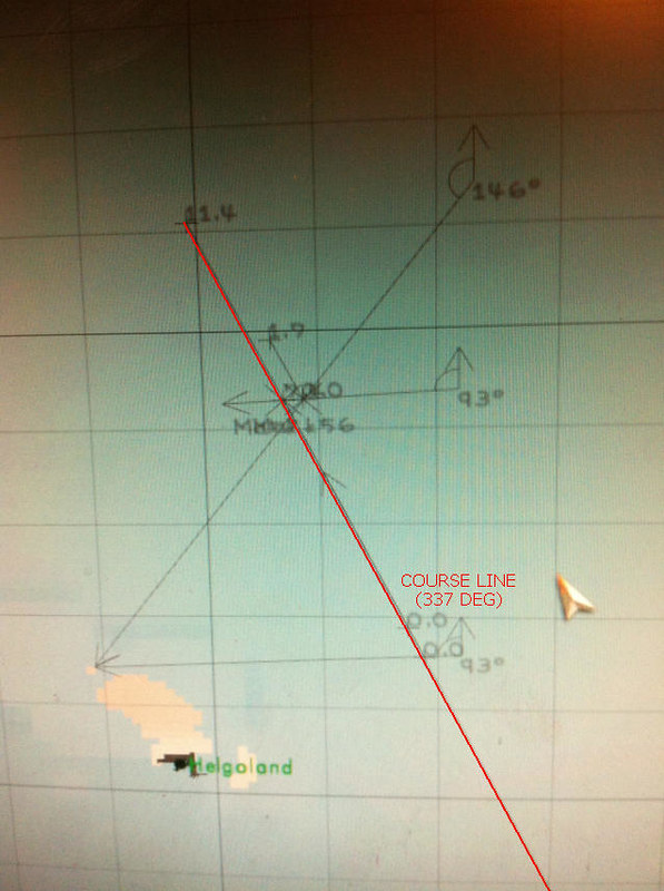 2. Pick your landmark and take a bearing (#1) Using periscope or UZO take a reading of the bearing of landmark of choice, (make sure it's still likely to be in range for second reading later...) and convert into True Bearing. Maths that may be obvious for some, but sharing to be helpful if not:-
Plot the bearing line onto navigation map using the protactor, so that it ends on the landmark you observed and crosses/bisects your course line. Where these lines cross is roughly where you boat is, but with only one "Line of Position" it's very rough. Any navigational fix requires at least two LOPs, so we carry on... My example: I took a bearing of the Helgoland north islet (Lange Anna?) of 267 (true bearing) at 1335. I marked this in SH3 by using the protractor to draw this angle so that it bisected my course line. 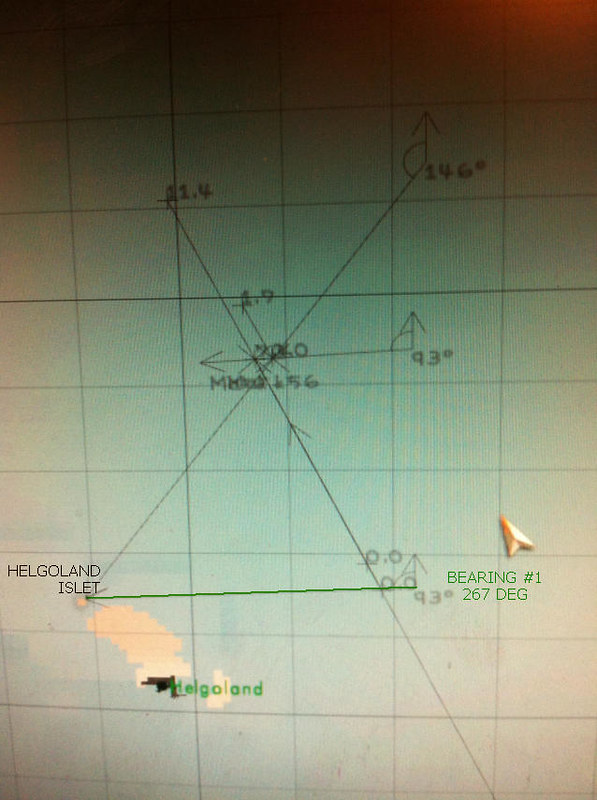 Note: It's much easier to draw the line from the observed point rather than to it.... But this means the angle labels become overlaid and obscured, but as long as you've written them down on paper, it doesn't matter. 3. Steam ahead for a bit then take a second bearing... (#2) I generally use intervals of 30 minutes (game time) between readings. So skip ahead 30 minutes and take a second bearing of the same spot. Plot this on the SH3 navigation map in the same way as in Step 2. My example: I took a bearing of 214 (true) at 1405 (making sure the UZO line up with the exact same edge/corner as previously) 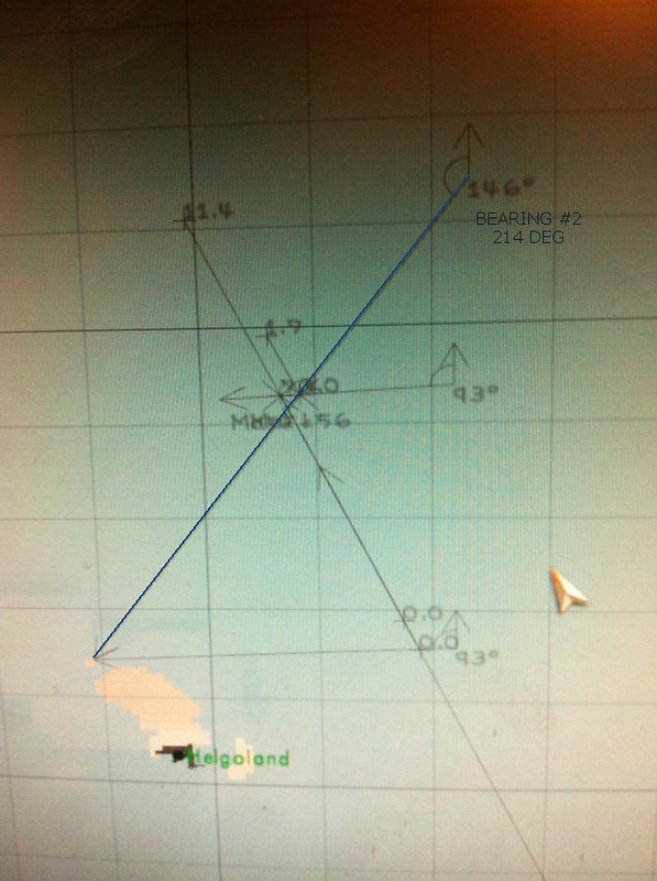 4. Work out distance travelled As you have noted your speed, you will know how far you should have travelled. Consulting the speed chart you can see that 8 knots is 14.82km/h - so in 30 minutes we should have travelled 7.41 km (round down to 7.4). Mark this exactly over the course line with the ruler, starting from the point where the first bearing line crosses the course line. The cross end of this ruler point is important, make sure it lines up over the course line as exact as possible. 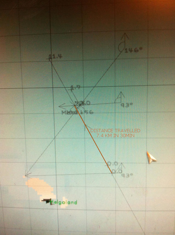 5. Transfer the first bearing line This is where it gets tricky. Using the protactor, you will need to redraw the first bearing angle so that it bisects the end of the ruler mark that you just made, and the second bearing line. This may take a few attempts (it took me a good 4 or 5 minutes the first time). If someone can mod a copy and paste function for map marks, it would be hugely appreciated (with a Parallel Rule icon :P) 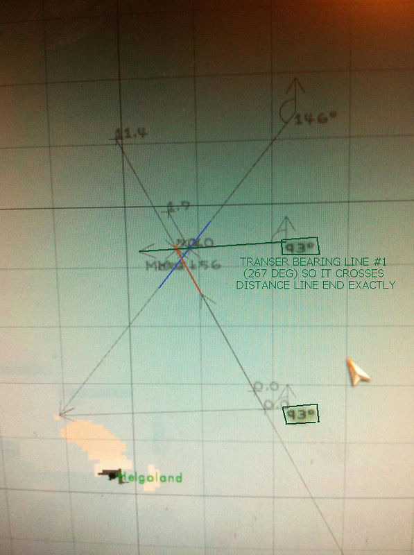 Where this new transferred first bearing line crosses over the second bearing line is the approximate position of your boat at the time you took the second bearing. Well done. If my waffle made any sense, you can now do Running Fixes. 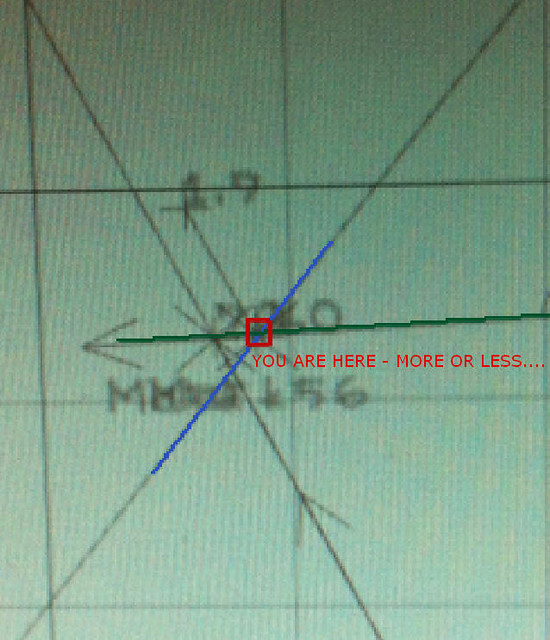 Note: There is an extra Dead Reckoning line on my screenshot as it took me a couple of minutes to transfer the line (and failing to get screenshots to work properly), so I had to compensate for that time when confirming my actual position (cheating :P). 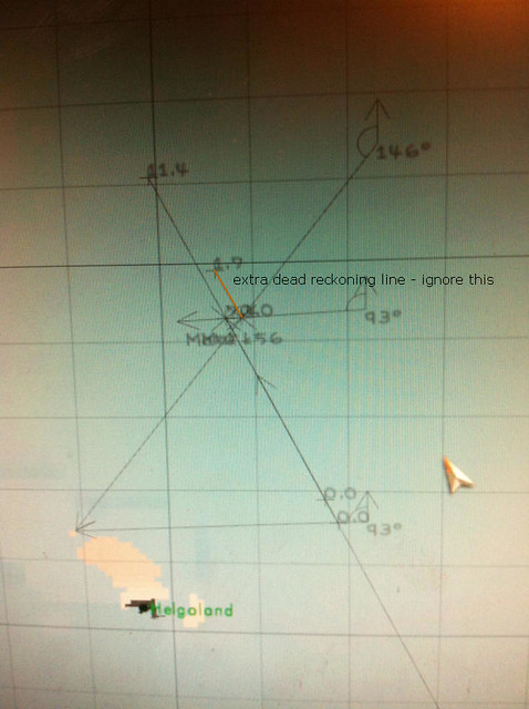 ~-~-~-~-~-~-~-~ Margin of error with this method, for me at least, is usually 200 metres (in calm waters), which is pretty decent. This type of fix will only ever be approximate. What I refer to as bearing lines should properly be called Lines of Position, or LOPs. The next step for is to make printable versions of the SH3 map so that I can do this with a parallel rule and pencil etc. Should be quicker than faffing about on the nav map in game. And more fun. I'm sure the old hands Next Time on Heinrich's Half Hour (well done if you got through that wall of text)
__________________
Die Südfrüchte runter vom Kartentisch. Auf Bananen kann ich nicht navigieren. Last edited by Karl Heinrich; 07-04-13 at 08:40 PM. |

|

|
|
07-03-13, 09:54 PM
|
#2 |
|
Lieutenant
 Join Date: Jan 2012
Posts: 252
Downloads: 66
Uploads: 0
|
I would like to ask how "Doubling Angle on Bow" works?
__________________
Robert Schmidt, LTJG U-43 |
|
|
|
|
07-04-13, 05:24 AM
|
#3 |
|
Soundman
Join Date: Nov 2012
Posts: 146
Downloads: 60
Uploads: 2
|
No problem, LemonA.
Again, "doubled angle on bow" is generally less accurate in coastal nav than two point (or more) cross fixes. But if you only have one landmark, it can be useful like running fixes (Although I prefer the latter). Again the most difficult thing is finding a clearly identifiable bit of land. The Actual Explanation Basically, you take a bearing of the landmark when it's at a nice round number (not essential of course) and under 45 degrees, e.g. 20 degrees. Plot this on the map across your dead reckoning course/track line. Note time and speed as always. Proceed along the set course and keep an eye on this landmark, when it reaches 40 degrees in this example, note the time and plot another position line. Consulting speed/distance charts calculate the distance travelled. In this case, say it's 12km. This works because it generates an isosceles triangle, so the distance between your boat and the second bearing taken is the same as the distance travelled. So 12km down the second bearing position line is where your boat is. If you're on couse this should pretty much be where the second bearing position line and your intended course line meet. The alternative is the Four Point Bearing - same procedure, but the first bearing must be taken at 45 degrees and the second at 90 degrees. ~~~ Apologies it's a bit of a rough explanation, I'll do a proper one with pretty pictures soon - for some reason the screenshot function in SH3 wasn't working before but is now. I'll put together some revised guides shortly, this one was a little more haphazard than intended. If I can get FRAPS working I'll do it as a video tutorial. If anyone knows to what extent wind affects position it would be appreciated, need to do more tests on this to calculate "set and drift". I know time compression affects speed as wel (but only in rough seas it seems), I recall Vanjast suggesting it was around 15% increase, and my single test so far has shown it to be 14% (so near enough). I'm also planning a world and map mod that adds more notable landmarks (lighthouses etc). to the landscape - assuming this is feasible. The intention is to focus on a relatively small area first. Where possible these will be historically accurate
__________________
Die Südfrüchte runter vom Kartentisch. Auf Bananen kann ich nicht navigieren. Last edited by Karl Heinrich; 07-04-13 at 10:32 AM. |
|
|
|
|
07-04-13, 10:52 AM
|
#4 |
|
Lieutenant
Join Date: Jan 2012
Posts: 252
Downloads: 66
Uploads: 0
|
How does it works here?
Course 303 t, speed 8 kts 1. bearing to landmark: 281 rel calculation... 281 * 2 = 562 = 202. But waiting for 2. bearing 202 rel is not successfull.
__________________
Robert Schmidt, LTJG U-43 |
|
|
|
|
07-04-13, 10:55 AM
|
#5 | |
|
Lieutenant
Join Date: Jan 2012
Posts: 252
Downloads: 66
Uploads: 0
|
Quote:
__________________
Robert Schmidt, LTJG U-43 |
|
|
|
|
|
07-04-13, 08:20 PM
|
#6 |
|
Soundman
Join Date: Nov 2012
Posts: 146
Downloads: 60
Uploads: 2
|
Apologies, my explanation wasn't clear, I rushed it.
You wouldn't be able to take a bearing at 281 as that's a relative angle of 79 degrees (if you found yourself seeing something for the first time at that bearing, then you could use the Transferred Position Line in the main post  ) ) For Doubled AOB it needs to be less than 45 degrees for it to work - and no less than 10 degrees ideally - best results are at around 30 degrees I find. So on the port side, you can take the first readings from relative bearings 316 up to 350 and on the starboard side 10 to 44. So it's not the bearing that you need to double but the angle. I know it's my fault for not making that clear before. Part of the confusion being what is meant by relative bearing. So a relative bearing of 330 is an angle of 30 degrees, so it's double is (obviously) 60 degrees which is a relative bearing of 300. Pretty Pictures and Example (I find it much easier to explain with images) So in this example, I plotted your course the same as your example, 303T. 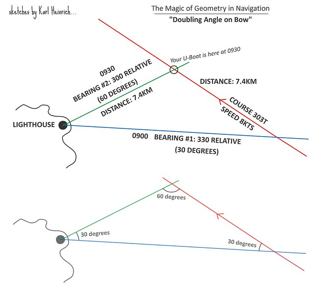 As always it's important to keep your speed and heading constant (I know you already know this LemonA). Through the UZO or 'scope, you spot a lighthouse ahead. You wait till you know you will get a good bearing for a fix. At 330 relative bearing on the UZO/Scope you plot the position line on the map and note the time - 0900 GMT. As this gives you 30 degrees AOB to the lighthouse, you keep checking till you have 60 degrees AOB to the lighthouse - relative bearing of 300 (on the UZO/scope reading). Travelling at 8kts, this takes you 30 minutes - consulting the charts tells you that you have travelled 7.41 KM. You've plotted this on your map and this gives you a nice isosceles triangle - so you know you have two lines of equal length - we know the distance from bearing #2 to your position is the same as the distance travelled along the course. Check bearing line #2 against your log, you know you've travelled 7.4 km so check with the ruler that bearing #2 is 7.4 km. If you've stayed on course this should be where line #2 and your course line meet. If not, then you are roughly where your ruler line ends at 7.4km... I feel like I've made this even more complicated now, I really hope it makes sense. You can also do it where the first bearing is 45 degrees AOB and the second 90 degrees AOB, that's slightly more accurate generally. -------- As I said, I planned to do a proper tutorial for this too... Trying to translate certain RL things to SH does need a bit of tweaking doesn't it, it's almost impossible to take compass bearings as you would IRL unfortunately. With this it's much easier to work out the "relative bearing" without ambiguity. On the plus side of course we know in SH magnetic north = true north so no need to calculate for magnetic deviation.
__________________
Die Südfrüchte runter vom Kartentisch. Auf Bananen kann ich nicht navigieren. Last edited by Karl Heinrich; 07-06-13 at 07:18 AM. |
|
|
|
|
07-04-13, 08:53 PM
|
#7 |
|
Lieutenant
Join Date: Jan 2012
Posts: 252
Downloads: 66
Uploads: 0
|
Found "Double the Bow" formula:
AoB_2 = AoB_1 + (180 - (2*AoB_1)) , if AoB_1 < 90 not available , else with AoB_1 is first AoB shot and AoB_2 is second AoB shot. Example: AoB_1 = 13 AoB_2 = 13 + (180 - (2*13)) = 167
__________________
Robert Schmidt, LTJG U-43 |
|
|
|
|
07-04-13, 09:05 PM
|
#8 |
|
Soundman
Join Date: Nov 2012
Posts: 146
Downloads: 60
Uploads: 2
|
That seems needlessly complicated lol. That looks like a TDC targetting formula. We just need to count down or up from 360/0.
IRL you'd point a compass at the lighthouse and subtract the compass bearing from your heading to get the appropriate relative bearing. So on a heading of 303T we point the compass at lighthouse, compass says 283. 303 - 283 = 20. So we know we need a second reading when it's 40, working backwards 303 - 40 = 263. Doesn't work quite the same in SH but the principle is the same of course.
__________________
Die Südfrüchte runter vom Kartentisch. Auf Bananen kann ich nicht navigieren. Last edited by Karl Heinrich; 07-04-13 at 09:16 PM. |
|
|
|
|
07-04-13, 09:14 PM
|
#9 | |
|
Lieutenant
Join Date: Jan 2012
Posts: 252
Downloads: 66
Uploads: 0
|
Quote:
__________________
Robert Schmidt, LTJG U-43 |
|
|
|
|
|
07-04-13, 09:22 PM
|
#10 | |
|
Soundman
Join Date: Nov 2012
Posts: 146
Downloads: 60
Uploads: 2
|
Quote:
I have tried doing vague bearings from the compass on the bridge though, good for confirming bearings but bloody useless if you want anything precise lol.
__________________
Die Südfrüchte runter vom Kartentisch. Auf Bananen kann ich nicht navigieren. |
|
|
|
|
|
07-04-13, 09:37 PM
|
#11 | |
|
Lieutenant
Join Date: Jan 2012
Posts: 252
Downloads: 66
Uploads: 0
|
Quote:
Maybe you add to your list also "Danger bearing", a fundamental coastal navigation method.
__________________
Robert Schmidt, LTJG U-43 |
|
|
|
|
|
07-04-13, 09:51 PM
|
#12 | |
|
Soundman
Join Date: Nov 2012
Posts: 146
Downloads: 60
Uploads: 2
|
Quote:
I'd not included danger bearings as SH3 doesn't simulate enough detail to warrant them (shoals etc), at least not in my experience which I know is rather less than many here. So if you're going to crash into land it should be hard to miss, otherwise you deserve to... I suppose it might be worth including for submerged navigation and night-time running. I'll leave it till last though, for the most part in SH just applying common sense is the easiest way to go of course
__________________
Die Südfrüchte runter vom Kartentisch. Auf Bananen kann ich nicht navigieren. Last edited by Karl Heinrich; 07-05-13 at 05:52 AM. |
|
|
|
|
|
07-06-13, 04:42 AM
|
#13 |
|
Soundman
Join Date: Nov 2012
Posts: 146
Downloads: 60
Uploads: 2
|
What I might also do, although it's rather time consuming, is create soundings data on the in-game map (with printable versions too) - obviously this will have to be done in rather small areas at a time. And based on contemporary KM charts - we won't get anything that they didn't have.
__________________
Die Südfrüchte runter vom Kartentisch. Auf Bananen kann ich nicht navigieren. |
|
|
|
|
07-06-13, 05:45 AM
|
#14 |
|
Admirable Mike

Join Date: Mar 2004
Location: Canada
Posts: 1,313
Downloads: 421
Uploads: 0
|
Thank you for your work.
Not only is it useful in game, but also to understand concepts and terminology such as relative bearing. I also use a technique for setting an intercept course on a radio announced contact. I use the ruler to run their course line forward and another ruler line to that line from my position. Of course I have to ask the navigator to do a fix to get that position. (Using TDW Real Navigation mod) Then I determine when I and they will reach the crossing point, using an estimate of their speed. To shorten that time I move along their course line, drawing added lines to my point. Each new line changes the distance I must move and so the time to arrive. Eventually I will get an optimum time to contact without needing a ridiculous speed on my part. Then I set course and speed to reach their location and go hunting. (The above is open water navigation, just related to what you discussed.) |
|
|
|
|
07-18-13, 06:00 AM
|
#15 |
|
Soundman
Join Date: Nov 2012
Posts: 146
Downloads: 60
Uploads: 2
|
Really glad you found it useful Raymond. Hopefully I can do "proper" tutorials and convert the terminology to SH better.
The method you describe there looks pretty spot on as far as real life goes My long term plan really is to add more tools and map / coastline features so it becomes practical to do manual navigation (the key think is to get the steuerman to stop being quite so drunk in calm weather, he's all over the place if you don't gave him a proper waypoint). All this combined with some of the celestial breakthroughs going on at the minute should hopefully mean full manual navigation will become a relatively straightforward reality.
__________________
Die Südfrüchte runter vom Kartentisch. Auf Bananen kann ich nicht navigieren. |
|
|
|
 |
| Tags |
| navigation, plotting, real navigation, running fix, running fixes |
|
|


 Linear Mode

