
|
|
SUBSIM: The Web's #1 resource for all submarine & naval simulations since 1997
|
SUBSIM: The Web's #1 resource for all submarine & naval simulations since 1997 |
 08-15-15, 11:23 PM
|
#1 |
|
Silent Hunter
 Join Date: Sep 2010
Posts: 3,975
Downloads: 153
Uploads: 11
|
|

|

|
|
08-15-15, 11:31 PM
|
#2 |
|
A-ganger
 Join Date: May 2009
Location: North Carolina
Posts: 77
Downloads: 65
Uploads: 0
|
*brain melts*

__________________
"Damn the torpedoes! Four bells, Captain Drayton, go ahead! Jouett, full speed!" -Rear Admiral David Farragut, Battle of Mobile Bay, Alabama, August 5, 1864 |
|
|
|
|
08-16-15, 07:22 AM
|
#3 |
|
Navy Seal
 Join Date: Mar 2007
Location: DeLand, FL
Posts: 8,899
Downloads: 135
Uploads: 52


|
It is also arbitrary. Saying that an area which is searched will not be counted because we don't want it is just arbitrary. It is searched, therefore it contributes the the result. Also, the wedge areas are not researched areas, they are as if they had not been searched at all the second time through because there is a time element here as well. Since you are spending double the amount of time in the wedge and enemy traffic is moving randomly within constraints of traffic patterns there is actually a higher percentage chance of obtaining a target in the wedge than outside the wedge. It is not only your movement that is important, but the movement of traffic into your search area. It is not coherent as you have assumed and they all don't line up side to side in a single line across your search area as you have assumed. They are distributed randomly throughout the area and are moving in randomized directions, yes, constrained by limits but random within those limits.
So while your math is admirable, your premises are questionable. The area searched each day is actually a rectangle based on the width of area searched and the end points of travel PLUS a circle of search radius around the sub. Assuming homogeneous distribution of shipping, your number of targets developed is directly proportional to the length of travel per day times the diameter of your search distance circle, plus the area of that search circle, half of which is added to your search area at the beginning of the day and half to the end of the day. That makes your search area a long hot dog. The longer your travel during the day the more contacts you will develop, nearly proportional to your speed. I say nearly because of what you're going to say next, which is that if your were entirely stationary, shipping would still enter your area because of their velocity and it would be as if you were moving against the velocity of their travel at their speed. That makes contacts found not exactly proportional to distance traveled in a day. It is conceivable if you park at a choke point you could have enough business that it wouldn't matter if you could develop more business because it takes time to deal with each contact. But ignoring random effects and choke points, your number of contacts is nearly proportional to the length of your track during each day. Now that is contacts per day. You want best results for a cruise. Best fuel economy is 11 knots. WFO is 21 knots, which would double your results. But at WFO your fuel consumption is many times the double search coverage, therefore your patrol contacts actually drop off the proverbial cliff. Therefore, searching on the surface so you can use radar at 11 knots is by far the best way to search. Yes, we could quantify that more precisely. We could toss the actually variable density of traffic in there to modify our path to more productive areas, and I hope we're already doing that. But the numerical results won't change our behavior at all. Our results and the calculated results will always be different from reality because our assumptions are wrong. We know that but not knowing the actual distribution of shipping, we have to generalize. We are not in total control of our destiny. We are card counters at a blackjack table, numbers on our side but knowing that we can still lose. You can do everything right and still lose. But you can only win if you do the right things......unless......
__________________
Sub Skipper's Bag of Tricks, Slightly Subnuclear Mk 14 & Cutie, Slightly Subnuclear Deck Gun, EZPlot 2.0, TMOPlot, TMOKeys, SH4CMS Last edited by Rockin Robbins; 08-16-15 at 07:34 AM. |
|
|
|
|
08-16-15, 01:34 PM
|
#4 |
|
Captain
 Join Date: Aug 2009
Posts: 481
Downloads: 71
Uploads: 3
|
So here's my take on this, and I would encourage further thought or debate on its merits.
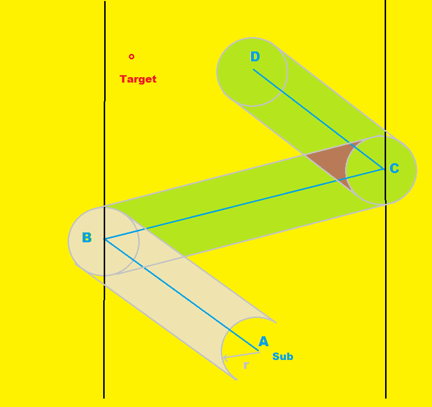
So suppose, for example sake, that you are patrolling a suspected shipping lane that runs north-south. Consider, that nearly every merchant target moves at a speed of 11 knots or less (usually slower). Let's further assume that your sensors have a reliable detection range of 13 miles (this is my experience for SJ-1 radar in TMO). Let's also assume that you want to patrol at a cruising speed of 10 knots. So, to ensure that no target heading north or south gets past you, the best course of action is to patrol strictly perpendicular to the shipping lane. If your sensor has a detection radius of 13 miles, it will take a 11 knot target 141 minutes to pass through it completely, meaning that you must be back at your original position within 140 minutes or so. During your patrol, you must turn 180 degrees twice, taking a total of 7 minutes, leaving a total cruising time of 133 minutes. (may vary by boat, mods, etc. accurate for a balao doing 10 knots in tmo though) Each leg of the cruise then becomes a 66 minute cruise at 10 knots, for about 11 nautical miles each way. In this case, it is certain that no target moving at a speed no greater than 11 knots can pass through a 11X26 mile box (286 square nautical miles). Additionally, on the west and east ends of the box, there is a 13 mile radius semicircle of detection. A 11 knot target may not pass through most of either of these areas without detection either. The sole part of the patrol area that a target may pass through undetected would be a segment of the circle defined by a 13 mile cord running north-south at the far end of the circle, an area of 88 miles. This works out to guaranteed detection of any 11 knot targets passing through an area of 641 square nautical miles (with an additional less than 100% chance of detection over 176 square miles as below) vs 531 if you had remained stationary or a 17% increase. Inside of this small segment, the odds of detection depend on target speed, and are directly proportional to the resulting length of chord. For example, the odds of detecting an 11 knot target passing through a north-south chord of 6.5 miles would be 50%. I thought it might be helpful to include a diagram of what I'm talking about.  With other sensors, the amount of time you can spend moving east-west will be reduced proportionally. For example, suppose that your detection radius is half of the SJ-1 range, or 6.5 miles. This would reduce the cruising time of each patrol leg by half. If you are willing to accept a less than 100% chance of detecting a 11 knot target, lets say guaranteeing detection of 9 knot targets instead, the amount of time spent on each leg of the patrol would then be increased proportionally. That would increase the length of each leg to 13.75 miles, with a 100% chance of detecting targets doing 9 knots.
__________________
My SH4 LP Last edited by ColonelSandersLite; 08-16-15 at 01:42 PM. |
|
|
|
|
08-16-15, 04:50 PM
|
#5 |
|
Ace of the Deep
 Join Date: Feb 2007
Location: Adelaide, Australia
Posts: 1,046
Downloads: 340
Uploads: 1
|
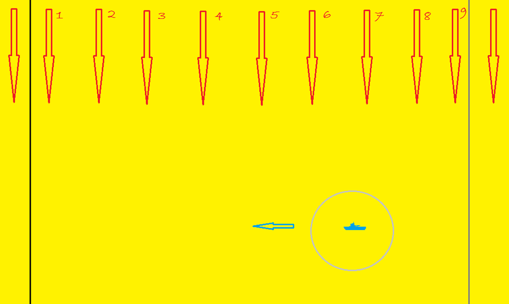
All great examples but how does it apply to a simulation that spawns ships at certain points on the map?
__________________
Fearless  System Specs: AMD Ryzen 7 5800X 8 Core 16 Thread CPU, 3.8GHz Base Clock, 4.7GHz Boost, 105W TDP, 32MB L3 cache | MSI GeForce RTX3060Ti 8Gb Graphics | Corsair Vengeance RGB Pro 32Gb (2x16Gb) 3200 MHz CL16 DDR4 Ram | Samsung 970 Evo Plus NVMe SSD 1TB | Seagate Barracuda 2.5in 2TB HDD | AOC QHD 165 Hz FreeSync HDR curved 31.5in Monitor | ASUS ROG Strix LC 240 ARGB AIO Liquid CPU Cooler White Edition | ASUS ROG Strix Gold 750W Modular Power Supply | Corsair iCUE 5000X RGB Tempered Glass Mid Tower Case White. |
|
|
|
|
08-16-15, 05:18 PM
|
#6 |
|
Watch Officer
 Join Date: Dec 2014
Location: Kansas City, Missouri
Posts: 343
Downloads: 24
Uploads: 0
|
I was not aware that ships spawn randomly - I thought their spawning and routing was encoded in the campaign files
__________________
"The sea shall ride over her and she shall live in it like a duck" ~John Ericsson |
|
|
|
|
08-16-15, 05:47 PM
|
#7 |
|
Captain
Join Date: Aug 2009
Posts: 481
Downloads: 71
Uploads: 3
|
Crannogman has it right. The ships aren't just a random distribution. They spawn at and despawn at ports. Not actually at the docks, but fairly close.
The big exception is the set piece battles, like midway. They spawn a *long* way from the battle, but not actually in ports. The do go to ports when their part is done though. I'm just guessing here, but I suspect that getting the timing of the ship movements for the battles down perfectly was just too much work when spawning them all the way back at port. If you want to see for yourself, open up the .mis files with the editor. They are in "\sh4\Data\Campaigns\Campaign". The yellow diamonds are spawn points. As an aside, I have never gone out of my way to watch any of those set piece battles. I really should one of these days. The only time I've actually seen one by pure chance was in SH3+GWX. I was harbor raiding during the invasion of norway and all of a sudden, some german surface vessels showed up and starting shooting everything. At first I thought they where enemy destroyers bearing down on me and shooting at my periscope the way destroyers do in these games...
__________________
My SH4 LP |
|
|
|
|
08-16-15, 05:58 PM
|
#8 | |
|
Navy Seal
Join Date: Mar 2007
Location: DeLand, FL
Posts: 8,899
Downloads: 135
Uploads: 52
|
Quote:
__________________
Sub Skipper's Bag of Tricks, Slightly Subnuclear Mk 14 & Cutie, Slightly Subnuclear Deck Gun, EZPlot 2.0, TMOPlot, TMOKeys, SH4CMS |
|
|
|
|
|
08-16-15, 06:00 PM
|
#9 |
|
Captain
Join Date: Aug 2009
Posts: 481
Downloads: 71
Uploads: 3
|
Oh, I may have a critical error in the post #4 above. I'll have to think on it some more later though. Gonna head to the range. I may get a chance to think it through tonight, but it might be tomorrow before I get to it.
Edit: I see RR posted something while I was typing that. He agrees with me, so I know it's got to be wrong  . .
__________________
My SH4 LP |
|
|
|
|
08-16-15, 06:03 PM
|
#10 | |
|
Navy Seal
Join Date: Mar 2007
Location: DeLand, FL
Posts: 8,899
Downloads: 135
Uploads: 52
|
Quote:
Now if you're coming up with a specific way to game RSRDC then, since I haven't looked at the campaign files, you might have a way. But I choose not to game the system and not to analyze the campaign files to get dates of departure, exact route and timing. The real sub skippers didn't have that information and I consider that if we use historical information to game the game we've broken the simulation irretrevably ourselves.
__________________
Sub Skipper's Bag of Tricks, Slightly Subnuclear Mk 14 & Cutie, Slightly Subnuclear Deck Gun, EZPlot 2.0, TMOPlot, TMOKeys, SH4CMS |
|
|
|
|
|
08-16-15, 06:12 PM
|
#11 | |
|
Navy Seal
Join Date: Mar 2007
Location: DeLand, FL
Posts: 8,899
Downloads: 135
Uploads: 52
|
Quote:
__________________
Sub Skipper's Bag of Tricks, Slightly Subnuclear Mk 14 & Cutie, Slightly Subnuclear Deck Gun, EZPlot 2.0, TMOPlot, TMOKeys, SH4CMS |
|
|
|
|
|
08-16-15, 09:35 PM
|
#12 |
|
Silent Hunter
Join Date: Sep 2010
Posts: 3,975
Downloads: 153
Uploads: 11
|
Ok, I haven't read all the comments and criticisms yet. I want to finish the problem and add a little math first. I'll try to get back to the comments, as time permits. 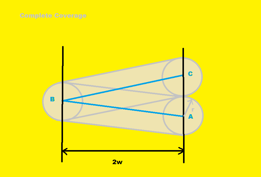 To achieve this level of coverage, our sub must go across the zone to the west and back again, so the detection circles at A and C are tangent. Mathematically, this means the sub must move the length of 4w in 't' hours, while the target ship moves 2r in 't' hours:From here, all we need to do is solve the second equation for t and substitute the result in the first equation. Doing this, we obtain: Last edited by TorpX; 08-17-15 at 01:33 AM. Reason: Added brief explanation for table |
|
|
|
|
08-16-15, 10:09 PM
|
#13 | |
|
Watch Officer
Join Date: Dec 2014
Location: Kansas City, Missouri
Posts: 343
Downloads: 24
Uploads: 0
|
Quote:
It seems that a formula will be forthcoming to calculate a minimum average speed "x" to patrol a chokepoint of width "y," variable of course on the range of your sensors. Another formula could tell you your miss percentage based upon how far below "x" you go (if, as TorpX posited, "x" is impossible or overly inefficient). Since RSRDC includes the variable waypoints, your detection chance is probably improved since ships will generally not be sailing in a direct line from origin to destination - thus it will take them longer to transit your patrolled box
__________________
"The sea shall ride over her and she shall live in it like a duck" ~John Ericsson |
|
|
|
|
|
08-16-15, 10:52 PM
|
#14 | ||||
|
Silent Hunter
Join Date: Sep 2010
Posts: 3,975
Downloads: 153
Uploads: 11
|
Quote:
You have to make some assumptions to solve the problem. Otherwise all you can do is speculate and theorize. I freely admit that traffic will not always be traveling alone a single axis, but frequently much of it will be. If you want to calculate a comprehensive figure for X% going N-S, and Y% going E-W, you can break the problem down in cases and do that. I am assuming a best case situation (for the sub), where they do know the axis of traffic. It is certainly possible to have the traffic on a different axis, not perpendicular, but I wanted to show what the best possible results would be. Quote:
The wedge areas overlap and you must account for this or the results are not correct. You are ignoring the fact that in diagram 2, I have subtracted the vector velocity of the target from both target and sub (I.e. different frame of reference). In diagram 2 the target does not move. To say that simply moving fast without regard to this fact, would be like expecting if you went very fast in a small circle, you would still get lots of contacts. By the same token, moving fast parallel to shipping will not avail you anything. Quote:
The expressions I have posted use the target's speed and it is expressly mentioned in the text. In fact, that is the whole basis of the computation. If you look over the results in the table, you will see, that increased sub speed does help with the chances, just not as much as some might expect. Also, a 3 kn. sub vs. a 6 kn. ship will give the same results as a 6 kn. sub and a 12 kn. ship. Iow, it is the ratio of sub speed to target speed that is important. Quote:
Last edited by TorpX; 08-17-15 at 01:47 AM. Reason: added paragraph at *** |
||||
|
|
|
|
08-17-15, 03:18 PM
|
#15 |
|
Captain
Join Date: Aug 2009
Posts: 481
Downloads: 71
Uploads: 3
|
Yeah, I did make a major mistake above. The boundary that I had previously called the guaranteed detection line is actually the 50% line. The line I have previously called the 50% line is actually the 25% line. Notice that this would be defined by a logarithmic function. The 100% line would be where the north/south @11knts contact moves just under 26nm except for the fact that radar coverage at both ends of the patrol zone extend past this. Apparently, I need to put more thought into this problem.
__________________
My SH4 LP |
|
|
|
 |
| Tags |
| math, operations, searching |
|
|


 Linear Mode

