
|
|
SUBSIM: The Web's #1 resource for all submarine & naval simulations since 1997
|
SUBSIM: The Web's #1 resource for all submarine & naval simulations since 1997 |
 03-22-11, 11:35 PM
|
#1 |
|
Ace of the Deep
 Join Date: Oct 2006
Posts: 1,151
Downloads: 152
Uploads: 0

|
This has previously been posted in both SHIII and SHV forums, but some may not visit either
 so here's some info I updated today... so here's some info I updated today...This is a reworked map collection. Many of the KM Maps were found in PDF-format, these have now been converted to jpeg-files instead. In this MediaFire folder you'll find the following files: KM_Maps_JPG_I - content 21 maps (see note below for index, 183MB) KM_Maps_JPG_II - content 12 maps (see note below for index, 194MB) Sea_Maps_historic - content 63 maps (8.5MB) WW2_NG_Maps - content 22 maps *) (3.3MB) Note that the KM maps are full sized! If you have access to a plotter, you can have these printed in their original sizes, like 2x2 meters or more... The two KM packages... Since MediaFire limits filesize for free accounts to 200MB, I had to split the reworked JPEGs into two downloads, KM_Maps_JPG_I and KM_Maps_JPG_II. Here's an index of the two downloads: KM_Maps_JPG_I: Low-res B/W maps: Atlantic, Central and South Atlantic, North Atlantic, West Baltic Sea Black Sea England World Map Grid Mediteranean Sea Northern Theatre Pacific Ocean Siberian Sea Route Hi-res org. colored maps: Grid Overlay Sheet Grid Sheet KM No 1851G Ostsee (Baltic) KM No 1859 skagerak KM No 1870 North Atlantic Ocean KM No 1889G London KM No 1902 Denmark KM No 1931G Mozambique and Madagascar KM No 3100 Ostsee (Baltic) North Half Direct link to package KM_Maps_JPG_I: http://www.mediafire.com/?udnqyp30p3bdar4 KM_Maps_JPG_II: Hi-res org. colored maps: KM No 3100 Ostsee (Baltic) Southern Half KM No 3270 English Channel KM No 3401 Atlantic Grid KM No 3451 NewFoundland KM No 3465 North Polar Sea KM No 3486 Amazon KM No 3497 Long Island to Cape Canaveral KM No 3531 Kongo KM No 3735 Baluchistan North Half KM No 3735 Baluchistan South Half KM Norway North 1945 KM Norway South 1945 Direct link to package KM_Maps_JPG_II: http://www.mediafire.com/?mhm9x0oh7v8h11n So if you want a complete collection, you'll need to download each package. Speaking of complete... haven't been able to track anymore maps, so if you know of any, please share!  *) The National Geographics maps are poorly photographed copies and are solely uploaded to show the amount of map knowledge and details used "back then" and I can only encourage you to do a search for National Geographics Magazines to buy the original magazines or buy the NGM collection on http://ngm.nationalgeographic.com/ |

|

|
|
04-12-11, 11:24 PM
|
#2 |
|
Ocean Warrior
 Join Date: Sep 2008
Location: Notify command we have entered the Grass Sea
Posts: 2,822
Downloads: 813
Uploads: 0
|
Before I download this mod, what exactly do these maps do in terms of game play?
(p.s. I am coming to the conclusion that OM/OMEGU/Kiub may be the best supermod out there. I have had some interesting adventures. The mod that adds ship's fires when target's are hit add good stuff to the game, too.) |
|
|
|
|
04-13-11, 01:31 AM
|
#3 |
|
Seasoned Skipper
 Join Date: Jun 2010
Location: Mississippi
Posts: 650
Downloads: 345
Uploads: 0
|
i believe these are printable nav maps. i don't think they are for ingame use. i believe i've downloaded before for sh3. although this could be another mod i'm thinking about.
|
|
|
|
|
04-13-11, 01:35 AM
|
#4 |
|
Ace of the Deep
Join Date: Oct 2006
Posts: 1,151
Downloads: 152
Uploads: 0
|
Well, you could print the one(s) where you patrols takes you.
Then plot your course and write notes on it for your patrol reports... These maps are not mods, but real historic maps. As a single sample, here's the KM Map 3401 Atlantic Grid (188x145cm, 11MB): http://www.mediafire.com/?gq0x9w29936n3cc Reduced size: 
|
|
|
|
|
04-13-11, 01:53 AM
|
#5 |
|
Ocean Warrior
Join Date: Sep 2008
Location: Notify command we have entered the Grass Sea
Posts: 2,822
Downloads: 813
Uploads: 0
|
Looks like a great map. I debating whether I will use it. It looks like it might result in a lot of work for my crew. I may have to get my wife on it.
Last edited by I'm goin' down; 04-13-11 at 04:08 AM. |
|
|
|
|
04-13-11, 02:46 AM
|
#6 |
|
Ace of the Deep
Join Date: Oct 2006
Posts: 1,151
Downloads: 152
Uploads: 0
|
That's just one of the maps - see post one for complete list.
And good luck with your wife! Can't wait for the damage report... |
|
|
|
|
04-13-11, 11:15 AM
|
#7 |
|
The Old Man
 Join Date: Jan 2007
Posts: 1,441
Downloads: 234
Uploads: 0
|
Well done! Thanks!
Oh, there will be damage, a couple of broken ribs at least.
__________________
Wilcke For the best in Fleet Boats go to: Submarine Sim Central. http://forum.kickinbak.com/index.php Check out: A Brief Introduction to the Pacific Submarine War by Ducimus http://www.subsim.com/radioroom/showthread.php?t=128185 Operation Monsun plus OMEGU, the #1 ATO Solution for SH4! Signature Art by Gunfighter |
|
|
|
|
04-15-11, 03:48 PM
|
#8 |
|
Ace of the Deep
Join Date: Oct 2006
Posts: 1,151
Downloads: 152
Uploads: 0
|
Our friend Pino from http://www.kartengruppe.it is busy uploading some fantastic maps and documents!
See the (duplicate! ) thread in the SH5 forum: http://www.subsim.com/radioroom/showthread.php?t=178395
|
|
|
|
|
03-25-12, 06:55 AM
|
#9 | |
|
Loader
 Join Date: Apr 2010
Location: Italy
Posts: 85
Downloads: 17
Uploads: 0
|
Hi,
... & as soon as possile I'll upload further KM nautical charts, scans of originals from my private collection Just for fun Pino Quote:
|
|
|
|
|
|
03-25-12, 03:23 PM
|
#10 | |
|
Argentinian Skipper

Join Date: Jul 2009
Location: Somewhere between Buenos Aires and the Bungo Suido
Posts: 5,133
Downloads: 3219
Uploads: 0


|
Quote:
I know your maps, and they are great! (I have some of they you sent me). Best regards! Fitzcarraldo (Fernando De Cicco) 
__________________
 My subject is War, and the pity of War. The Poetry is in the pity - Wilfred Owen. |
|

|
|
|
03-26-12, 03:52 AM
|
#11 | |
|
Loader
Join Date: Apr 2010
Location: Italy
Posts: 85
Downloads: 17
Uploads: 0
|
Hi Fernando,
here there are another scan of KM nautical chart ---> download link <--- 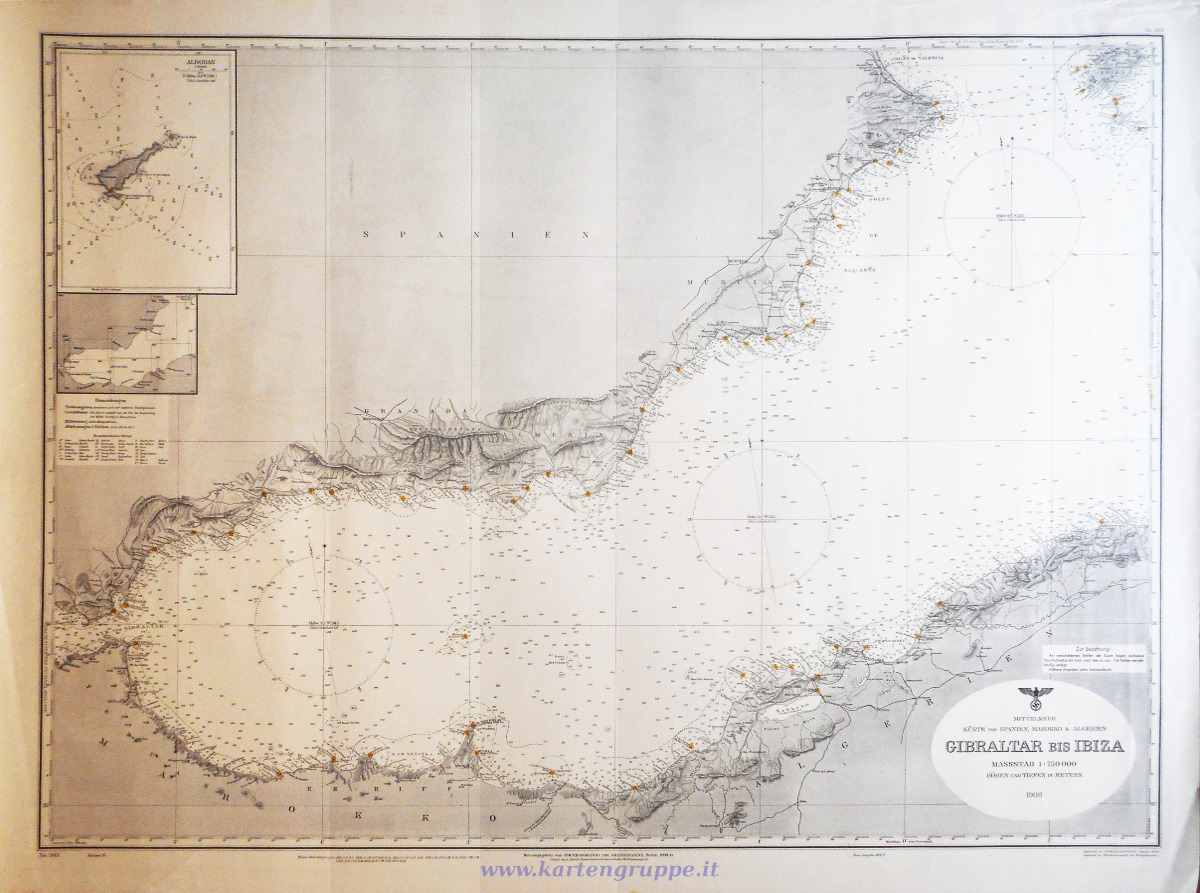 1:750.000, 1943 (su modello del 1908), Klasse III, 97,5 x 72 cm Note: Mappa con timbro tondo "Kriegsmarinewerft Wilhelmshaven Kartengruppe" e timbro lineare "KG43 47" sulla parte antiore e con timbro tondo "Kriegsmarinewerft Wilhelmshaven Kartengruppe" On the zip file there are the password Visit my collection on www.kartengruppe.it ... and if you like it click on G+1 (+ google search position) on the top right! Have fun Pino Quote:
|
|
|
|
|
|
03-26-12, 06:29 AM
|
#12 | |
|
Argentinian Skipper
Join Date: Jul 2009
Location: Somewhere between Buenos Aires and the Bungo Suido
Posts: 5,133
Downloads: 3219
Uploads: 0
|
Quote:
Next week I´m going to Chicago. IL, USA for my work (I will visit the U 505!); Returning, I ´ll ask you for some "doppione". Regards. Fitzcarraldo (Fernando De Cicco).
__________________
My subject is War, and the pity of War. The Poetry is in the pity - Wilfred Owen. |
|
|
|
|
|
03-27-12, 11:06 AM
|
#13 |
|
Loader
Join Date: Apr 2010
Location: Italy
Posts: 85
Downloads: 17
Uploads: 0
|
by www.kartengruppe.it
download link: D.Adm.63_Nordsee_SKAGERRAK_Kriegsmarine_Map_by_Kar tengruppe.it.zip 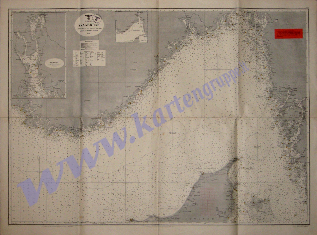 Nordsee - SKAGERRAK 1:300.000, 1944 (su modello del 1901), Klasse V, 122 x 90 cm Note: Mappa con timbro tondo "Kriegsmarinewerft Kiel Kartengruppe"sulla parte antiore e con retro prestampato con titolo e timbro tondo "Kriegsmarinewerft Kiel Kartengruppe" |
|
|
|
|
03-27-12, 02:21 PM
|
#14 | |
|
Argentinian Skipper
Join Date: Jul 2009
Location: Somewhere between Buenos Aires and the Bungo Suido
Posts: 5,133
Downloads: 3219
Uploads: 0
|
Quote:
Best regards! Fitzcarraldo
__________________
My subject is War, and the pity of War. The Poetry is in the pity - Wilfred Owen. |
|
|
|
|
|
03-27-12, 05:30 PM
|
#15 | |
|
Ace of the Deep
Join Date: Oct 2006
Posts: 1,151
Downloads: 152
Uploads: 0
|
Quote:
 Lost my beloved VIIC there after the longest and most tense night... one early summer morning in 1944...  Thanks for sharing your wonderful stuff! Jan. |
|
|
|
|
 |
|
|


 Linear Mode

