
|
|
SUBSIM: The Web's #1 resource for all submarine & naval simulations since 1997
|
SUBSIM: The Web's #1 resource for all submarine & naval simulations since 1997 |
 09-13-10, 07:09 PM
|
#1 | |
|
Admiral
 
Join Date: Apr 2005
Location: Dayton, Ohio
Posts: 2,292
Downloads: 474
Uploads: 64


|
[REL] 3000 Yard/Meter Bearing Plotter Tool
This is a rework of previous mods that dealt with an in-game bearing plotter for the Navigation and Attack Map screens. It is compatible for both American and German side of play, at either Metric or Imperial measurements (as long as you choose the correct edition), and at 8 "basic" game resolutions depending on your particular hardware and in-game settings.
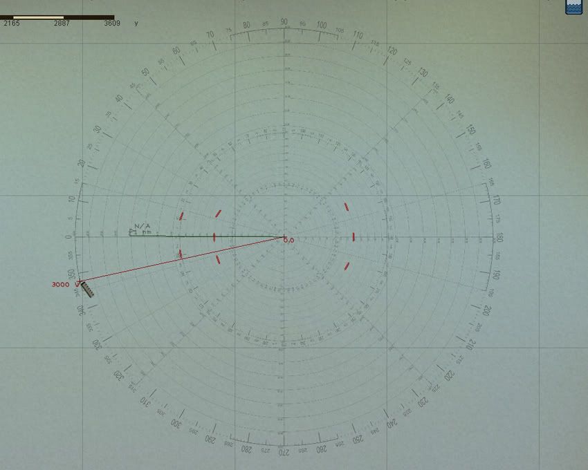 I take no credit for its design, or changes to the original made many years ago. My part was to rescale the device to accurately display for either Metric or Imperial measurements; to have it accurately scaled to the 8 "basic" screen resolutions, and to have these changes put into a thread that can be used by the submarine simulation community. The 8 "basic" resolutions are: 1024x 1152x 1280x 1360x 1440x 1600x 1680x 1920x When I state "basic", I'm referring to the basic family of Horizontal resolutions and "all" the Vertical resolutions used with it. Examples are the family of 1280x768, 1280x800, 1280x960, 1280x1024. The specific 1280x edition will work correctly with all the various Vertical resolutions of the 1280x family. In order to have a 3000 Yard/Meter Bearing Plotter the image has to be large to cover the native distance of the maps. This has made it necessary to create different editions for each resolution, and for each chosen unit of game measurement (Metric or Imperial). They are all JSGME compatible and are linked at the following: U.S. Customary Measurement (Imperial) 3000 Yard Bearing Plotter (1024x) 3000 Yard Bearing Plotter (1152x) 3000 Yard Bearing Plotter (1280x) 3000 Yard Bearing Plotter (1360x) 3000 Yard Bearing Plotter (1440x) 3000 Yard Bearing Plotter (1600x) 3000 Yard Bearing Plotter (1680x) 3000 Yard Bearing Plotter (1920x) Metric Measurement 3000 Meter Bearing Plotter (1024x) 3000 Meter Bearing Plotter (1152x) 3000 Meter Bearing Plotter (1280x) 3000 Meter Bearing Plotter (1360x) 3000 Meter Bearing Plotter (1440x) 3000 Meter Bearing Plotter (1600x) 3000 Meter Bearing Plotter (1680x) 3000 Meter Bearing Plotter (1920x) To install after downloading: The files are compressed using WinRaR. Use WinRAR or a compatible application to "Extract" the "3000 Yard (Meter) Bearing Plotter" to the "MODS" folder of JSGME (in the root directory of Silent Hunter 4, Wolves of the Pacific folder). Activate the mod through the JSGME instructions. I recommend activation of the Bearing Plotter AFTER any other mods you have activated in JSGME. This will correctly have the mod run as intended. It's note worthy that when or if you change the in-game graphic resolution, you must restart the game for the new resolutions to take effect. While at the Windows screen, this will be when you also activate in JSGME the correct edition for the resolution you've selected. One of the problems of the past 1500 yard plotters is that at 1500 yards the target is very nearly ready to be fired upon, giving little time to use the plotter as intended (to help plan the attack). At 3000 yards/meters, more time is given due to the extended size of the tool. Also something you will notice on the navigation screen is when the sub travels along its waypoint path the plotter will show 1 degree off center from the path of travel. This is not a problem with the plotter being incorrectly drawn. The plotter will come up 1 degree short to the right of center if you're heading turns right, or 1 degree short to the left of center if you're heading turns left. If anything this shows the plotter is dead on center. The problem is within the game code that for some reason comes up 1 degree short depending on which way you turn. We can't fix what the developers don't wish us to get our hands on!! Besides the rescaling of the plotter for the various uses, I changed the Maps.cfg to include an additional zoom level and tweaked the Attack Map starting zoom level. ============= Credit for the initial Bearing Plotter goes to Pato back in the SHIII days. CaptainCox, 13th4l, NoWonderDog, and Rockin Robbins have all had contributing work and revisions to the mod. Without their efforts I could not have completed my small part. ============= The following are in-game images. The first was taken with the game in a 1600x1200 resolution. I should point out the ruler is defined in 50 units of measurement either yards or meters. When dragging the ruler from a starting point the unit of measurement is accurate at the first point of its appearance. In other words 1500 yards is found at the point where 1450 yards first changes to 1500. 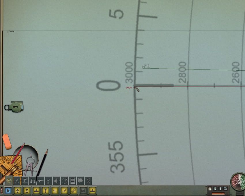 The next image was taken at a 1360x1024 resolution. 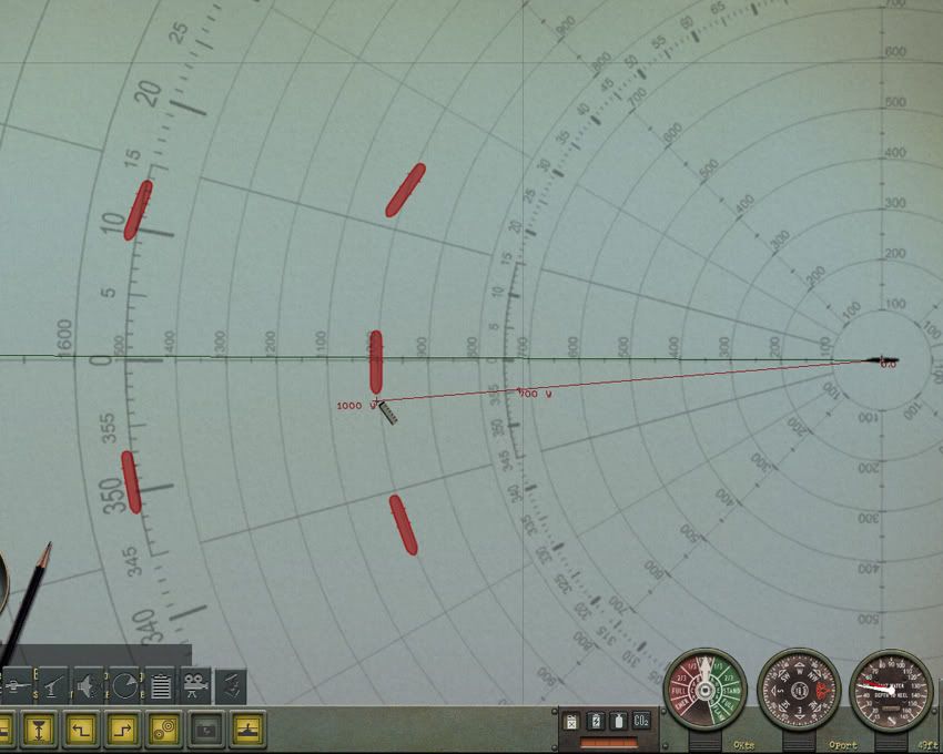 This is a computer found range of a target listed in the Position Keeper. The Kongo is at 1325 yards. 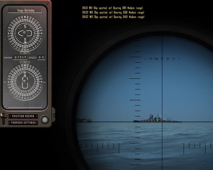 And the same target as it showed on the navigation map at a 1600x1200 resolution. 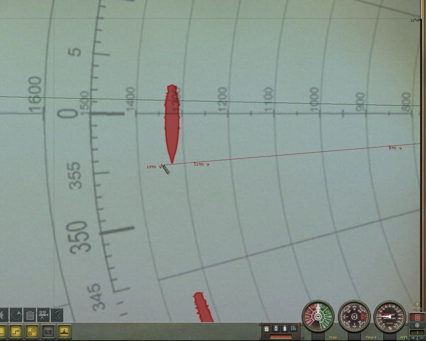 I'm sorry for the large download size. I tried all the tricks I knew but I couldn't get the image size further reduced. Luckily, only one image is used at a time since only one submarine is used at a time. The map screens have limited moving action so the size should not reduce frame rates too much.
__________________
 The HMS Shannon vs. USS Chesapeake outside Boston Harbor June 1, 1813 USS Chesapeake Captain James Lawrence lay mortally wounded... Quote:
Last edited by CapnScurvy; 09-15-10 at 07:16 AM. |
|

|

|
|
09-13-10, 07:39 PM
|
#2 |
|
Mate
 Join Date: Jun 2005
Location: Unknown ... until it's too late!
Posts: 60
Downloads: 149
Uploads: 0
|
Great work on this tool
 I hope this doesn't sound picky, but I was just wondering if there was any way to rotate the plotter tool as it seems to be off one's course by a degree plus at 3000 yards. Enjoy all of your work. I hope this doesn't sound picky, but I was just wondering if there was any way to rotate the plotter tool as it seems to be off one's course by a degree plus at 3000 yards. Enjoy all of your work.
__________________
I am. Therefore, I sink. |
|
|
|
|
09-13-10, 10:42 PM
|
#3 | ||
|
Admiral
Join Date: Apr 2005
Location: Dayton, Ohio
Posts: 2,292
Downloads: 474
Uploads: 64
|
Quote:
I've checked each and every edition, and in my opinion, the 3000 yard or meter versions are accurate. If I'm wrong I'll need to correct my mistake. So I've got to ask you, what edition are you using? With what unit of measurement? At what resolution is the game running in? Just a couple of notes, make sure you know what resolution your game is running in, not what resolution your Windows desktop setup uses. They can easily be different. Use the correct Bearing Plotter edition for what the game resolution is set AND the correct unit of measurement you're using in-game. Second, when you're using the ruler tool to measure distances, the units are broken down into increments of 50 (50 yards/50 meters). The point where the unit of measurement changes to the next division, marks that particular distance. For example, the ruler shows 750 meters, as you drag it further from the start point it will change to 800. This specific point of change is the 800 meter distance. The ruler will continue to read 800 meters until you reach the next 50 unit mark at 850. Further, a ship is positioned at the center of its distance or range, not at the leading edge of it. Using the Kongo again, its positioned exactly centered on the 1325 yard distance, even though the ships side (closest to the sub) is very near the 1300 yard line. The game figures measurements not on side distances or range to the edge of the target but on the center position of the object.
__________________
The HMS Shannon vs. USS Chesapeake outside Boston Harbor June 1, 1813 USS Chesapeake Captain James Lawrence lay mortally wounded... Quote:
Last edited by CapnScurvy; 09-13-10 at 11:04 PM. |
||
|
|
|
|
09-13-10, 11:14 PM
|
#4 |
|
XO
 Join Date: Sep 2002
Location: New York City
Posts: 408
Downloads: 439
Uploads: 0
|
Great stuff! Thanks Capn!

|
|
|
|
|
09-14-10, 08:49 AM
|
#5 | |
|
Mate
Join Date: Jun 2005
Location: Unknown ... until it's too late!
Posts: 60
Downloads: 149
Uploads: 0
|
Quote:
__________________
I am. Therefore, I sink. |
|
|
|
|
|
09-14-10, 10:35 AM
|
#6 | |
|
Admiral
Join Date: Apr 2005
Location: Dayton, Ohio
Posts: 2,292
Downloads: 474
Uploads: 64
|
Well, now that you bring it up I've doubled checked the Big Bearing Compass heading with the navigation map plotter and I do see a 1 degree discrepancy in what the periscope shows and what the plotter shows SOMETIMES?!? The plotter should be turned approximately 1 degree clockwise on a couple of the nearer ships. However, when I've gone out to the 3000 range areas the compass reading and the plotter bearings are exact!! Like I said, I didn't make the thing, I just scaled it to fit the various resolutions that are used. I'm sorry to have not checked it with a better tool.
Soooooooo, I'm going to fix the images and release the corrected version if I determine this is a big deal or not. If the 1 degree of difference doesn't make a difference to you then go ahead and use what's up on the download. I'll need to make 208 file changes; 13 stock subs x's 16 different mods. I just assumed the darn plotter was corrected for this long time known error of 1 degree off center!!!!! Guess not the version I used. And you know what they say about assuming!! I'm interested about the error in distance you described though. Where is the error there? If I'm going to rework the plotter and remake the mods I'd like to do it only one more time.
__________________
The HMS Shannon vs. USS Chesapeake outside Boston Harbor June 1, 1813 USS Chesapeake Captain James Lawrence lay mortally wounded... Quote:
Last edited by CapnScurvy; 09-14-10 at 05:25 PM. |
|
|
|
|
|
09-14-10, 01:03 PM
|
#7 |
|
Mate
Join Date: Jun 2005
Location: Unknown ... until it's too late!
Posts: 60
Downloads: 149
Uploads: 0
|
Capn, your distance is right on. I just mentioned 3000 yards as it was that compass circle on the plotter tool that indicated that 0 degrees on the plotter tool was different from one's plotted course.
__________________
I am. Therefore, I sink. |
|
|
|
|
09-14-10, 03:06 PM
|
#8 | ||
|
Admiral
Join Date: Apr 2005
Location: Dayton, Ohio
Posts: 2,292
Downloads: 474
Uploads: 64
|
Hydra, I've been further checking and I'm at a quandary as to what to do about this 1 degree discrepancy. The follow images are from a game using 1600x1200 resolution.
The first image is at the periscope station with a ship at 1004 yards distance. The bow is centered on a compass reading of almost 356 degrees. 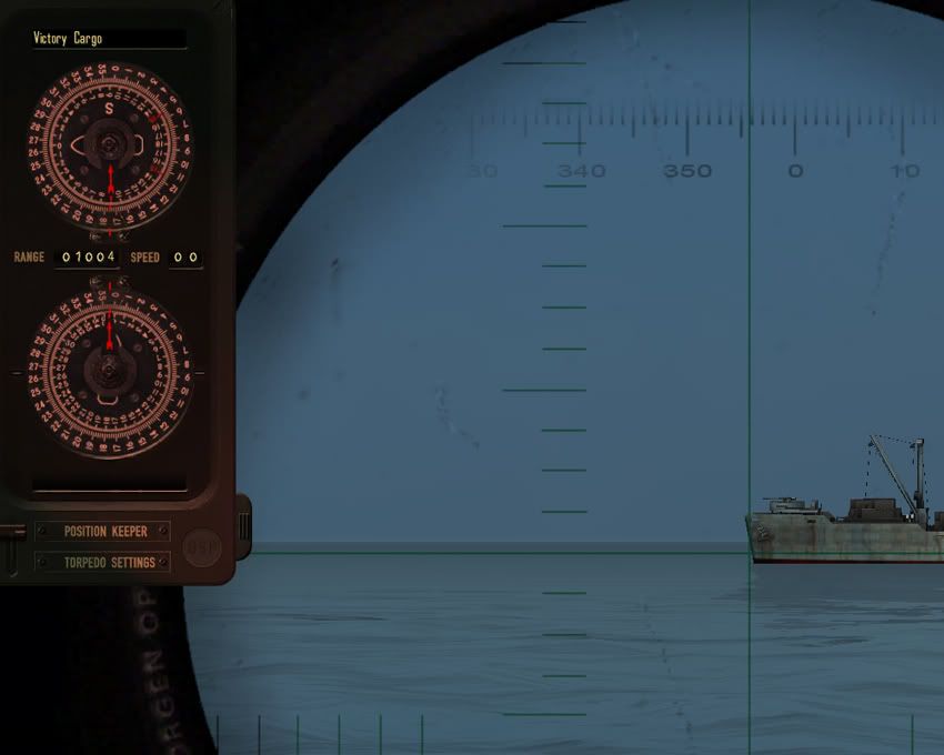 So we go to the navigation map and the same ship is at the correct range but the compass reading is at 357 degrees. Ah Haa! Here's the discrepancy we've been talking about. 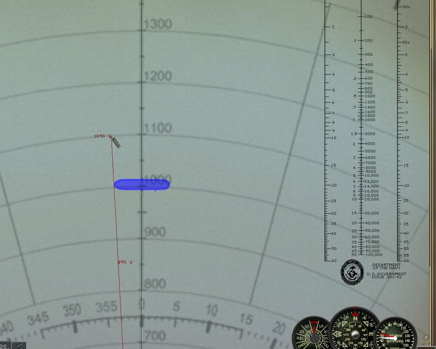 So I go to check another ship sitting out at the 3000 yard range and find it's bow at almost the 342 degree mark. 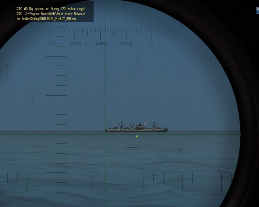 But wait, the bow reading is just half a degree off from what the periscope compass read!?! You would think the reading should read at least the same difference as the 1000 range ship. 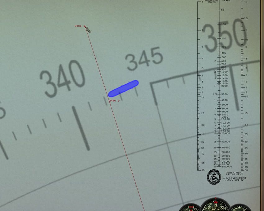 And here's a third target sitting at 1500 yards, with a bow compass reading of 18 1/2. 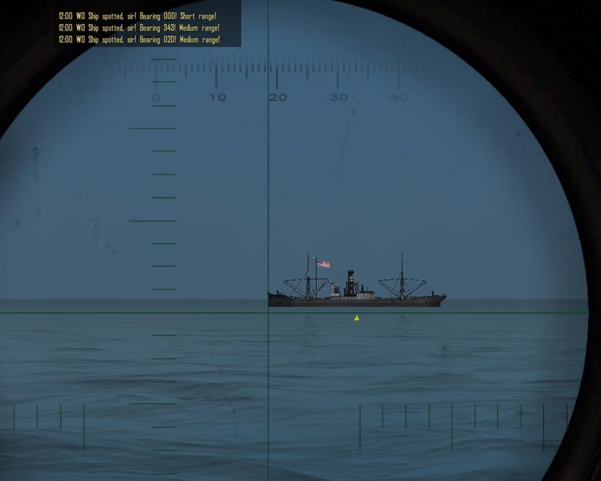 The same ship on the plotter reads exactly 18 degrees. 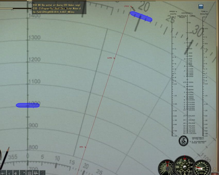 So here's the rub, if I move the plotter the 1 degree clockwise to correct the first ships discrepancy, the ship at the 1500 yard position will end up with it's bow at the 17 degree mark. So we correct one and make worse another. Actually the 3000 yard ship would be a wash, it is only a half degree off when compared to the periscope compass. Moving the plotter clockwise by one degree will have it then at a half degree difference on the other side of 342. I've checked this with a couple of other resolutions and have found the same differences. So unless I see a positive reason to change things, I'm just as well to let the sleeping dog lie. Compared to what the dev's gave us when the game first came out (the measuring units were in Nautical Miles for crap sake!!!!) one degree difference is dead on target to me. Quote:
__________________
The HMS Shannon vs. USS Chesapeake outside Boston Harbor June 1, 1813 USS Chesapeake Captain James Lawrence lay mortally wounded... Quote:
Last edited by CapnScurvy; 09-14-10 at 03:50 PM. |
||
|
|
|
|
09-14-10, 04:57 PM
|
#9 |
|
Loader
 Join Date: Apr 2005
Location: Texas
Posts: 86
Downloads: 23
Uploads: 0
|
A BIG THANK YOU
|
|
|
|
|
09-17-10, 03:08 PM
|
#10 |
|
Navy Seal
 Join Date: Mar 2007
Location: DeLand, FL
Posts: 8,899
Downloads: 135
Uploads: 52

|
Capn, my original automatically changed units from imperial to metric when you switched boats from sub to U. I like to use native tools for both. It's easy to do. You want to do it or should I?
Great job there. Downloaded!!!! 
__________________
Sub Skipper's Bag of Tricks, Slightly Subnuclear Mk 14 & Cutie, Slightly Subnuclear Deck Gun, EZPlot 2.0, TMOPlot, TMOKeys, SH4CMS |
|
|
|
|
09-23-10, 11:52 AM
|
#11 | |
|
Admiral
Join Date: Apr 2005
Location: Dayton, Ohio
Posts: 2,292
Downloads: 474
Uploads: 64
|
Double R,
since I'm unaware of how to have one image that reflects both Metric and Imperial corrected distances when the "Authentic" option is set for the type of unit measurements used; lead on!! Does it have something to do with scaling the image to a size that sits in the median between the two different image sizes? If one image can work correctly for both units of measurements I can see this as an advantage. ==================== EDIT: I've looked at the "3000 Yard-Meter Bearing Tools (1280x960)" that you've referred to in your down loadable mods section. It's accurate if you use the "Authentic" units of measurements enabled in the game options (least it's accurate enough; it is off a bit when you measure to a line, the lines are greater in distance when compared to the ruler measurement) but, if you enable either the Metric or Imperial units of measurements neither one comes close to accurate. So, if you use the "Authentic" option you can be fairly close to what you need. Using the other two, you'll find you're off by 80 to 100 meters/yards depending on which unit of measurement you choose. To be fair, the incorrect usage of one of my scaled editions will result in just as inaccurate a finding. If you set the "Authentic" option and use the "3000 Meter Bearing Tool (1280x)" for the American side of play you'll be no closer to an accurate reading than the result of your version. You would if you play the German side, but not the American. So, what's important is to use the correct edition for the correct game resolution you use AND, pair it up with the correct unit of measurements you use too. Just remember if you play with the "Authentic" option, don't expect one of my 3000 Yard bearing versions to work when you play the German side, use a Meter version instead. (and don't expect the "3000 Yard-Meter Tools (1280x960)" mod to be accurate if you have anything other than the "Authentic" option enabled). I hope this doesn't get any more complicated than this!! 
__________________
The HMS Shannon vs. USS Chesapeake outside Boston Harbor June 1, 1813 USS Chesapeake Captain James Lawrence lay mortally wounded... Quote:
Last edited by CapnScurvy; 09-23-10 at 02:20 PM. |
|
|
|
|
|
09-27-10, 11:13 AM
|
#12 |
|
Pacific Thunder

 Join Date: Apr 2004
Location: Yellow Sea
Posts: 1,896
Downloads: 236
Uploads: 14
|
I've installed and like this CapnScurvy. Thanks.
I don't know which one I was using before but it was accurate when measured from the torpedo tubes whether fore or aft and at any resolution. It was 1,500 yards and about 5 MB. I used the compass to get accurate measurements in yards so if I remained undetected I could plot where the target would need to be when I was to shoot. I extended the plotting lines with the ruler tool. I don't know how the 1,500 yard plotter I used before automatically re-sized to different screen resolutions and was accurate from the tubes, not the periscope. Maybe it was RR's? Happy Hunting! Art PS: I've never played the U-Boat side so I can't say about that.
__________________
" Bless those who serve beneath the deep, Through lonely hours their vigil keep. May peace their mission ever be, Protect each one we ask of thee. Bless those at home who wait and pray, For their return by night and day." Last edited by aanker; 09-27-10 at 11:28 AM. |
|
|
|
|
03-09-11, 09:25 PM
|
#13 |
|
Nub
 Join Date: Mar 2011
Posts: 2
Downloads: 18
Uploads: 0
|
Hi, my apologies for bringing up an older post, however i am just now getting back into SH and would really like to use this plotter.
I am guessing that the fact that i am running at a native resolution of 2560x1440 on my DELL U2711monitor along with the SH4 1.5 add-on means the plotter wont work for me? If so, I am not sure off hand what size textures my ATI Radeon HD 5870 can handle, however i imagine pretty decent size. Does anyone know the best way to upscale one of the lower res versions for use at my resolution and be able to keep it accurate? Last edited by Onkel Neal; 04-01-14 at 08:10 AM. |
|
|
|
|
03-12-11, 07:55 AM
|
#14 | ||
|
Admiral
Join Date: Apr 2005
Location: Dayton, Ohio
Posts: 2,292
Downloads: 474
Uploads: 64
|
Quote:
By trying to make an image for that size of screen resolution I'd guess the thing would be 40; 50MB; maybe more in size. Your computer may be able to handle the extra burden, but realize the original stock image was only a few KB in size. The game (released in early 2007) was never intended to handle the kinds of resolutions we can throw at it today. Your computer may handle the increase in hardware usage (at first) but, lets put a large convoy of ships in motion along with this memory hog of an image and I'm thinking the game will be ready to throw in the towel. Just a guess, I can be wrong. If you want to try and make an image though, use an application like PhotoShop with the nVidia plug-in found HERE (you will use the plug-in to make the .dds formated image when your done resizing it). Step 1: Take a copy of the original image and re size (to what???? I don't know, this is trial and error), save the image, and load it into the game. Check the distance out to the 3000 yard distance with the ruler and see what you get. If it doesn't read 3000 go back to Step 1 again. Have fun.
__________________
The HMS Shannon vs. USS Chesapeake outside Boston Harbor June 1, 1813 USS Chesapeake Captain James Lawrence lay mortally wounded... Quote:
|
||
|
|
|
|
03-12-11, 09:16 AM
|
#15 |
|
Watch Officer
 Join Date: Mar 2010
Location: Yuba/Sutter, CA
Posts: 347
Downloads: 171
Uploads: 0
|
I am using the 1680x1050 version and it seems to be out of scale. I used the ruler and it measures 3250 yards at the 3000 yard line and similar proportional errors at 750 and 1500 yards. I have comfirmed my game to be running 1680x1050.
__________________

|
|
|
|
 |
|
|


 Linear Mode

