
|
|
SUBSIM: The Web's #1 resource for all submarine & naval simulations since 1997
|
SUBSIM: The Web's #1 resource for all submarine & naval simulations since 1997 |
 12-27-10, 12:49 PM
|
#31 | |
|
Weps
 Join Date: Apr 2007
Posts: 351
Downloads: 35
Uploads: 0
|
Quote:
__________________
|
|

|

|
|
12-27-10, 06:02 PM
|
#32 | |
|
Sea Lord
 Join Date: Jun 2006
Location: Somewhere else now
Posts: 1,660
Downloads: 801
Uploads: 4
|
Quote:
I'd like to see pics of the mod and ideas though... maybe I can provide some input. |
|
|
|
|
|
12-28-10, 06:30 AM
|
#33 |
|
Silent Hunter
  Join Date: Dec 2004
Location: AN9771
Posts: 4,892
Downloads: 300
Uploads: 0
|
Check the messages of the user don1reed in this thread:
http://www.subsim.com/radioroom/show...47#post1558947 Specifically post 154 and the 2 following. He has much personal experience in celestial navigation, and applied it often in the game (in as much as SH3 and SH4 allowed).
__________________
My site downloads: https://ricojansen.nl/downloads |
|
|
|
|
01-05-11, 11:37 PM
|
#34 |
|
中国水兵
 Join Date: Dec 2010
Posts: 278
Downloads: 91
Uploads: 0
|
First real Navigation with help of dead recon, sunset- and celestial-navigation.
xxxxxxxxxxxxxxxxxxxxxxxxxxxxxxxxxxxxxxxxxxxxxxxxxx xxxxxxxxxxxxxxxxxxxxxx (1) 4 1/2 min after Sunset near Bornholm (in the right side of the photo) at real position 55.00,00N 15.00,00E  I read a sunset (upper-limb of the sun fully disappears behind the horizon) at 18:15:50 GMT. But at my actual position of 55.00,00N 15.00,00E the sunset had to be at 17:53:00 GMT according to this 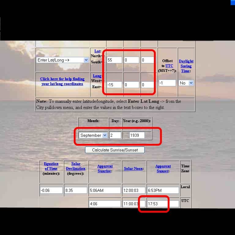 http://www.srrb.noaa.gov/highlights/...e/sunrise.html Sunsetcalculation for a specific time and location. So this gives me an error of 5°40' because the sunset at 18:15 GMT for Sep 02 1939 is at location 009°20E, 15°00N which gives me an error of 361.3 km ( http://www.movable-type.co.uk/scripts/latlong.html ). (2) Actual Moon at 02-Sep-1939, 21:00 local time 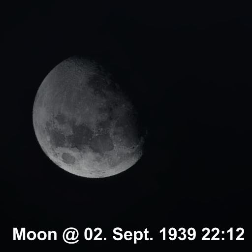 The moon-display could be correct because the correct phase of the moon (according to http://www.maa.mhn.de/StarDate/moon1939.txt ) is Full moon 29-Aug-1939, 22.16 Last quarter 06-Sep-1939, 20.41. (3) Celestial navigation with Polaris (north star). Polaris + sextant gives me a position of 53°09N. 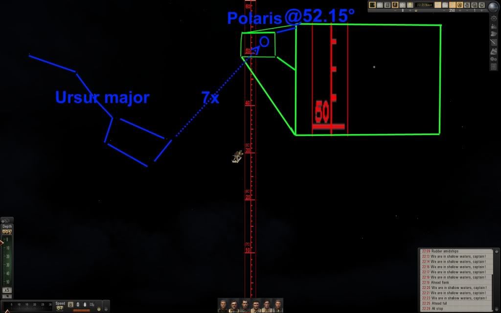 The reading was 52.15 + 1 (correct the misleading of polaris) = 53.15 = 53°09'. But i am at position 55°00N. So the Polaris gives me an error of 1°51' = 205.7 km. ( http://www.movable-type.co.uk/scripts/latlong.html ) (4) My Route with dead reckon-navigation in real time: 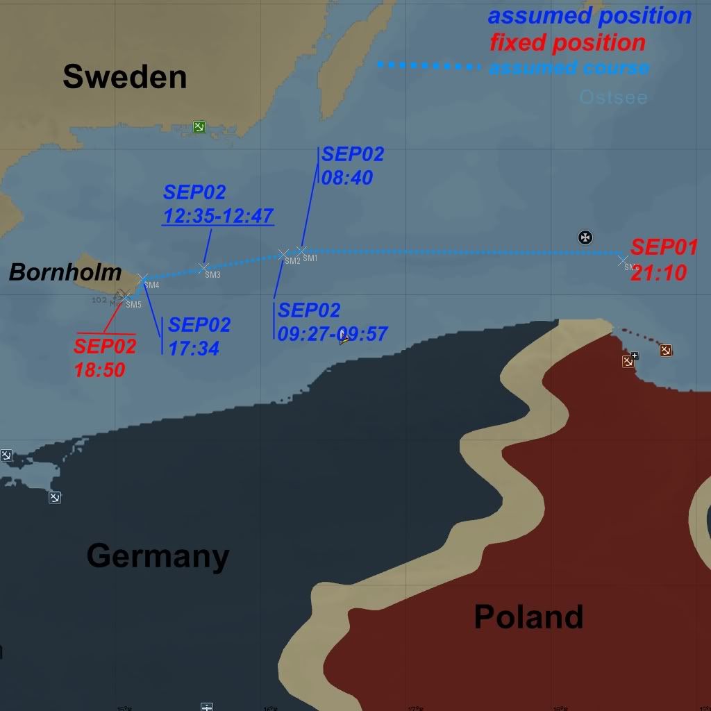 The fact that i reached Bornholm (that was my intention) surprised me and was not so bad. |
|
|
|
|
01-05-11, 11:58 PM
|
#35 |
|
Black Magic
 Join Date: Jun 2007
Posts: 11,962
Downloads: 147
Uploads: 5
|
pretty cool! The integrated mod of Otto's chalkboard in my UIs mod has a sunrise/sunset/moonphase calculator built into it. You access it by pressing shift+B

|
|
|
|
|
01-06-11, 12:15 AM
|
#36 |
|
中国水兵
Join Date: Dec 2010
Posts: 278
Downloads: 91
Uploads: 0
|
Didn't know that. Thxs.
|
|
|
|
|
01-07-11, 09:59 AM
|
#37 |
|
Sea Lord
Join Date: Jun 2006
Location: Somewhere else now
Posts: 1,660
Downloads: 801
Uploads: 4
|
Ah.. thanks for the pics...I see not much has changed since SH3 days
|
|
|
|
|
04-11-11, 02:42 PM
|
#38 |
|
Weps
Join Date: Jan 2007
Posts: 356
Downloads: 36
Uploads: 0
|
This is interesting stuff.
Does the in-game sextant work like they do in real life? In other words, can I use the real-world navigation links provided earlier in this thread and just use the tools in game to get a fix, or do I have to apply some other techniques to compensate for any in-game limitations on the SH5 sextant, sky, celestial bodies, etc? |
|
|
|
|
04-12-11, 03:47 PM
|
#39 | |
|
中国水兵
Join Date: Dec 2010
Posts: 278
Downloads: 91
Uploads: 0
|
Quote:
(1) vertical sextant angle for coastal navigation: here distance-measurement 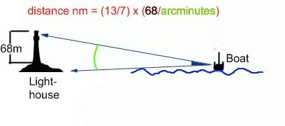 Code:
================== | arc | distance | in ° | in m | ================= | 0.2 | 19385.948 | 0.225 | 17231.935 | 0.25 | 15508.723 | 0.275 | 14098.82 | 0.3 | 12923.9 | 0.325 | 11929.735 | 0.35 | 11077.592 | 0.375 | 10339.067 | 0.4 | 09692.856 | 0.425 | 09122.669 | 0.45 | 08615.835 | 0.475 | 08162.351 | 0.5 | 07754.214 | 0.55 | 07049.248 | 0.6 | 06461.773 | 0.65 | 05964.675 | 0.7 | 05538.589 | 0.75 | 05169.312 | 0.8 | 04846.192 | 0.85 | 04561.083 | 0.9 | 04307.652 | 0.95 | 04080.895 | 1.0 | 03876.8 | 1.1 | 03524.299 | 1.2 | 03230.532 | 1.3 | 02981.954 | 1.4 | 02768.881 | 1.5 | 02584.213 | 1.6 | 02422.623 | 1.7 | 02280.04 | 1.8 | 02153.294 | 1.9 | 02039.886 | 2 | 01937.815 | 2.5 | 01549.898 | 3 | 01291.221 | 3.5 | 01106.395 | 4 | 00967.726 | 4.5 | 00859.829 | 5 | 00773.472 | 6 | 00643.837 | 7 | 00551.128 | 8 | 00481.497 | 9 | 00427.252 angle between 2 points (lighthouse, factory)  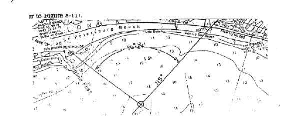 (3) Vertical sextant angle for moon/star/sun-shoot. 1 and 2 working pretty much out of the box. For 3 it depends on your screen-resolution. A rework of the sextant correspond to your screen resolution is probably necessary. For good accuracy many uses the program stellarium. Also what you need here is definitely a nautical almanac of 1939 resp. 1940 or later or a program that creates nautical almanac data. |
|
|
|
|
|
04-20-11, 02:32 PM
|
#40 |
|
XO
 Join Date: May 2008
Location: oslo,Norway
Posts: 424
Downloads: 254
Uploads: 0
|
can anyone tell wich mods I need from DKW s ui mod for real navigation (in addition to real navigation)? I have a pretty good idea but he just said no mapupdates etc etc...do I put them behind the megamod?can I put in hole of dkw s ui mod maybe just to be sure ? I get confused what is the actual mod and what are add on mods but I ll have a closer look at the files there.
|
|
|
|
|
04-20-11, 02:35 PM
|
#41 | |
|
Ocean Warrior
 Join Date: Dec 2010
Location: Montreal, Canada
Posts: 2,776
Downloads: 833
Uploads: 11
|
Quote:
NewUIs_TDC_6_4_0_ByTheDarkWraith NewUIs_TDC_6_4_0_Real_Navigation |
|
|
|
|
|
04-20-11, 05:41 PM
|
#42 |
|
XO
Join Date: May 2008
Location: oslo,Norway
Posts: 424
Downloads: 254
Uploads: 0
|
thx for quick answer. I was in a bit of a hurry when I wrote the post. I have put in the beta megamod and I think new ui s is a part of that but not the add mods, and I put the add ons I need after the megamod right?
|
|
|
|
|
04-20-11, 05:41 PM
|
#43 | |
|
Black Magic
Join Date: Jun 2007
Posts: 11,962
Downloads: 147
Uploads: 5
|
Quote:
|
|
|
|
|
|
04-20-11, 05:45 PM
|
#44 |
|
XO
Join Date: May 2008
Location: oslo,Norway
Posts: 424
Downloads: 254
Uploads: 0
|
thx again

|
|
|
|
|
04-21-11, 09:46 AM
|
#45 |
|
Helmsman
 Join Date: Feb 2010
Posts: 106
Downloads: 15
Uploads: 0
|
Pardon my ignorance, but I haven't been keeping up with the community in between my bouts of playing SHV (I play it on and off, with bursts of enthousiasm *grin*).
But just what are the features of Real Navigation? I can't find the mods workshop thread for it, and what I did find remains a bit obscure. I understand it no longer shows the boat's position on the map, but what features are added to enable navigation? Also, is it part of the UI mod now? I've got an early version of TDW's mod, and now am daunted by the idea of ripping it out and trying to wedge in an updated version with my other mods. It's gotten to the point I should probably uninstall/reinstall, but I'd rather avoid that. Mind you, I love the UI and AI mod. Itkovian |
|
|
|
 |
|
|


 Linear Mode

