
|
|
SUBSIM: The Web's #1 resource for all submarine & naval simulations since 1997
|
SUBSIM: The Web's #1 resource for all submarine & naval simulations since 1997 |
|
|
 12-11-19, 12:54 PM
|
#1 |
|
Navy Seal
 
Join Date: Dec 2012
Location: France
Posts: 6,111
Downloads: 467
Uploads: 0


|
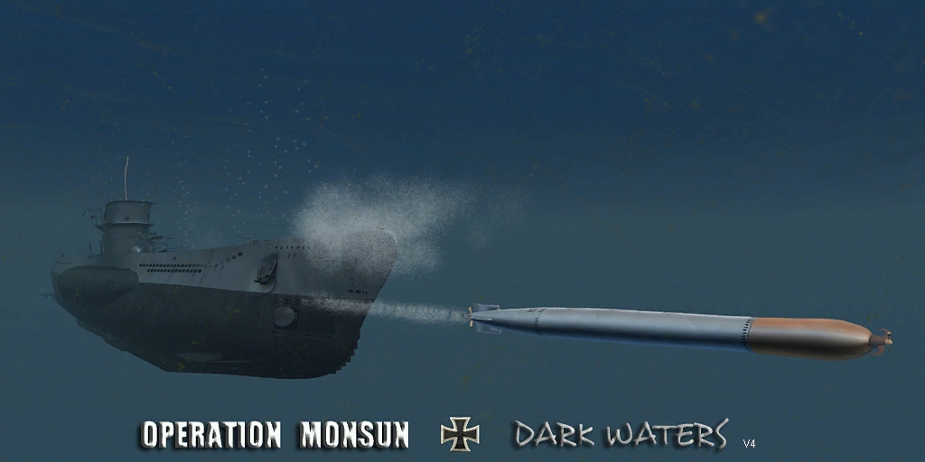 Dark Waters is a completely new version of my Fifi Compilation for OM+OMEGU. Dark Waters is based on Operation Monsun (thanks again to Lurker) but without OMEGU to avoid those random CTDs we had. Dark Waters has new environment based on OMEGU but quite different. Many things has been re-worked, the list is too long to be here. WARNING: Dark Waters is designed for 1920X1080 resolution!... and the use of METRIC in the realism settings (not tested on authentic/imperial) You will need a fresh clean V1.5 install, with fresh clean Document/SH4. Only 1 mod to activate! Original OM is included in Dark Waters. Once Dark Waters activated, you will find in your Jsgme 10 optional add-on mods. They have to be activated after Dark Waters in whatever order only if you need it: - OM Harder Escort L1 and L2, only one activated at a time AT CAREER START, to get harder escorts. - OM Med and Pac Env, only one activated at a time in bunker, if playing in Mediterranean or Pacific theater. - OM_SubFlag_When_Snorkel has to be activated to keep a static flag when snorkel equipped. - OM U-Jagd if you want the U-Jagd chrono to find target speed instead of AOBF. Can be activated in bunker but best at career start. - OM Warm Clothes if you want your crew with warm clothes for Atlantic theater. Can be activated/deactivated in bunker. - OM Strategic Map Symbols will bring more accurate map symbols for mission objectives. Can be activated anytime in bunker. - OM_UMark will restaure the external orange mark above your U-Boat while submerged. - WIP U-Flak Career if you want to try suicidal missions...Activate it only to play U-Flak career at career start. Deactivate it to play regular career. This is what you should get once Dark Water activated: 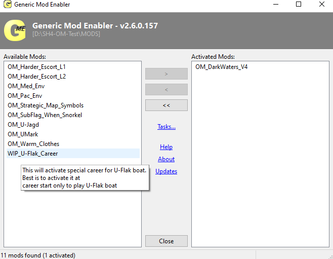 Don't forget to install Large Adress Aware as usual, and set your SH4.exe for NO read only...Dark Waters need some extra RAM! Best play is no more than X1024 time compression! Best is to adjust your settings in Documents/SH4/Data/Cfg/main as: TimeStop=0 RealTime=1 LandProximity=128 CriticalDamage=1 CrewEfficiency=128;1 AirEnemyDetected=1 SoundEffects=512 CharacterAnim=8 EnemyDetected=1 RadioReport=1 Particles=64 PrayState=256 HunterState=256 3DRender=1024 Maximum=1024 To access easily the AA crew slots in crew management page, just hit NumPad + Delete to hide HUD !! Many thanks to the modders of FOTRSU, of KSD, of WAC5 as Dark Waters has imported elements from there. Special thanks to Alx Novoros for his permission to dig into KSD. ----->DOWNLOAD V6: http://www.mediafire.com/file/4qci5x...ers_V6.7z/file IF YOU HAVE THE TURM UPGRADE ISSUE (from SKIDMAN): « Both the Typ VII and the Typ IX U-Boat will receive conning tower upgrades as the game proceeds. Every time I was awarded a new "Turm", the result was a submarine that could not move forward, or backward. A "Cannot comply" message was displayed instead. The crew screen showed missing and empty slots. This bug has been experienced and described before, and -as lurker put it- it is a nasty one. So from my experience a conning tower upgrade means end of your career. This is not acceptable. How can you continue? Well, there is a workaround: You have to create a dummy file. 1.) Open your saved games folder (SH4/data/cfg/SavedGames), locate the folder that contains the autosave_on_leaving_base-file using the file creation date and time and make a backup copy. 2.) Fire up SH4 and start a new career. Choose date, type of boat and flotilla to match the state of your career as close as possible. Start a new mission. Save the game. 3.) From the new folder (the one you just created in the saved games folder when you saved the dummy game ) you will need the ActiveUserPlayerUnits-file. Copy it to the desktop and open the copied file using a text editor (i.e. wordpad) 4.) Open the ActiveUserPlayerUnits-file from the autosave_on_leaving_base-folder (Step 1) with your text editor 5.) In the AUPU-File from the dummy locate: [UserPlayerUnit 1.Compartment 1. CrewMemberSlot 1] copy this line and the following lines till [UserPlayerUnit 1.UnitPartSlot 1.UnitPart . UpgradePackSlot 1] near the end of the document. 6.) Replace the lines (Step5) with the content of the clipboard in the AUPU-File from the autosave_on_leaving_base-folder. Save the file. 7.) Copy the manipulated file to the UPCINitial Folder of the autosave_on_leaving_base-folder. 8.) Fire up SH4, choose "Load Game", open the autosave_on_leaving_base-File and play on. Your rank, medals, tons sunk and crew will be preserved and your boat will have the new conning tower. Sounds complicated, but OM forces you to go through this again and again and practice makes perfect » ABOUT SMA MINES FOR USE IN VIID: 12.SMA Mine deployment. Since it is not possible for me to recreate the launching of the SMA Mines from the mine tubes in the center of the Type VIID, you will be launching them trough the aft torpedo tubes. The .sim file for the Type VIID as been modified to support 15 SMA mines and to launch and reload them ever 15 seconds. You will find that you have one already loaded in the aft tube plus 10 in ready reserve, with the remaining 4 in the external storage. To launch do the following: A. set ships speed to 4 knots B. go to Attack Map C. select tube 5 D. select manual TDC input E.set bearing to 180 F. set desired mine depth G. launch mine with fire button H. next mine will be ready to launch in about 15 seconds There is a more detailed set of instructions in the X:\Program Files\Ubisoft\Silent Hunter Wolves of the Pacific\Support\OM_Readme_files, look for SMA Mine Deployment.doc WARNING Do not load SMA mines in Uboats other than Type VIID Do not load SMA mines in the forward tubes of any Uboat Do not load torpedoes in the aft tubes of a Type VIID Once all mines out, in order to use again the chronometer (mines are figured by static torpedoes but their looking is real mines) you have to save/exit/reload and the chronometer will stop running without control, ready for further use. My best Nvidia settings for Dark Waters: https://www.subsim.com/radioroom/sho...&postcount=107 Nice video from Leviathan: Last edited by Fifi; 06-03-20 at 09:28 AM. |

|

|
|
12-11-19, 07:10 PM
|
#2 |
|
Torpedoman
 Join Date: May 2012
Location: Under the Sea
Posts: 119
Downloads: 238
Uploads: 0
|
This looks great! I can't wait to give it a try. Thank you for all of your hard work!

|
|
|
|
|
12-12-19, 02:39 AM
|
#3 |
|
Planesman
 Join Date: Apr 2011
Location: Trier, Germany
Posts: 187
Downloads: 431
Uploads: 0
|
loading now
|
|
|
|
|
12-12-19, 03:20 AM
|
#4 |
|
Navy Seal
Join Date: Dec 2012
Location: France
Posts: 6,111
Downloads: 467
Uploads: 0
|
Dont forget to create new Documents/SH4 folder once Dark Waters is activated.
Keep in mind DW is designed for 1920X1080 resolution (not tested on other resolution) and for the use of METRIC in realism settings (not tested on authentic/imperial) In graphic settings, best Is to deactivate Post process filters, Full scene glare, Light shafts, Volumetric fog wich gives pretty bad Rendering results... Last thing, in museum (quite long to load due to hundreds of units) you should avoid to load any submarine ... still some issues for them in museum  Good hunting! 
__________________
 |
|
|
|
|
12-12-19, 04:12 AM
|
#5 |
|
I break things

Join Date: Jan 2013
Location: Merry Old England
Posts: 782
Downloads: 1156
Uploads: 10

|
Do not select these 2 ships in the Museum or you will CTD
- NDD_Adroit - fixed - TO3A - fixed --------- Small repairs for surface ships: - NDD_Wicher - no texture - fixed - NBB_Rodney - AA Gun .sim - fixed - NOM_Paula - missing Wake - correction .sim to raise in water - fixed --------- 4 missing surface ships from Museum: - NAux_LC - fixed - NAux_SmallLC - fixed - NCLT - fixed - NLCT_GE - fixed --------- The Russian subs will explode and CTD if you do not move quick enough to next unit. SSTypeKXIV - WIP SSTypeMXII - WIP SSTypeShChX - WIP --------- The German Subs have features missing and will CTD as you scroll through them, I think it's the forth inline ?!? --------- I upload to Fifi & propbeanie once completed.
__________________

Last edited by s7rikeback; 12-12-19 at 05:52 AM. |
|
|
|
|
12-12-19, 04:16 AM
|
#6 |
|
Planesman
Join Date: Apr 2011
Location: Trier, Germany
Posts: 187
Downloads: 431
Uploads: 0
|
up and running....looks nice thus far
|
|
|
|
|
04-06-21, 04:24 PM
|
#7 | |
|
Silent Hunter
 
 Join Date: Sep 2007
Location: Gone to Texas. No More Kleptocratic Government for me!
Posts: 4,289
Downloads: 465
Uploads: 29

|
Quote:
i believe there is a list of ships in the mod documentation of which there is a great deal. check there. 
__________________
there are only two things in the world: submarines and targets. Fortis et stabilis et fidelis, semper   ------------------------------------------------------------ Silent Hunter 4 1.5 Gold Edition on CDROM LAA enabled Dell XPS with 32 GB Ram running Win10 |
|
|
|
|
|
04-06-21, 05:16 PM
|
#8 |
|
Seaman
 Join Date: Jun 2018
Location: Phoenix, AZ
Posts: 36
Downloads: 22
Uploads: 0
|
Well I got to the Mediterranean.... sailed all over...ran into a couple of British destroyers but there weren't a lot of merchant targets.
I guess all those convoys that spawn in the Atlantic near Gibraltar never sail through the Med to get there? Or maybe a big ship was stuck in Suez? Anyway, back to the Atlantic for me! |
|
|
|
|
01-28-20, 01:13 AM
|
#9 | |
|
Nub
 Join Date: Jan 2020
Location: Alabama
Posts: 2
Downloads: 343
Uploads: 0
|
Quote:
Always watchin your channel. Luvin it! keep up the content and the hard work! its awesome |
|
|
|
|
|
01-28-20, 06:46 AM
|
#10 |
|
Growing Old Disgracefully

Join Date: Dec 2012
Location: Hythe - Southampton
Posts: 9,609
Downloads: 1133
Uploads: 0

|
A Warm Welcome To The Subsim Community > jj0666
Subsim <> Make A Donation <> See The Benefits <> Support The Community SH3 4 - 5 Tutorials > Downloads > Other Useful Information > See Links in My Signature Below
__________________
LSH3-2015 <> TUTORIALS <> ALL YOU NEED TO KNOW <> ALL IN ONE PLACE SH4 <> TUTORIALS <> HOW TO DO IT <> INFORMATION <> DOWNLOAD LINKS SH5 <> TUTORIALS <> HOW TO DO IT <> INFORMATION <> DOWNLOAD LINKS Always Here To Help A Fellow 'Subber' | Need An Answer to A Question Just Send Me A PM |
|
|
|
|
01-28-20, 06:52 AM
|
#11 |
|
Watch
 Join Date: Mar 2019
Posts: 24
Downloads: 98
Uploads: 0
|
Could you please look into updating the torpedo textures and models?
I feel like with all the updated Uboat textures and models the torpedos have come quite of age. I've tried using torpedo HAHD form sh3 myself but a few torpedo textures bug out ingame, although they dont in s3d 
|
|
|
|
|
01-28-20, 07:16 AM
|
#12 | |
|
Navy Seal
Join Date: Dec 2012
Location: France
Posts: 6,111
Downloads: 467
Uploads: 0
|
Quote:
Its more complicated than it seem, you experienced it. Right now, real life is slowing my modding time, so...
__________________
|
|
|
|
|
|
06-21-20, 12:01 PM
|
#13 |
|
Torpedoman
Join Date: Jun 2013
Posts: 113
Downloads: 33
Uploads: 0
|
Hey, would love to play the mod, however a question remains, you said you build it on OM/OMEGU, does it include the Type II, Type XXIII and Type XXI uboats?
|
|
|
|
|
06-21-20, 12:25 PM
|
#14 | |
|
Swabbie
 Join Date: Oct 2013
Posts: 8
Downloads: 20
Uploads: 0
|
Quote:
They're all in the mod Quick question on my part: Are Flower class corvettes incredibly adept at finding u-boats or am I going crazy? It's only early 1940, yet the Flower escort of the convoy I'm trying to attack keeps detecting me when I'm running silent at a dead stop or less than one knot and several kilometers out. I can sit there at extreme depth and it'll leave me alone, but as soon as I start to approach periscope depth, even in the middle of the convoy, it knows I'm there once I pass ~30m depth. Then it calls in the three other destroyers and they all depth-charge me (which I am pretty good at evading if I know they're coming, but it also means that it is impossible to attack that convoy for me since I can't even get a minute or so in peace to identify if I'm shooting at neutrals and get a solution before I have to bugger out). Edit: Seas are calm and it's a clear night, which I know makes it easier for the escorts to detect me, but goddamn they're good. I didn't think they'd detect me so easily. It's odd, when I snuck into Scapa Flow my boat moved slightly faster, seas were calm and I was also merely at periscope depth yet they didn't detect me even when passing right overhead, while now they detect me at like 5km out. Is this one of those elite escorts? Last edited by HK_01; 06-21-20 at 12:35 PM. |
|
|
|
|
|
06-21-20, 07:54 PM
|
#15 | |
|
Admiral
 
Join Date: Sep 2016
Location: Grand Rapids, Mi.
Posts: 2,327
Downloads: 491
Uploads: 0
|
Quote:
But.. Be warned, there is NO functionality to being able to transfer from the boat you start off with, to another different boat mid-career... Following from the original Op. Monsun to the ever present Dark Waters, there is NO modeling in game, for that function... due to issues caused with having that full functionality from the base SH4.. that is open to U.S. subs. A work around to that, would be to go to a set point in your career, should you survive to that date point, then go back to main career, start off into a boat & then see of some means to set up the tonnage count & Renown you garnered in the previous career to the new career start off, making sure that you use the same name as before for continuities sake... that may be doable.. another could cross verify this idea, would be greatly appreciated... maybe, just maybe some one could create a mod to simplify that process, if it is indeed, doable.. I would, but would NOT have any idea where to even begin.. and am working on a mod idea of My own but with radio for another mega.. that is in sore need of promoters for it & that project of Mine, is kinda got Me short of pulling what little hair I got left out by the roots...  
__________________

|
|
|
|
|
 |
|
|


 Hybrid Mode
