
|
|
SUBSIM: The Web's #1 resource for all submarine & naval simulations since 1997
|
SUBSIM: The Web's #1 resource for all submarine & naval simulations since 1997 |
 06-21-07, 05:35 AM
|
#106 |
|
Stowaway
Posts: n/a
Downloads:
Uploads:
|
@Mav
Someone produced a mod that changed the dragable gramaphone into a dragable map in this forum, perhapps you could extend the idea and use it to produce a drag able sextant ? I still think the OBS scope would be better though...if it can be done that is. No word from lethal so maybe captain cox can liaise with mav and beery to produce it ? |

|
|
06-21-07, 04:40 PM
|
#107 |
|
Stowaway
Posts: n/a
Downloads:
Uploads:
|
Well....what can i say....im a genious...
 The Sextant image is now implemented in SH4...draggable...and with an ability to close it and open it as you see fit...  I have simply tied it to the Chronometer. So when ever you open the chronometer the sextant image shows up as well, lined up to the one side of the chronometer. You can then drag the chronometer around as you see fit and the sextant image will follow along:rotfl: I only need to adjust the placement relative to the chronometer, But for now here is the stuff to change in menu_1024_768.dat file.... Added this part after the LAST of the chronometer sections G29 I15 - make really sure this is the one. Appart from that all you need is the graphics file from the REAL NAV mod to SH3 placed in Data/Menu/Gui/KF_SextantX.tga - Beware that in the below text you need to rename the tga file to the above name (remove 1280x980) ;;;;Dragable Sextant BY Kaleun Freddie and Mav;;;; [G29 I16] Be DAMN sure this is the next and last in the section Name=Dial Type=1031;Stat bmp array ItemID=0x29030001 ParentID=0x29020001 ;1024x768 Pos=512,384,191,962 ;560,970,194,230 zone=512 0 191 962 0 1 0x29020001 0.5 -0.5 0x29030001 0.0 0.0 0 0 placements is done here, mine is done with the image scaled for 1280x980 res. Materials=1 Display=0;No stretch Mat 0=data/menu/gui/KF_SextantX1280x960.tga Remade image scaled for 1280x980 Crop 0=0,0,1.0,1.0 MatFlags=0x29 TexFmt=0x9 Drag=false BmpState=1 NeedFocus=false SelOne=false IdGroup=0 ;;;;Dragable Sextant BY Kaleun Freddie and Mav;;;; I think its going to be a NO JSGME mod as i guess most of you guys have your "own" menuxxxxxxx.dat file. --------------------------------------------------------------------------------------------------------- This worked a little better [G29 I16] Name=Dial Type=1031;Stat bmp array ItemID=0x29030001 ParentID=0x29020000;1024x768 Pos=100,981,191,962 zone=0 -250 191 962 0 1 0x29020001 0 0 0x29030001 0 0 0 0 Materials=1 Display=0;No stretch Mat 0=data/menu/gui/KF_SextantX1280x960.tga Crop 0=0,0,1.0,1.0 MatFlags=0x29 TexFmt=0x9 Drag=false BmpState=1 NeedFocus=false SelOne=false IdGroup=0 The sextant is now placed up along the left side of the Chronometer, so when you only need the chronometer you can drag it to the left side of the screen, thus dragging the sextant out of the screen area. Now i only need to adjust the sextant image to the exact screenhight. Last edited by Mav87th; 06-23-07 at 12:40 AM. |
|
|
|
06-30-07, 06:59 AM
|
#108 |
|
Stowaway
Posts: n/a
Downloads:
Uploads:
|
Don - i need some help with the math part.
I have sailed from Pearl Harbor (docked) towords west for a patrol in the East China Sea. I have crossed the dateline and are aproximately at 162° E going 9 kts on course 270°true. Polaris was fixed at 08:09:33 to 27°45' Setting me at aprox 28°N Sun Rise occured at 08:41:33 (RedLight off) Almanac shows expected SunRise on the date at 28°N (extrapolated) to 06:27:00 Now..... Im at Time zone L and calculating my BaseTime SunRise as below: BaseTime.......GMT......Local Lima Time 08:41:45 ~ 19:41:45 ~ 06:41:45 difference in SunRise .06:41:45 -06:27:00 ------------ ......14m45s converted to arc ..3°30' (The minutes converted) +0°11'15'' (The seconds converted) ----------- 3°41'15'' that i deduct from the center of timezone Lima (165° E) getting a Longitude of 161°18'45'' E Now CTRL+LMouse says 162°10'45'' E some 56nm from the calculated SR longitude Arc difference is 0°52'0'' - nearly 4 minutes. All the time im getting these 4 minutes of difference......!!!! WTF is that. Im suspecting that PEARL HARBOR TIME is offset somehow. PEARL is located at 157°57'30'' W And i wonder if that has anything to do with the spawning time.. |
|
|
|
06-30-07, 09:16 AM
|
#109 |
|
Ace of the Deep
 Join Date: Dec 2004
Location: Valhalla: Silent Generation
Posts: 1,149
Downloads: 910
Uploads: 0
|
...I'll be out of the loop for a bit, visiting niece in hospital...
btw: your math is good. Nothing wrong there. be back later today.
__________________
[SIGPIC][/SIGPIC] During times of universal deceit, telling the truth becomes a revolutionary act. ~ George Orwell Last edited by don1reed; 06-30-07 at 09:26 AM. |

|
|
|
06-30-07, 11:05 AM
|
#110 |
|
Ace of the Deep
Join Date: Dec 2004
Location: Valhalla: Silent Generation
Posts: 1,149
Downloads: 910
Uploads: 0
|
Question:
Are you basing your SR/SS on when the red light turns off/on? If you are, then, I think this is where you are loosing/gaining the timing error. SR/SS occurs when the UL of the sun rises/sets beneath the horizon...not when it's center is at the horizon.
__________________
[SIGPIC][/SIGPIC] During times of universal deceit, telling the truth becomes a revolutionary act. ~ George Orwell |
|
|
|
|
06-30-07, 12:22 PM
|
#111 |
|
Stowaway
Posts: n/a
Downloads:
Uploads:
|
Yea i knew that is valid for Real life SR/SS, but i thought that in SH-3/4 it was the redlight that were the valid time.
ill make another attempt at Sunset... 
|
|
|
|
06-30-07, 02:38 PM
|
#112 |
|
Ace of the Deep
Join Date: Dec 2004
Location: Valhalla: Silent Generation
Posts: 1,149
Downloads: 910
Uploads: 0
|
...another thing to consider is your speed, that is, the distance travelled between timing your SR/SS and the time when you actually go to the chart and lay it out. It may amount to only seconds but 4s = 1' (1 nm).
Whats frustrating to me is the not having an accurate sextant for either sim. We should be able to find our position to within 1 or 2 nm. When you consider that there is over 200 million sq miles of earth surface, cel nav is really quite an accomplishment. The "sextants" that have been generated by you mod guys only makes me salivate, but, I've been doing the same thing by holding a 30cm rule up to my screen for quite a long time now, (using ratio/proportion). I've no way of getting my measurement down to 0.1 moa as a real sextant can. Unless one of you engineers can add altitude readings to the elevations of the observation scope with split image in order to bring down the heavenly body to horizon, I'll just have to pound sand. Cheers,
__________________
[SIGPIC][/SIGPIC] During times of universal deceit, telling the truth becomes a revolutionary act. ~ George Orwell |
|
|
|
|
06-30-07, 07:09 PM
|
#113 |
|
Stowaway
Posts: n/a
Downloads:
Uploads:
|
Yep - having an altitude scale like the heading scale on the scopes - but with a veneir scale added...mmmmmmmm
|
|
|
|
07-01-07, 07:13 AM
|
#114 |
|
Ace of the Deep
Join Date: Dec 2004
Location: Valhalla: Silent Generation
Posts: 1,149
Downloads: 910
Uploads: 0
|
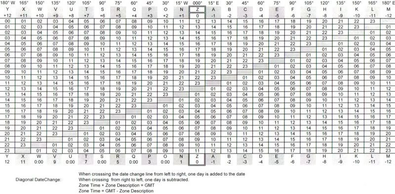
oh, btw, here's GMT converter used by USN
__________________
[SIGPIC][/SIGPIC] During times of universal deceit, telling the truth becomes a revolutionary act. ~ George Orwell |
|
|
|
|
01-06-08, 09:06 PM
|
#115 |
|
Soundman
 Join Date: Aug 2006
Posts: 143
Downloads: 75
Uploads: 0
|
I tried the RealNavMod and it crashed my game with NSM, RFB, and RSDC -
I would simply love to remove the dot from my NAV Map, even if I can't get all the other stuff to work. Does anybody know how to do this? I tried dissecting the RealNavMod and couldn't get it to work. Thanks, Notewire. |
|
|
|
|
01-06-08, 10:19 PM
|
#116 | |
|
Seaman
 Join Date: Dec 2007
Location: B.C. Canada
Posts: 36
Downloads: 13
Uploads: 0
|
Quote:
but when I open any of them it's just plain black and no symbol. I'm sure that has to do with some sort of alpha layer or something but I don't know how to work with them. Any help would be much appreciated, thanks. |
|
|
|
|
|
01-06-08, 10:35 PM
|
#117 |
|
Seaman
Join Date: Dec 2007
Location: B.C. Canada
Posts: 36
Downloads: 13
Uploads: 0
|
Alright, thanks to CaptainCox I've learned how to work with alpha channels. I was correct, the map icons are found where I said they were. Here's CaptainCox tutorial on alpha channels; http://www.subsim.com/radioroom/showthread.php?t=112868
So all you will have to do is make UnitSub.dds, UnitSubL.dds, and UnitsSubM.dds blank and it should work. I haven't tried yet but I think that's all you will have to do. You'll need the DDS Utilies to open and save .dds you can find a skinning tutorial (again by CaptainCox) that has a link to the DDS Utilities and how to use it here; http://www.subsim.com/radioroom/showthread.php?t=109862 |
|
|
|
|
01-07-08, 07:11 PM
|
#118 |
|
Sea Lord
Join Date: Jun 2006
Location: Somewhere else now
Posts: 1,738
Downloads: 825
Uploads: 4
|
Hi girls, I'm back
Gee, quite a conversation going on. If its OK I'll rejoin you guys that have continued this mod into SH4. I still have to put a bit of time into it. If nobodyy's done it yet I'll put time into the different base reference times ? I remember back in patch 1 that these times were different. more later 
|
|
|
|
|
01-08-08, 01:02 AM
|
#119 | |
|
Seaman
Join Date: Dec 2007
Location: B.C. Canada
Posts: 36
Downloads: 13
Uploads: 0
|
Here you go Notewire, I made this mod to remove the circle sub marker from the map;
http://files.filefront.com/No+sub+on.../fileinfo.html Quote:
|
|
|
|
|
|
01-08-08, 03:19 AM
|
#120 |
|
Ace of the Deep
Join Date: Dec 2004
Location: Valhalla: Silent Generation
Posts: 1,149
Downloads: 910
Uploads: 0
|
Hey Van, welcome back. Dang straight! Jump on this puppy, we need an accurate, workable sextant, and you're the action guy for sure
__________________
[SIGPIC][/SIGPIC] During times of universal deceit, telling the truth becomes a revolutionary act. ~ George Orwell |
|
|
|
 |
|
|


 Linear Mode

