
|
|
SUBSIM: The Web's #1 resource for all submarine & naval simulations since 1997
|
SUBSIM: The Web's #1 resource for all submarine & naval simulations since 1997 |
 04-20-22, 07:55 AM
|
#31 | |
|
CTD - it's not just a job
Join Date: May 2016
Location: One hour from Music City USA!
Posts: 10,100
Downloads: 451
Uploads: 2


|
Quote:

__________________
"...and bollocks to the naysayers" - Jimbuna |
|

|

|
|
04-20-22, 08:10 AM
|
#32 |
|
GLOBAL MODDING TERRORIST

Join Date: Sep 2014
Posts: 5,654
Downloads: 137
Uploads: 0


|
As propbeanie said. Take a look at E141S002 for a perfect example of overlap issues.
And that is in a stock BFD! |
|
|
|
|
04-20-22, 08:17 AM
|
#33 | |
|
CTD - it's not just a job
Join Date: May 2016
Location: One hour from Music City USA!
Posts: 10,100
Downloads: 451
Uploads: 2
|
Quote:

__________________
"...and bollocks to the naysayers" - Jimbuna |
|
|
|
|
|
04-20-22, 08:29 AM
|
#34 |
|
GLOBAL MODDING TERRORIST
Join Date: Sep 2014
Posts: 5,654
Downloads: 137
Uploads: 0
|
 
|
|
|
|
|
04-20-22, 10:06 AM
|
#35 |
|
中国水兵
 Join Date: Jun 2019
Posts: 277
Downloads: 558
Uploads: 0
|
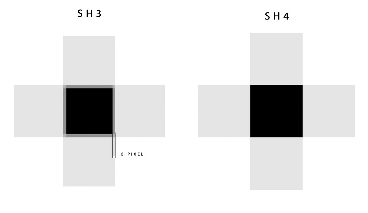
There is one iron rule in editing with GWX SH4TerrainEX. It should be written in red letters - Never edit already redone squares!!!
This will lead to what you wrote about. However, this is also fixable. It just takes a little fiddling around. But never edit what has been changed. The best way out is to redo the square yourself or apply the converted square to the native one and convert it. But I wouldn't risk it. Taking the square out of the game, we are already violating its integrity. If you do this many times, then voids appear. I call them Wandering Pixels. That's why I never use the same square twice. 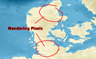
Last edited by astvitaliy1982; 04-20-22 at 10:17 AM. |
|
|
|
|
04-20-22, 10:28 AM
|
#36 |
|
中国水兵
Join Date: Jun 2019
Posts: 277
Downloads: 558
Uploads: 0
|
When you take a stock square, edit it, put it in "color indexed" mode, and
press "Save as RAW", then the Title should be equal to - 0. 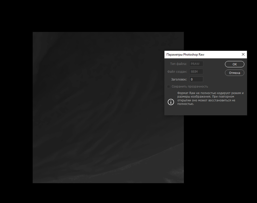
Last edited by astvitaliy1982; 04-20-22 at 12:37 PM. |
|
|
|
|
04-20-22, 11:50 AM
|
#37 |
|
中国水兵
Join Date: Jun 2019
Posts: 277
Downloads: 558
Uploads: 0
|
|
|
|
|
|
04-20-22, 02:58 PM
|
#38 |
|
GLOBAL MODDING TERRORIST
Join Date: Sep 2014
Posts: 5,654
Downloads: 137
Uploads: 0
|
We edited E141S002 a few days ago.
Your image of 'wandering pixels' is to small to see any detail. Only time I've seen that is when one does not remove the header when exported from the ZHF file. No need to do that if exported directly from the BFD file. It may be possible to edit the TerrainMapPS.fx and TerrainMapVS.fx Shader files to change how the Navigation map appears in Game. I removed both as a test and lost all land masses! |
|
|
|
|
04-20-22, 04:07 PM
|
#39 |
|
中国水兵
Join Date: Jun 2019
Posts: 277
Downloads: 558
Uploads: 0
|
I was just one step away from the perfect map. I have a map with a colored depth gradient. Is there a way to replace the color palette of a photo with the one we need? (0-47) I know Phyton can do it. But I can't find a user manual...
|
|
|
|
|
04-20-22, 04:36 PM
|
#40 |
|
GLOBAL MODDING TERRORIST
Join Date: Sep 2014
Posts: 5,654
Downloads: 137
Uploads: 0
|
Try changing the picture as if you doing a RAW file.
|
|
|
|
|
04-20-22, 04:51 PM
|
#41 |
|
GLOBAL MODDING TERRORIST
Join Date: Sep 2014
Posts: 5,654
Downloads: 137
Uploads: 0
|
Only way I can reproduce 'Wandering Pixels' is to NOT remove header information when exporting from a saved ZHF file.
Now you only remove the header information 1 time! So any more opening of a saved RAW file as you work on it? DO NOT have the 4 bytes removed! |
|
|
|
|
04-20-22, 04:52 PM
|
#42 |
|
中国水兵
Join Date: Jun 2019
Posts: 277
Downloads: 558
Uploads: 0
|
Ok. I've been thinking... No matter how I implement this method, it will still be based on intuition... Either I do it visually by comparing pictures, or I do it by going over mathematical formulas based on approximate analysis... The result will not be 100%. But... The depths in the game will now matter... I'm going to get a bottle of beer for inspiration and get to work...)
|
|
|
|
|
04-20-22, 04:56 PM
|
#43 |
|
GLOBAL MODDING TERRORIST
Join Date: Sep 2014
Posts: 5,654
Downloads: 137
Uploads: 0
|
We can ONLY work in the limits the Hard Code allows.
And I'll have a beer with you My Friend! 
|
|
|
|
|
04-20-22, 05:25 PM
|
#44 |
|
CTD - it's not just a job
Join Date: May 2016
Location: One hour from Music City USA!
Posts: 10,100
Downloads: 451
Uploads: 2
|
Make mine a sarsaparilla!!! Unless, of course, you like mogwai gremlins and their water reaction, 'cause that's the way I react to beer... lol
__________________
"...and bollocks to the naysayers" - Jimbuna |
|
|
|
|
04-21-22, 02:22 AM
|
#45 |
|
中国水兵
Join Date: Jun 2019
Posts: 277
Downloads: 558
Uploads: 0
|
I want to share with you one observation in SH3TerrainEX,
but I don't know which branch to put it in. When building lakes, I had one problem. Since the world in SH3 is flat and the terrain is based on a real map, that is observed in such not beautiful situation. 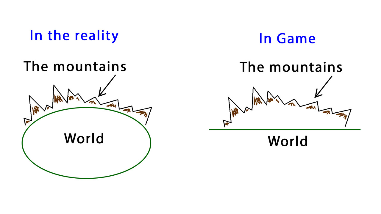 A) If you build a lake in the depths of the mainland, then the relief is too high. And if in the center of the lake will be islands, then when building a depth map (in certain places) they will turn into huge rocks coming out of the water. 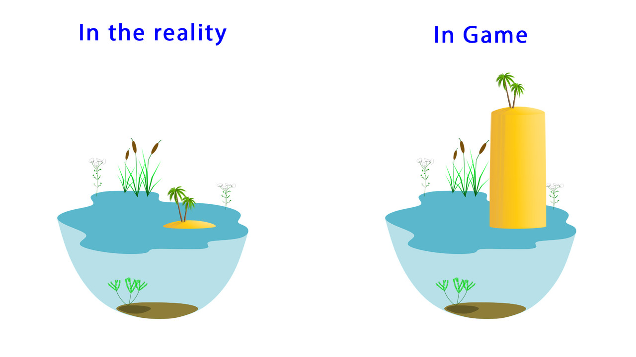 What I do in this case... The area on the editable "Depths" square where the lake will be located, I completely paint over with shades of sushi of small heights. // Heights in m 48 - 0x40800000 = 4.0 49 - 0x40a00000 = 5.0 50 - 0x40c00000 = 6.0 51 - 0x41000000 = 8.0 1) I throw this "Depths" square into the game without building a height map. 2) Run it in game via JSGME and make sure it is replaced (in Sh3Mission Editor) 3) I build a map of "Heights" and also throw them into the game. Again I check through JSGME, and make sure that it has been replaced in the Sh3Mission Editor. Depths at this moment are all equal -16.0 ( Table // 92 47 - 0xc1800000 = -16.0) 4) I throw in the "Depths" square those depths that I need. But! The height of the islands with this manipulation, remains the same as I did in point 1. I can't explain it in programming language, but with SH3TerrainEX you can build, add and edit heights in the game. I did this method on the construction of lakes Venern and Vättern, Ladoga and Onega lakes. Last edited by astvitaliy1982; 04-21-22 at 03:18 AM. |
|
|
|
 |
|
|


 Linear Mode

