
|
|
SUBSIM: The Web's #1 resource for all submarine & naval simulations since 1997
|
SUBSIM: The Web's #1 resource for all submarine & naval simulations since 1997 |
 12-02-10, 01:38 PM
|
#31 |
|
Planesman
 Join Date: Apr 2010
Location: Phoenix Arizona
Posts: 195
Downloads: 290
Uploads: 0
|
I want to develop a land, sea and air simulator and it seems that FlightGear is a good start. It is open source and there are (or were) attempts to combine all three sims discussed here http://wiki.flightgear.org/index.php...tion_Resources
So this is my long term project. I have to learn 3d modeling first but its nice to know there is a path to follow.
__________________

|

|

|
|
12-02-10, 04:37 PM
|
#32 | |
|
Fleet Admiral
 
Join Date: Jul 2006
Location: Sydney, Australia
Posts: 17,052
Downloads: 150
Uploads: 8
|
Quote:
|
|
|
|
|
|
12-02-10, 06:41 PM
|
#33 |
|
Planesman
Join Date: Apr 2010
Location: Phoenix Arizona
Posts: 195
Downloads: 290
Uploads: 0
|
The image was placed using the coordinates on the map. I just have to determine which projection they used and then convert it to UTM. The image is here http://174.123.69.202/~subsimc/radio...d.php?t=162195
Actually cant realistically correct a projection problem. Will look for another image.
__________________
Last edited by danzig70; 12-28-10 at 10:08 AM. |
|
|
|
|
12-03-10, 05:26 AM
|
#34 |
|
Fleet Admiral
Join Date: Jul 2006
Location: Sydney, Australia
Posts: 17,052
Downloads: 150
Uploads: 8
|
Most likely a Millers Cylindrical projection.
|
|
|
|
|
12-03-10, 03:14 PM
|
#35 | |
|
Grey Wolf
 Join Date: Feb 2007
Location: CG 96
Posts: 861
Downloads: 22
Uploads: 0
|
Quote:
|
|
|
|
|
|
12-28-10, 10:09 AM
|
#36 |
|
Planesman
Join Date: Apr 2010
Location: Phoenix Arizona
Posts: 195
Downloads: 290
Uploads: 0
|
Added the SH3 map to WorldWind. Once I figure out how SH3 tiles the map, I hope to add those tiles to WW. Hopefully with the KM grid sections.

__________________
|
|
|
|
|
12-29-10, 04:27 PM
|
#37 |
|
Chief of the Boat

 Join Date: Feb 2006
Location: 250 metres below the surface
Posts: 190,630
Downloads: 63
Uploads: 13


|
This could be promising.
__________________
Wise men speak because they have something to say; Fools because they have to say something.
Oh my God, not again!!  |
|
|
|
|
01-27-11, 10:47 AM
|
#38 |
|
Planesman
Join Date: Apr 2010
Location: Phoenix Arizona
Posts: 195
Downloads: 290
Uploads: 0
|
I never said thank you for the positive words, Jimbuna, it means alot. Im working on a good way to edit the config file which has the lat/long for the icon.
Here is a shot of zoomed in to the player icon based in Kiel.  I saw this screenshot for a ship tracker program and thought how could this would be for the Mission Editor. 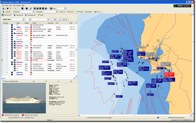 http://www.airnavsystems.com/shiptrax/
__________________
Last edited by danzig70; 02-22-11 at 11:36 AM. |
|
|
|
|
01-28-11, 12:22 PM
|
#39 | |
|
Chief of the Boat
Join Date: Feb 2006
Location: 250 metres below the surface
Posts: 190,630
Downloads: 63
Uploads: 13
|
Quote:

__________________
Wise men speak because they have something to say; Fools because they have to say something.
Oh my God, not again!! |
|
|
|
|
|
03-03-11, 03:58 PM
|
#40 |
|
Planesman
Join Date: Apr 2010
Location: Phoenix Arizona
Posts: 195
Downloads: 290
Uploads: 0
|
So, I am toying with the idea of making a ship tracker per the screenshots below. The idea is to simulate AIS maps like here http://www.marinetraffic.com/ais/ and here http://www.sailwx.info/shiptrack/shiplocations.phtml.
I added map notes to the ME for two test ships that contain origin, destination and cargo, like a manifest. The ships are assigned an ID code as the name when placed on the map. I created two entries in a ship database (xls,csv) that contain detailed information on the ship as well as a link to a photograph (in game or actual). I am trying to simulate activities such as anti-piracy and routine maritime patrols. One thing I want to expand is position reporting of cargo ships like the sites above. The map notes are accessible as entries in the SCR file which is just a text file. The CFG files in My Doc/SH3 can be read as they are also just text files. I am thinking of using Javascript or Lua to read the files. Attacks are logged in the CFG files just fine but I want to be able to simulate reporting on friendly and nuetral traffic. The Report Contacts report, unfortunately, does not seem to write an event in the log book. Can this be modified? When a game is saved, however, it records the circles, angles and marks placed on the navigation map into a temp file that is also a text file. The latitude and longitude of each feature is recorded. I was thinking of using this to record the position of the sighting but if the game is not saved, this file is not created (or saved). I was thinking of trying to simulate pirate and criminal vessels by creating a "pirate" country. Plenty of armed merchants to choose from. If you spot a vessel and ID it using the database, then it could be a pirate vessel which can be sunk. Something like that. Is there a way to either modify the report contact feature to record in the log file or a way to capture map marks without having to save the game? More important, would anyone be interested in such a thing? I thought it might be a nice feature for SH3Commander. I will work on just mapping the sinkings to test the concept. Also, I guess the Cap' would have to fill in the heading and speed information. The tedious part of war, I suppose.
__________________
|
|
|
|
|
03-04-11, 06:52 PM
|
#41 |
|
Chief of the Boat
Join Date: Feb 2006
Location: 250 metres below the surface
Posts: 190,630
Downloads: 63
Uploads: 13
|
Sounds plausable.
__________________
Wise men speak because they have something to say; Fools because they have to say something.
Oh my God, not again!! |
|
|
|
|
03-06-11, 01:35 PM
|
#42 |
|
Planesman
Join Date: Apr 2010
Location: Phoenix Arizona
Posts: 195
Downloads: 290
Uploads: 0
|
I guess it cant run when SH3 is running. But maybe it could be useful for planning purposes and tracking career progress.
__________________
|
|
|
|
|
03-06-11, 05:29 PM
|
#43 |
|
Chief of the Boat
Join Date: Feb 2006
Location: 250 metres below the surface
Posts: 190,630
Downloads: 63
Uploads: 13
|
I use the ME for the former, especially whilst testing but the latter use sounds good.
__________________
Wise men speak because they have something to say; Fools because they have to say something.
Oh my God, not again!! |
|
|
|
|
03-07-11, 08:43 AM
|
#44 |
|
Planesman
Join Date: Apr 2010
Location: Phoenix Arizona
Posts: 195
Downloads: 290
Uploads: 0
|
Some of the lat/long info doesnt appear to be in degrees:
Long=962852.000000 Lat=6974492.000000 Do you know if this is meters from center (equater-meridian)? EDIT: It seems SH3Gen does this already. Oh Well.
__________________
Last edited by danzig70; 03-08-11 at 06:32 PM. |
|
|
|
|
04-29-11, 04:03 AM
|
#45 |
|
Planesman
Join Date: Apr 2010
Location: Phoenix Arizona
Posts: 195
Downloads: 290
Uploads: 0
|
Here are a few screenshots of the user interface Im working on. There is an SH3 icon which links to the game shortcut. Some of the imagery is impressive because you can tilt the camera 360 degrees. Thought submariners might like the bathymetry image.
This is the Bay of Biscay  This is a good example of satellite, aerial and topographic images.  This topographic map is from 1934 so I dont think the Uboat pens have been contructed. I believe they were only in Cadiz, Spain and Abo, Finland. 
__________________
|
|
|
|
 |
|
|


 Linear Mode

