
|
|
SUBSIM: The Web's #1 resource for all submarine & naval simulations since 1997
|
SUBSIM: The Web's #1 resource for all submarine & naval simulations since 1997 |
|
|
 08-20-17, 05:17 AM
|
#1 | |||||||||||||||||
|
Stowaway
Posts: n/a
Downloads:
Uploads:
|
Quote:
Quote:
Quote:
Quote:
Quote:
 Quote:
 Quote:
 Quote:
Quote:
Quote:
PS : What do you mean with FX, SFX and PG's ? Quote:
 Quote:
 Quote:
Quote:
The 'rendering radius' is controlled by the fog parameters. |
|||||||||||||||||

|
|
08-20-17, 09:13 AM
|
#2 | ||||||||||||||
|
Navy Seal
 Join Date: Jan 2011
Location: CJ8937
Posts: 8,215
Downloads: 793
Uploads: 10
|
Quote:
Quote:
 Quote:
 Quote:
 Quote:
 Quote:
SFX = sound effects PG = particle generator Quote:
 Quote:
https://www.mediafire.com/file/5cpmf...ghthouse_FX.7z I also suggest you to copy the light halo material embedded in the same file: it represents a light glow with rays not sticking out from the glow (as in the stock texture), but being part of the glow itself. The effect is best appreciated against a dark background, as the sea surface. Quote:
Quote:
Quote:
Still talkin about SH5, dunno about SHIII and IV, fog parameters are only for player's visual, and they have nothing to do with the actual rendering radius (as far as an unit is within 20 km from the player, it will be treated as a physical object, whether the player can see it or not depending on weather conditions and fog settings). Talking about our mod, I think the highest and most powerful lighthouses emit a light signal that, at best visibility conditions, can be seen as far as 60 km away from their source. I wish our mod to reflect those nominal ranges, but I am afraid that setting in-game rendering/atmosphere radius to 60 km, will be beyond the possibilies of the game engine and of our poor machines. I am wondering what could be a good alternative. Scaling down the ranges by a factor 4-5 maybe, so that the longest ranged lights will be visible from a distance of 15-12 km, and shorter lights as La Plate will be visible within a radius of only 4-5 km? what do you think? 
|
||||||||||||||

|
|
|
08-20-17, 11:26 AM
|
#3 | |
|
Weps
 Join Date: Sep 2002
Location: SW France
Posts: 361
Downloads: 137
Uploads: 0
|
Quote:
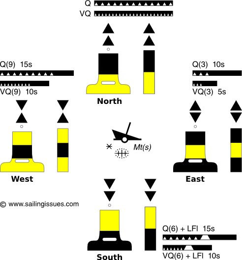
A group of 9 very quick flashes over a 10 second period, 19m high (as you said gap Link to abbreviations and symbols - still searching for 1940's era symbols. http://www.yachter.fr/shom/html5/sym...ndex.html#56/z Regards, MLF
__________________
Je pense donc je fuis! |
|
|
|
|
|
08-20-17, 12:31 PM
|
#4 | |||
|
Navy Seal
Join Date: Jan 2011
Location: CJ8937
Posts: 8,215
Downloads: 793
Uploads: 10
|
Quote:
I have noticed that Hitman had created a 20-km environment mod, but unfortunately the link is down I have also seen that you had a 30-km environment mod planned. Did you make any progress with it? A set of optional long-range environment mods especially developped for this mod would be a cool addition to it, but I am afraid their settings are a bit tricky Quote:
What I have done, is plotting that 8-nm range on a nautical chart. Radius length on map was calculated based on the length of one degree of latitude/longitude at Raz de Sein's latitude. There are many on-line calculators that you can get this data from; I used the one below: http://www.csgnetwork.com/degreelenllavcalc.html The next step was squeezing the nautical chart I was drawing on, so that one minute of latitude was as long as one minute of longitude (as in the SH world). After doing that, La Plate's circular range became an ellipse. I then measured the length of major and minor axes of this ellipse (real range), and I calculated the radius of the best-fitting SHIII range as the square root of the square of ellipse's semimajor axis plus the square of ellipse's semiminor axis. This is the result after drawing the SHIII radius on map: At this point, knowing that in SHIII one minute of latitude/longitude is always equal to 2 km, calculating the desired in-game radius was a simple math. My result is 15,107 metres, with an ecceptable margin of error caused by the approximations used Quote:

|
|||
|
|
|
|
08-20-17, 01:46 PM
|
#5 |
|
Weps
Join Date: Sep 2002
Location: SW France
Posts: 361
Downloads: 137
Uploads: 0
|
If only all these converters were available when I was at sea
I'll resume the search for chart 5011 symbols mid-september. Off and away now Regards, MLF
__________________
Je pense donc je fuis! |
|
|
|
|
08-20-17, 02:10 PM
|
#6 | ||
|
Navy Seal
Join Date: Jan 2011
Location: CJ8937
Posts: 8,215
Downloads: 793
Uploads: 10
|
Quote:
Quote:

|
||
|
|
|
|
08-20-17, 02:38 PM
|
#7 | |
|
Weps
Join Date: Sep 2002
Location: SW France
Posts: 361
Downloads: 137
Uploads: 0
|
Quote:
Thank you gap. regards, MLF
__________________
Je pense donc je fuis! |
|
|
|
|
|
08-26-17, 09:34 AM
|
#8 | |
|
Stowaway
Posts: n/a
Downloads:
Uploads:
|
Quote:
|
|
|
|
|
08-27-17, 09:46 AM
|
#9 |
|
Stowaway
Posts: n/a
Downloads:
Uploads:
|
I've found a photography showing the aspect of La Vieille lighthouse during the 1930-1940s years.
And if it can help you, there are also drawings with precise measures. http://mnesys-portail.archives-finis...he_grandpublic |
|
|
|
08-27-17, 01:03 PM
|
#10 |
|
Weps
Join Date: Sep 2002
Location: SW France
Posts: 361
Downloads: 137
Uploads: 0
|
Admiralty Charts of Scottish coasts, 1795-1963
http://maps.nls.uk/coasts/admiralty_charts_list.html Browsing these gives an idea of chart symbols in use in 1940 on admiralty charts. Regards, MLF
__________________
Je pense donc je fuis! |
|
|
|
|
12-30-18, 10:54 AM
|
#11 | |
|
Machinist's Mate
 Join Date: Jun 2011
Location: N 50 4 E 14 25
Posts: 127
Downloads: 266
Uploads: 0
|
Quote:
If you want 20 km environment, install M.E.P. 6 (im not sure, but i think it was in v. 4.2 and later) http://www.subsim.com/radioroom/show...=229333&page=4 Last edited by JeromeHeretic; 12-30-18 at 11:19 AM. |
|
|
|
|
|
12-30-18, 12:24 PM
|
#12 |
|
Navy Seal
Join Date: Jan 2011
Location: CJ8937
Posts: 8,215
Downloads: 793
Uploads: 10
|
Hi guys, sorry for the late replies,
unfortunately Kendras can't answer any longer on this thread since, apparently, an infraction by him was sanctioned with what now seems a permanent ban from subsim. You can get in touch with him on his personal forum: http://kendras-sh3-modding.forumactif.com/ Since our last update here, we have made little progress with this mod: the Ile-de-Sein was added to the SHIII world (though I think Kendras wasn't too happy with its last layout), new lighthouse icons have been created, and together with several unfinished lighthouse models, I have worked on a port light model that I sent to Kendras for him to add it to the French ports. After that, there was a long stand-by caused by real life engagements. As some of you already know, I have now started a new project for SH5 which deals mostly with therrain/tree textures, but among its features there are also terrain shape improvements, more realistic ports, and the modelling of natural and human-made landmarks, including daymarks and lighthouses. I am in constant touch with Kendras, and be sure that whatever I do will be passed on to Kendras for porting to SHIII @ Seaowl: Glad to read your comments on this thread too! @ JeromeHeretic: Thank you for your information mate. I will save it for future reference. In the meanwhile you might find interesting the following website gathering information on lighthouses worldwide: https://www.ibiblio.org/lighthouse/
|
|
|
|
|
12-30-18, 05:22 PM
|
#13 |
|
Machinist's Mate
Join Date: Jun 2011
Location: N 50 4 E 14 25
Posts: 127
Downloads: 266
Uploads: 0
|
Registration to forum doesn't work to me. E-mail with code never come...
BTW: Also exist 20km unfficial patch for GWX: ftp://Maik:Woelfe@hartmuthaas.no-ip....phere_Unood.7z Try it too... Im not sure now, but i have strong feeling, that in one, or in second environment is not changed values for visibility in binoculars and so (it's in zones.cfg i think.. not sure when i try remember now). So... in case of some problems you can diff this files and get correct one, or just change needed values. And THX for that link, but i already know it. :-) I have ready list with about 2000 lighthouses (but still there are bugs, i know it and slowly repairing) and written scripts for automatic generating of LND.mis, locations.cfg, SCR.mis. (because script recognition lightouses and lightboats) I'm only waiting if you both will finish some more lighthouses, so i can generate world with different lighthouses on different places. Now i'm using just one lighthouse and GWX lightboats. When we are talking about this, i have few ideas, but i don't know how to do it. Sure it is possible, but maybe it is needed for every mutation add new dat file to game, so only some reduced amount of variations is possible to add to game. But if it is possible, i think it will be enough even in this reduced form. I was looking to previously posted page: http://www.sailingissues.com/navcourse9.html and i got idea, that i like to have: - Lighthouse with red light (as a marker to port side of route into the ports) - I think, that "common" lighthouse used in game can be lighthouse which i have, with normal, long blinking white light. But on the long coastal lines, where are a lot of lighthouses in some distances i want sometimes some specific lighthouse, from which i can recognize where exactly i am. I know it already from transatlantic travels, that error of my position after transatlantic route is so big, that even if i find a lighthouse on horizont, im never sure which one it is... So... idea is have few "morse" blinking lighthouses. I think that 4 "bit" table must be enough for everyone. So when we look into morse code table, there are this possibilities for lighthouses: B -... C -.-. F ..-. H .... L .--- Q --.- V ...- X -..- Y -.-- Z --.. With lighthouse which i already have (lets call him "slow blinker") and when can be speed of blinking changed to quick, we have table of 12 unique lights (+ red one)! So when i get the markings from that page, we can have FL, Q, MoB, MoC, MoF, MoH, MoL, MoQ, MoV, MoX, MoY, MoZ and Iso R. Now question for you is, if it is possible? (Im sure just only about changing color of light, even if i don't know how to do it.) EDIT: Ah yes, i almost forget. In GWX are tugboats near lightboats. This is not looking much realistic, but it is great idea, because when you go on high TC and watch crew see a ship, TC falls to 1, so you know that you are near that lightboat! Would be nice, if can be implemented, that watch crew reactions on lighthouse is the same as for ship. (Daesn't matter if crew say "ship spotted", it's not important that lighthouse is not a boat, is important, that i know about it and that TC falls to 1) Is this possible? (Im afraid not... because it is "land unit", but better ask, than be silent and lost this functionality if it is possible) Last edited by JeromeHeretic; 12-31-18 at 09:05 AM. |
|
|
|
 |
| Thread Tools | |
| Display Modes | |
|
|


 Hybrid Mode
