
|
|
SUBSIM: The Web's #1 resource for all submarine & naval simulations since 1997
|
SUBSIM: The Web's #1 resource for all submarine & naval simulations since 1997 |
|
|
 06-07-17, 02:53 PM
|
#1 |
|
Stowaway
Posts: n/a
Downloads:
Uploads:
|
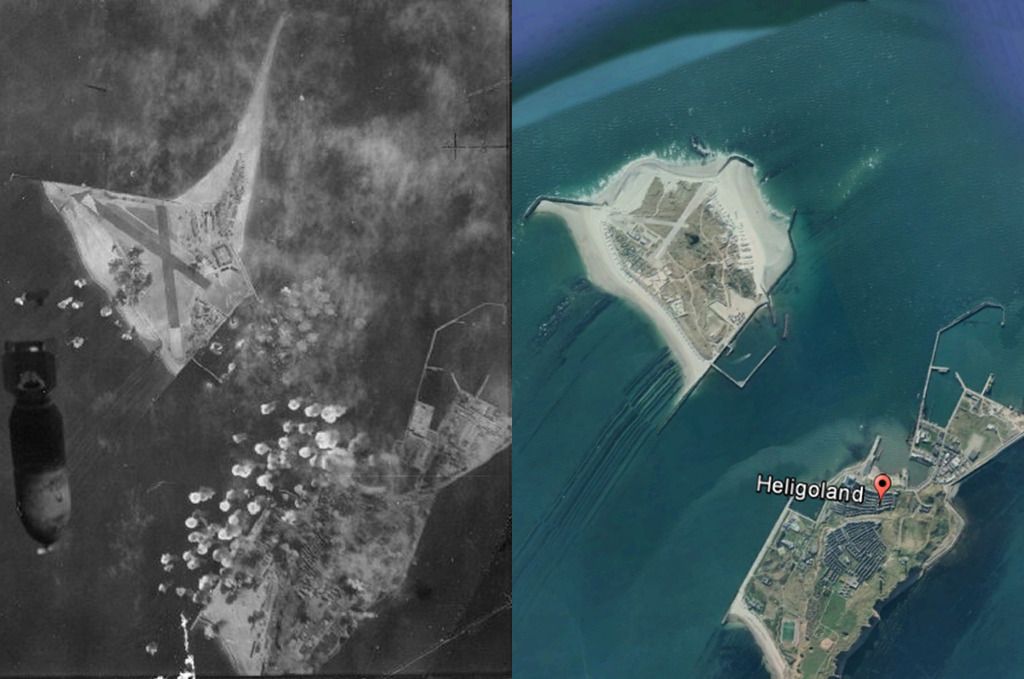
Something interesting : http://www.kartengruppe.it/immagini/...0/0088G-SB.jpg (from : http://www.kartengruppe.it/index.php/nordsee-deutsche-admiralitatskarten)
But although the map was printed in 1943, it's based on a 1913 map. In 1943, the island was bigger, as you can see on this picture : 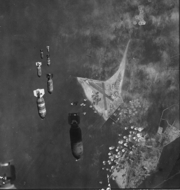
Last edited by Kendras; 06-07-17 at 03:03 PM. |

|
|
06-07-17, 03:32 PM
|
#2 | |
|
Stowaway
Posts: n/a
Downloads:
Uploads:
|
Quote:
|
|
|
|
|
06-07-17, 05:12 PM
|
#3 | ||
|
Navy Seal
 Join Date: Jan 2011
Location: CJ8937
Posts: 8,215
Downloads: 793
Uploads: 10
|
Quote:
Quote:
 I don't know how far the Nazis went with their expansion plan, anyway the sandy beaches of Helgoland and Düne are subject to a strong tidal erosion, and their size and shape might have changed over time. Add to that the fact that after war the Brits tried to sink the main island |
||

|
|
|
06-07-17, 06:53 PM
|
#4 | |
|
Navy Seal
Join Date: Jan 2011
Location: CJ8937
Posts: 8,215
Downloads: 793
Uploads: 10
|
Quote:
|
|
|
|
|
|
06-08-17, 04:44 PM
|
#5 |
|
Navy Seal
Join Date: Jan 2011
Location: CJ8937
Posts: 8,215
Downloads: 793
Uploads: 10
|
I have outlined the two islands of Helgoland and Dune on an equirectangular map projection (as the one used in SH games to represent the globe)...
 and I have placed them on a 1deg lat/long quadrant of the size used for SHIII terrain masks. This is the result:  The resolution is poor indeed, but those are the limits imposed by the game. 
|
|
|
|
|
06-09-17, 07:06 PM
|
#6 | |
|
Stowaway
Posts: n/a
Downloads:
Uploads:
|
Quote:

|
|
|
|
|
06-09-17, 07:57 PM
|
#7 | |
|
Navy Seal
Join Date: Jan 2011
Location: CJ8937
Posts: 8,215
Downloads: 793
Uploads: 10
|
Quote:
 Jokes apart, any other shape would cause a misalignment of the islands relative to the in-game coordinate system both in terms of latitude/longitude and KM quadrant and, due to the small size of the two island and the low resolution of SHIII terrain masks, the difference in terms of "good shape" would be hardly detectable anyway 
|
|
|
|
|
|
06-10-17, 08:53 AM
|
#8 |
|
Stowaway
Posts: n/a
Downloads:
Uploads:
|
This is the shape I mean (with the lighthouses' positions) :

Last edited by Kendras; 06-10-17 at 03:02 PM. |
|
|
|
06-10-17, 10:16 AM
|
#9 |
|
Stowaway
Posts: n/a
Downloads:
Uploads:
|
Other pictures of Helgoland :
   
Last edited by Kendras; 06-10-17 at 10:48 AM. |
|
|
 |
| Thread Tools | |
| Display Modes | |
|
|


 Hybrid Mode
