
|
|
SUBSIM: The Web's #1 resource for all submarine & naval simulations since 1997
|
SUBSIM: The Web's #1 resource for all submarine & naval simulations since 1997 |
|
|
 10-28-12, 01:10 PM
|
#1 | |
|
Lieutenant
 Join Date: Jan 2012
Posts: 252
Downloads: 66
Uploads: 0
|
Quote:
Chart of the coasts of Biscaya were new. The rest were already known. Unfortunately the sharpness of the Biscaya-map are not the best.
__________________
Robert Schmidt, LTJG U-43 |
|

|

|
|
10-31-12, 07:32 AM
|
#2 | |
|
Loader
 Join Date: Apr 2010
Location: Italy
Posts: 85
Downloads: 17
Uploads: 0
|
Quote:
But don't worry, here another unpublished kriegsmarine map of the English Channel - Dover Strait (20 mb): 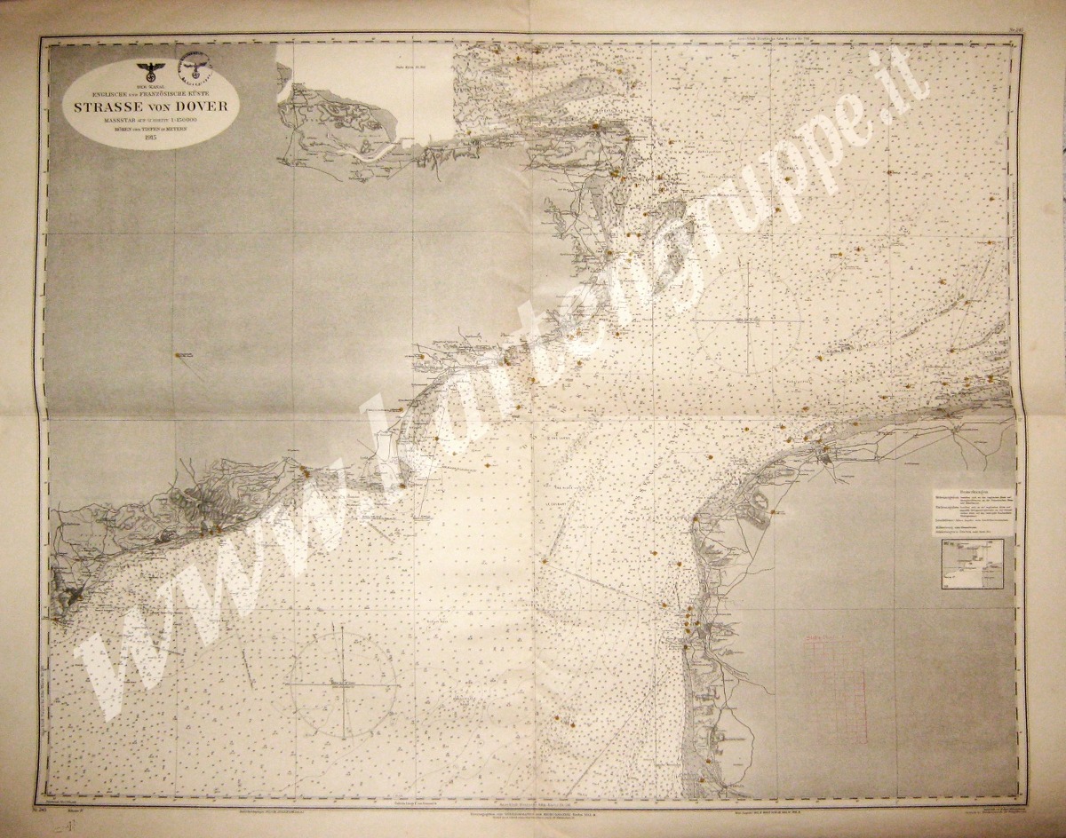 D.Adm. 245 Der Kanal - Englische und Franzosische Küste STRASSE VON DOVER 1:150.000, 1943 (su modello del 1915) Klasse IV, 105 x 85 cm Note: Map with circular stamp "Kriegsmarinewerft Kiel Kartengruppe" on the front and with back printed with title and stamp I made it from scan => Download it ! www.kartengruppe.it PS: this is for you and as a present to my friend Fernando |
|
|
|
|
|
10-31-12, 08:41 AM
|
#3 |
|
Navy Seal
 Join Date: Jan 2011
Location: CJ8937
Posts: 8,215
Downloads: 793
Uploads: 10
|
Thank you again Pino for sharing these outstanding maps. Some of the ones you have recently posted are password protected though

|
|
|
|
|
10-31-12, 08:48 AM
|
#4 |
|
Ocean Warrior
 
Join Date: Feb 2012
Location: Rostov-on-Don, local time GMT+4
Posts: 3,300
Downloads: 374
Uploads: 0

|
password is - kartengruppe.it

__________________
. Where does human stupidity end? .   El sueño de la razón produce monstruos © - and for some people awakening will be cruel |
|
|
|
|
11-01-12, 04:32 PM
|
#5 |
|
Lieutenant
Join Date: Jan 2012
Posts: 252
Downloads: 66
Uploads: 0
|
Excellent quality. A musthave for every captain operating in the eastern british coastal waters
__________________
Robert Schmidt, LTJG U-43 |
|
|
|
|
11-17-12, 06:16 AM
|
#6 |
|
Loader
Join Date: Apr 2010
Location: Italy
Posts: 85
Downloads: 17
Uploads: 0
|
On my site I've updated (neither download, I'm sorry) 15 new Kriegsmarine maps concerning Pacific Ocean:
Stiller Ozean (Ozeankarten) - D.Adm. 404 STILLER OZEAN - Westlicher Teil, Südblatt; - D.Adm. 404a ANSATZKARTE ZU STILLER OZEAN - Westlicher Teil, Südblatt (new!); - D.Adm. 406 STILLER OZEAN - Mittlerer Teil, Südblatt; - D.Adm. 406 STILLER OZEAN - Mittlerer Teil, Südblatt, RMAmt (new!); Ostindischer Archipel, Südchinesisches Meer, Inselgruppen bis 180°: - D.Adm. 634 MARSCHALL INSELN, MARIANEN, KAROLINEN UND BISMARK ARCHIPEL; Ostchinesisches, Japansches, Ochotskisches Meer: - D.Adm. 299 OST-CHINESISCHES MEER (new!); Ostchinesisches, Japansches, Ochotskisches Meer (segelkarten): - D.Adm. 554 TSUSHIMA STRASZE; Ostchinesisches Meer mit Taiwan- u. Nansei Inseln: - D.Adm. 158 KIATSCHOU BUCHT; Marianen, Karolinen, Marschallinseln und Inselngruppen bis 180°: - D.Adm. 180 PALAU INSELN (new!); - D.Adm. 409 JAP INSELN (new!); - D.Adm. 601 PLÄNE DER MARIANEN, BLATT I (new!); - D.Adm. 602 PLÄNE DER MARIANEN, BLATT II; - D.Adm. 604 PLÄNE DER OST KAROLINEN, BLATT I (new!); Südlicher Stiller Ozean (Gesamtgebiet): - D.Adm. 609 SALOMON INSELN (new!); - D.Adm. 257 SAMOA INSELN (new!); Ostküste von Australien: Kap York bis Brisbane, Inselgruppen bis 120° W: - D.Adm. 395 BOUGAINVILLE Nord Westlicher Teil (new!); - D.Adm. 546 TINPUTZ- UND TOEP HAFEN (new!); - D.Adm. 394 BOUGANVILLE STRASZE; - D.Adm. 430 HAFEN VON KIETA (new!); - D.Adm. 258 INSEL UPOLU; - D.Adm. 258 INSEL UPOLU RMAmt (new!); - D.Adm. 259 ANSTEUERUNG ZUM APIA HAFEN (new!); - D.Adm. 519 INSELN SAVAI'I (new!); Westküste von Südamerika: Valparaiso bis Kap Hoorn, Juan Fernandez Inseln: - D.Adm. 786 CORRAL BUCHT. by www.kartengruppe.it . |
|
|
|
 |
| Tags |
| enigma, kriegsmarine, marinequadratkarte, oberkommando, seekarte |
| Thread Tools | |
| Display Modes | |
|
|


 Hybrid Mode
