
|
|
SUBSIM: The Web's #1 resource for all submarine & naval simulations since 1997
|
SUBSIM: The Web's #1 resource for all submarine & naval simulations since 1997 |
|
|
 09-24-12, 06:25 PM
|
#1 | |
|
Ace of the Deep
 Join Date: Jan 2010
Location: Vancouver, BC, Canada
Posts: 1,183
Downloads: 225
Uploads: 0

|
Quote:
|
|

|

|
|
09-24-12, 07:19 PM
|
#2 |
|
Eternal Patrol
 Join Date: May 2004
Location: Aeoteroa
Posts: 7,382
Downloads: 223
Uploads: 1
|
This would be great!

|
|
|
|
|
09-25-12, 03:40 AM
|
#3 |
|
Frogman
 Join Date: Apr 2005
Posts: 308
Downloads: 724
Uploads: 0
|
Looks really good, i forward this

__________________
 |
|
|
|
|
09-25-12, 05:38 AM
|
#4 |
|
XO
 Join Date: Sep 2007
Location: looking in the bilge for a bottle opener
Posts: 416
Downloads: 210
Uploads: 0
|
Looks like a really good idea.
It would be great if you had an 'end mission at sea' function maybe 100kms from port like in the other Silent Hunter games. This would also be good for those with older computers, who have problems with ctd's close to port. Off topic: why the crashes occur going into port more than going out of port? I'm just curious. |
|
|
|
|
09-28-12, 07:33 AM
|
#5 |
|
Captain
 Join Date: May 2005
Location: Kassel, Germany
Posts: 542
Downloads: 345
Uploads: 0
|
Hello,
I've made a first test with a route from Wilhelmshaven to somewhere near the Faroe Islands. I think it works fine, but I cannot travel with a TC above 512. The game misses the next waypoint and Your sub goes straight ahead until You will stop it.  In the screenshot below You see, that I haven't started the route frome Wilhelmshaven. I have entered it from the Skagerrak. I went there with the Skagerrak-pilot from Kiel. I have activated the Marschweg-Autoscript and the sub found the nearest waypoint there and headed to NE. 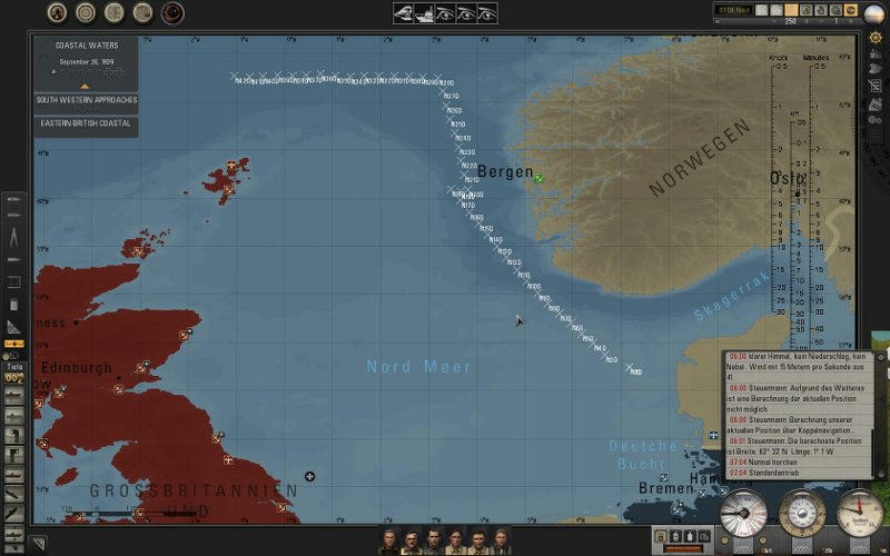 Near Bergen, I have travelled with TC 1024 and the Pilot missed the next WP. So I deactivated and reactivated the scipt on a low TC and it found the next one and resumed the given route. The parameters for th sha-file are: Code:
[TITLE] Marschweg [TITLE_END] [DESCRIPTION] Ihr Steuermann lässt das Boot auf diesem Weg in das befohlene Zielgebiet marschieren [DESCRIPTION_END] [PRECONDITION] 0,0,0 [PRECONDITION_END] [WAYPOINT_RESUME] 50000 [WAYPOINT_RESUME_END] [BUFFERZONE] 2000,0,2,3,1000,3,2,1 [BUFFERZONE_END] [WAYPOINTRADIUS] 1000,2000 [WAYPOINTRADIUS_END] 980887,6427730,-1,9999,9999,9999,-1,Start 970000,6445000,-1,9999,9999,9999,-1,WP 1 960000,6500000,-1,9999,9999,9999,-1,WP 2 950000,6600000,-1,9999,9999,9999,-1,WP 3 920000,6700000,-1,9999,9999,9999,-1,WP 4 .... The testversion with this route: http://www.mediafire.com/?5a768oo2o45j6br Because it is dull to work with the Mission-Editor for finding the needed waypoints, I'll need some help from You  The game messures from x-achse -21 600 000 metres to -21 600 000 -> 43 200 000 metres=pixel and y-achse -10 800 000 metres to -10 800 000. -> 21 600 000 metres=pixel I have converted the large map file into a bmp file. But I got an ugly picture where I cant distinguish land from water. Perhaps someone could convert this file for me. I want to draw the lines in this picture for getting the x- and y-position ingame. I think the resolution from 1 pixel = 2000 m is exactly enough for defining the sub-routes. If needed, I have an 80 MB PSD File from this map. Please PM me for the link. Thanks, Paco.
__________________
My SH5-Mods: - Pacos German Folklore SubEmblems Mod - Pacos Environment Sound Mod - Lite Campaign German Edition |
|
|
|
|
09-28-12, 02:07 PM
|
#6 | |
|
Navy Seal
 Join Date: Apr 2007
Location: AN1536 (Orkney)
Posts: 5,451
Downloads: 166
Uploads: 28

|
Hi Paco - looking good so far
 Some point to consider:- [BUFFERZONE] 2000,0,2,3,1000,3,2,1 Here the first param is the detection radius for a warning message You could use this as your lookout calling a contact. If you set this at say 5000 or 6000 and then set param 3 to 2 and param 4 to 9999 - the result would be:- A ship within 5 to 6km will cause TC to drop to x1 and a message to display and speed to remain the same. This could be a nice way to let us retake control of the boat if the ship is a target  Quote:
An easy way to get the coords is to run your script with the game in windowed mode. At the same time run dbview as it will give you lots of info anout what navigation is doing. So as each leg runs through - dbview will give you constant feedback as to how far to the next way point check (x4 for non precision). When you are at the halfway point - get a new fix from the nav officer and insert that into your script. Do try to run dbview at the same time as it helps a lot
|
|
|
|
|
|
09-29-12, 04:17 AM
|
#7 |
|
Captain
Join Date: May 2005
Location: Kassel, Germany
Posts: 542
Downloads: 345
Uploads: 0
|
Thanks Trevally, that helps me a lot.
 What am I doing now? I'm writing a script in Python which is calculating the waypoints between, I called them, masterpoints. Masterpoints are waypoints where the heading of the sub will change. I hope, that I will finish the work with this script in a few days. I want to have the following features:
I know, that needs some time to do this, but I think, for later tests and modifications it makes sense. We are able to define the masterpoints in a textfile and the script will do the calculation for the needed SHN-file. After that, we are doing tests with different speeds and TCs and if we'll get in trouble, we'll change the Parameters for distances and will doing a recalculation for the files. Over all, I think this method will decrease time to build new routes. It will be easy to define long-range routes with only a few given masterpoints and the scipt hopefully will do the rest for us. Ah, the script does this calculation not ingame! Its only for building the files before releasing the mod or for building new routes befor activating them via JSGME. Greetings, Paco.
__________________
My SH5-Mods: - Pacos German Folklore SubEmblems Mod - Pacos Environment Sound Mod - Lite Campaign German Edition Last edited by Paco; 09-29-12 at 04:53 AM. Reason: fixed typing errors |
|
|
|
 |
| Thread Tools | |
| Display Modes | |
|
|


 )
)


 Hybrid Mode
