
|
|
SUBSIM: The Web's #1 resource for all submarine & naval simulations since 1997
|
SUBSIM: The Web's #1 resource for all submarine & naval simulations since 1997 |
|
|
 04-06-11, 02:24 PM
|
#1 |
|
Loader
 Join Date: Apr 2010
Location: Italy
Posts: 85
Downloads: 17
Uploads: 0
|
Hi, thanks for the interest
The maps are so big for high resolution photo. I have scanned some of them for a personal use but it's so expensive and it can wrap them. ... but I think in the next days I'll add some for all the users Nice to meet you Pino |

|

|
|
04-06-11, 03:39 PM
|
#2 | |
|
中国水兵
 Join Date: Dec 2010
Posts: 278
Downloads: 91
Uploads: 0
|
Quote:
I mean i ask for to pick up a cheap 5MB-resolution camera and make some close-ups of the map, so we have lets say 15 photoshots for each map. A compilaton of these 15 pictures to one huge picture is not necessary. IMO details is that what counts. If we have maps but cannot read the water depth, cannot identify light-house positions and cannot identify the coastline (mountains etc.) then these maps are just decoration and useless. |
|
|
|
|
|
04-07-11, 09:28 AM
|
#3 | |
|
Loader
Join Date: Apr 2010
Location: Italy
Posts: 85
Downloads: 17
Uploads: 0
|
Quote:
I made so much ... I have a scan of the map so I have uploaded an high resolution pdf file I just added a little transparent watermark You may find it on: http://www.mediafire.com/?vfd9008hu2jccsl It's compressed on 20Mb jpg format (as the original .tif was about 200 mb). The file is about 8100*6100 pixel, 200 dpi! For your funny Pino PS: For all the users, please visit my site http://www.kartengruppe.it |
|
|
|
|
|
04-07-11, 10:17 AM
|
#4 |
|
Sea Lord
 Join Date: Mar 2010
Posts: 1,845
Downloads: 184
Uploads: 2
|
Speaking about maps.. does anyone know a mine map used in ww2? I know where mines were used in north sea, but where else?
|
|
|
|
|
04-07-11, 03:24 PM
|
#5 | ||
|
Ace of the Deep
Join Date: Oct 2006
Posts: 1,151
Downloads: 152
Uploads: 0

|
Quote:
 Of course we now expect all your maps uploaded like that!  Quote:
|
||
|
|
|
|
04-07-11, 05:22 PM
|
#6 | |
|
中国水兵
Join Date: Dec 2010
Posts: 278
Downloads: 91
Uploads: 0
|
Quote:
I am also interested in some books, for example this one, the nautic almanac from 1938 => "Nautisches Jahrbuch oder Ephemeriden und Tafeln für das Jahr 1938 zur Bestimmung der Zeit, Länge und Breite zur See nach astronomischen Beobachtungen. Siebenundachtzigster Jahrgang, in ottavoNote: Berlin Carl Heymanns 1937" |
|
|
|
|
|
04-10-11, 03:41 AM
|
#7 |
|
Loader
Join Date: Apr 2010
Location: Italy
Posts: 85
Downloads: 17
Uploads: 0
|
hi, here another kriegsmarine nautical chart uploaded!
It's the D.Adm. 516 Atlantischer Ozean - KAP VERDE BIS PERNAMBUCO 1:3.000.000, 1942, Klasse IV, 80 x 109 cm related to the follow area  download her from here ->"D.Adm.516_Kriegsmarine_Map_by_Kartengruppe.it"<- and please visit my site www.kartengruppe.it ... and have fun! by Pino |
|
|
|
|
04-10-11, 09:35 AM
|
#8 | |
|
中国水兵
Join Date: Dec 2010
Posts: 278
Downloads: 91
Uploads: 0
|
Quote:
Thank you very much. The scan-qualitiy is so extraordinary and the map is fantastic. |
|
|
|
|
|
04-10-11, 12:17 PM
|
#9 | |
|
Ace of the Deep
Join Date: Oct 2006
Posts: 1,151
Downloads: 152
Uploads: 0
|
Quote:
 Thank you very much for sharing, Pino! |
|
|
|
|
|
01-27-12, 12:02 AM
|
#10 |
|
Crusty
 Join Date: Jun 2005
Location: USA
Posts: 649
Downloads: 334
Uploads: 0
|
Awesome !!
Maps with sectors ..!! If the game doesnt lie about what happens in sectors , than these maps are very useful

__________________
Captain AJ 
|
|
|
|
|
01-31-12, 05:55 PM
|
#11 |
|
中国水兵
Join Date: Dec 2010
Posts: 278
Downloads: 91
Uploads: 0
|
KM-Map 40 B: "Bornholm and it's waters"
 DLink png-format (5MB) : temporarily not available, DLink kap-format(SeaClear, ChartNavigator etc.) (6MB): temporarily not available new uploads at 28.03.12 Kungl. Sjökarteverket-Map (1945): "Baltic sea - swedish coast"  DLink png-format (10MB) : http://www9.zippyshare.com/v/22880257/file.html DLink kap-format(SeaClear, ChartNavigator etc.) (19MB): http://www12.zippyshare.com/v/33672485/file.html Kungl. Sjökarteverket. Map No. 2 (1938): Baltic sea - radio-beacons, lighthouses, distancetables and swedish maritime border.  DLink kap-format for SeaClear, ChartNavigator etc. (13MB): http://www33.zippyshare.com/v/63389346/file.html DLink png-format (13MB): http://www4.zippyshare.com/v/9154761/file.html Edit: new DLinks Last edited by ETsd4; 03-20-12 at 09:24 PM. |
|
|
|
|
03-18-12, 10:21 AM
|
#12 | |
|
Loader
Join Date: Apr 2010
Location: Italy
Posts: 85
Downloads: 17
Uploads: 0
|
Hi ETsd4,
I would clarify the map images I uploaded are all original! I think the 40B Bornholm it isn't true but it's roughly builded: It don't exist a Kriegsmarine D.Adm.40 (or a 40B) from 1936,X as the last edition (neue Ausgabe) during ww2 was build on 1931,I & it's 1:200.000 (than the map haven't klasse, Berichtigungen & the title was VON GEDSER BIS BERNHOLM) See here the original map http://www.kartengruppe.it/index.php...d=70&Itemid=34 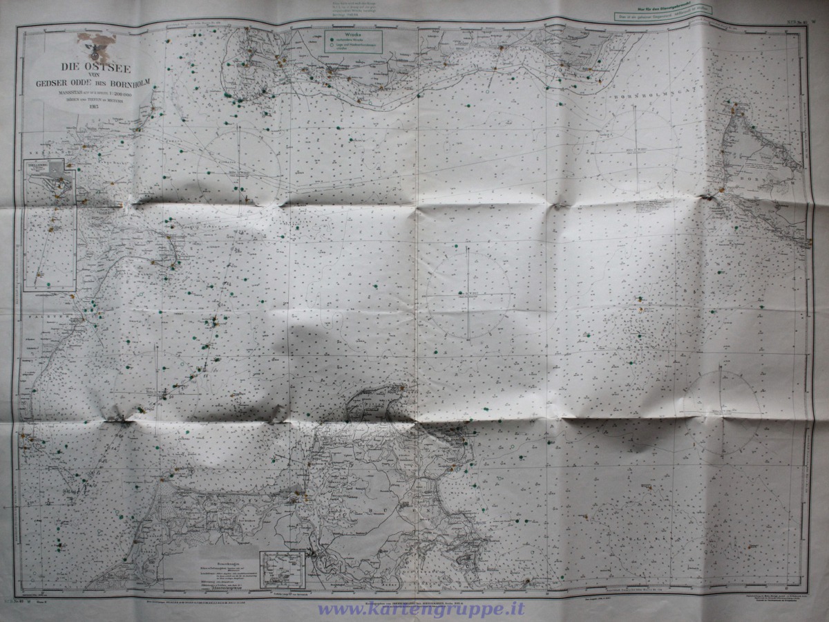 In any case it's a good built. kartengruppe Quote:
|
|
|
|
|
|
04-08-12, 08:23 AM
|
#13 |
|
Nub
 Join Date: Apr 2012
Posts: 3
Downloads: 255
Uploads: 0
|
Nice job !!
|
|
|
|
|
02-25-19, 07:58 AM
|
#14 |
|
Bilge Rat
 Join Date: Feb 2019
Posts: 1
Downloads: 0
Uploads: 0
|
Is there someone who can provide high resolution KM Maps of Greece and especially the Aegean Sea?
|
|
|
|
|
02-25-19, 10:57 AM
|
#15 |
|
Gefallen Engel U-666

 Join Date: Jul 2013
Location: On a tilted, overheated, overpopulated spinning mudball on Collision course with Andromeda Galaxy
Posts: 30,014
Downloads: 24
Uploads: 0


|
TimOllmann!

__________________
"Only two things are infinite; The Universe and human squirrelyness?!! |
|
|
|
 |
| Thread Tools | |
| Display Modes | |
|
|


 Hybrid Mode
