
|
|
SUBSIM: The Web's #1 resource for all submarine & naval simulations since 1997
|
SUBSIM: The Web's #1 resource for all submarine & naval simulations since 1997 |
|
|
 06-06-10, 07:49 PM
|
#1 | |
|
Ocean Warrior
 Join Date: Apr 2005
Location: Carmel, Indiana
Posts: 3,250
Downloads: 320
Uploads: 11
|
Quote:
__________________
Irish1958 
|
|

|

|
|
06-07-10, 07:57 AM
|
#2 |
|
Mate
 Join Date: Dec 2008
Posts: 52
Downloads: 41
Uploads: 0
|
I have read it. Very cool solution, thank you a lot for the effort !
|
|
|
|
|
06-07-10, 11:10 AM
|
#3 |
|
Eternal Patrol

 Join Date: Nov 2002
Location: High in the mountains of Utah
Posts: 50,369
Downloads: 745
Uploads: 249


|
Very nice!

__________________
Never do anything you can't take back. Rocky Russo |
|
|
|
|
06-07-10, 04:10 PM
|
#4 |
|
Ocean Warrior
Join Date: Apr 2005
Location: Carmel, Indiana
Posts: 3,250
Downloads: 320
Uploads: 11
|
Kuikueg,
Excellent paper  Thanks for your effort. And welcome aboard to Subsim. I hope you enjoy this group of people. "Keep up the good work."
__________________
Irish1958
|
|
|
|
|
09-22-11, 11:15 PM
|
#5 |
|
中国水兵
 Join Date: Dec 2010
Posts: 278
Downloads: 91
Uploads: 0
|
Question was: in medium fog at which location is a warship at 06:07hour?
All the same input-data, but with 3 different results: (1)U-52-Hydrophone guy: distance: 3km - 25km at 280° relative bearing course: unknown speed: 7kn - 14 kn (2)U-52-Navigator with u-boat-map-tools: distance unknown at 280° relative bearing course: 087°T speed: unknown (1)+(2) 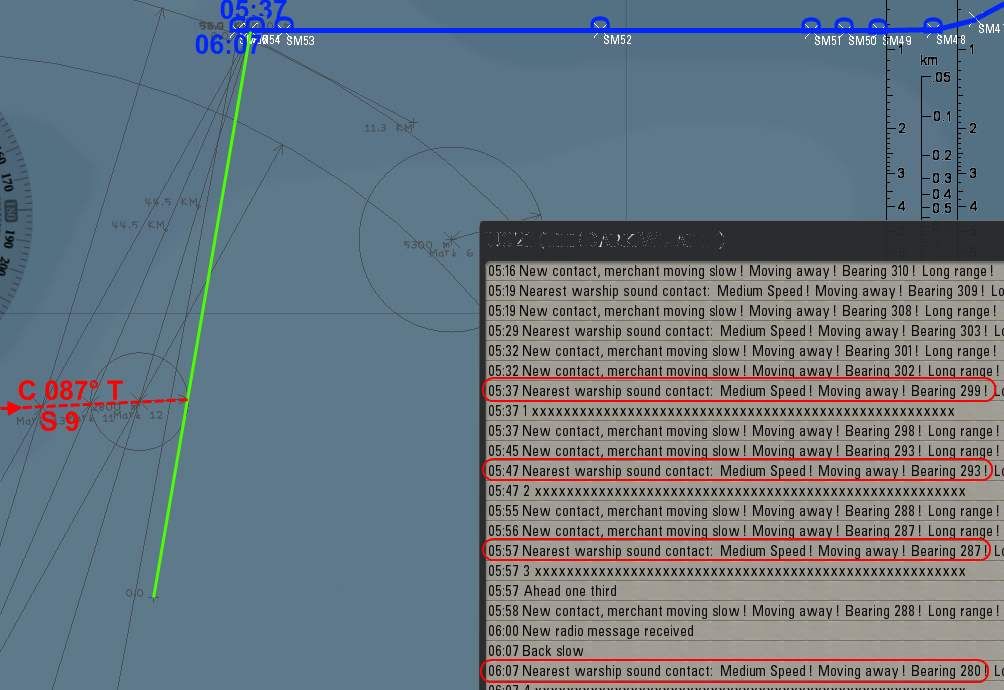 (3)GeoGebra: distance: 41 km at 280° relative bearing course: 114° T speed: 13.0 kn 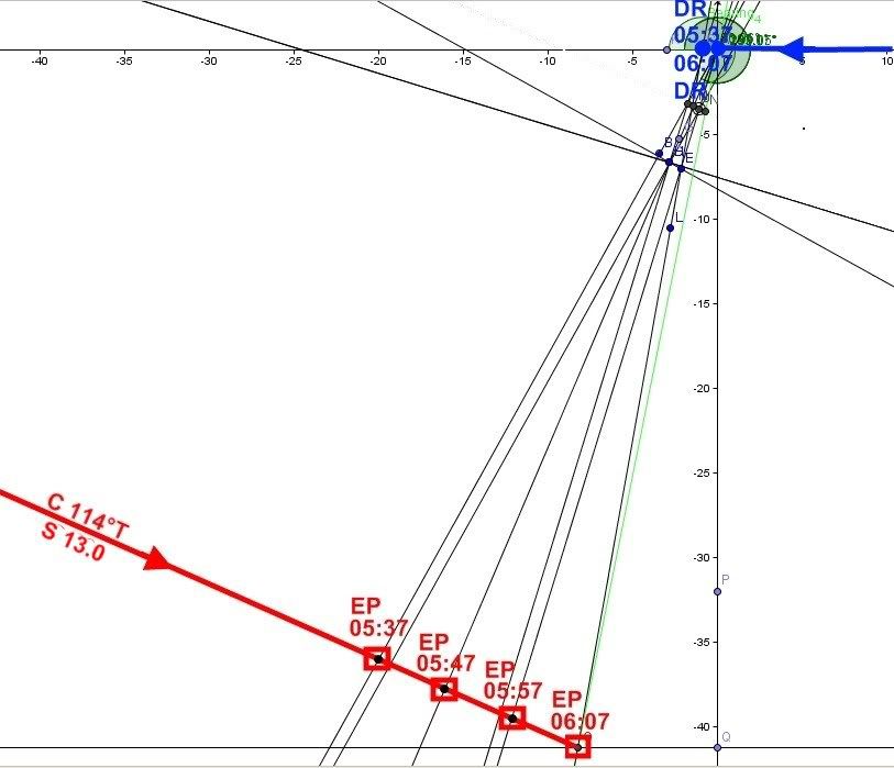 And the worst thing is: all 3 results are wrong or not precise enough. - Problem bearingcalls by hydrophone-guy Vs. true bearing: http://www.subsim.com/radioroom/show...6&postcount=13 Last edited by ETsd4; 11-24-11 at 02:10 PM. |
|
|
|
|
10-25-11, 05:51 PM
|
#6 |
|
Bosun
 Join Date: Feb 2011
Posts: 66
Downloads: 95
Uploads: 0
|
Anyone have the math involved for the solution wAs thinking about making a calc program to solve the problem for fun.
|
|
|
|
|
10-25-11, 10:09 PM
|
#7 | |
|
中国水兵
Join Date: Dec 2010
Posts: 278
Downloads: 91
Uploads: 0
|
Quote:
|
|
|
|
|
|
02-10-13, 09:54 AM
|
#8 |
|
Seasoned Skipper
 Join Date: Mar 2008
Posts: 698
Downloads: 262
Uploads: 0
|
I hope its ok to be posting in such an old thread but I have a question regarding using the hydro to plot a convoy's course. If visibility conditions are no good (i.e. fog or night) and you are playing "no map contacts" how do you plot a convoy's course and speed?
I have become proficient at the 4 bearings method on full realism for single contacts. What I'm having a tough time with is using this method to track and plot a convoy course, speed, range. There are too many sound contacts to be able to take a bearing off a single target for all four bearings. It gets confusing and teh hydro guy starts picking up new targets and as escorts are doing their search patterns the "closest sound contact" is constantly changing making the use of the "4 bearings method" almost impossible. What are other people's strategies for plotting a course of a convoy using the hydro (no map contacts)? Thanks.
__________________
|
|
|
|
 |
| Tags |
| bearing, tracking |
| Thread Tools | |
| Display Modes | |
|
|


 Hybrid Mode
