
|
|
SUBSIM: The Web's #1 resource for all submarine & naval simulations since 1997
|
SUBSIM: The Web's #1 resource for all submarine & naval simulations since 1997 |
 06-27-13, 08:23 PM
|
#1 |
|
Soundman
 Join Date: Nov 2012
Posts: 146
Downloads: 60
Uploads: 2
|
This is the first in a series on Coastal / Terrestrial Navigation, sometimes referred to as Piloting or Pilotage.
Warning: Long Post! How to do Running Fixes (or Versegelungspeilung) aka "Transferred Position Line" Also applicable to SH4 and SH5, method is the same... For those doing manual navigation, but are currently only doing dead reckoning plots, this may be of interest to you as something to add into the nav mix. There's probably plenty of you that do this already so apologies if I'm stating the obvious. This tutorial assumes you're already doing dead reckoning navigation at least (i.e. not using SH3 waypoints). If anything is unclear (it will be I'm sure) then please ask and I'll do my best to answer. Apologies that my images are a bit of a mess, if anyone wants a video tutorial for this, I'll make sure it's all neater and clearer. The Important Stuff Keep real pencil and paper notes! (obvious for manual navigating veterans) These fixes are only useful when land is within sight (and impossible when it's not), and ideally slightly more in sight than a "blur in a fog bank" that you'll get at around 9 maybe 10km away. When plotting any fixes that rely on visual aids, you need to bear the following in mind. SH3 maps don't mark landmarks like lighthouses, or buoys that real nav charts do, the first step is to find a clearly identifiable bit of land. Warning: this is more difficult than it sounds. Double check that what you're looking it is what you think it is. Inlets or islets are really good for this. Any point where there is a sudden shift in pixels... The pixelated nature of the landscape in SH3 works in our favour here as it means you can identify a corner or edge to consistently take measurements from. Plotting a Running Fix Obviously you need to have the sub icon removed from the nav map, which if you're already doing manual navigation you will have done already. (If not, shameless plug for my mini mod) 1. Draw your course line Your plotted course. Use the protractor to mark this from your known starting position. Tell you steuermann to get on it by giving him the relevant heading to follow. Make a note of your speed and keep it as cosistent as possible. (Again, obvious stuff). My example: A course of 337 so Helgoland passed on my port side, speed = 8kts. (Normally I'd note distance and ETA of the leg, but not important for this example) 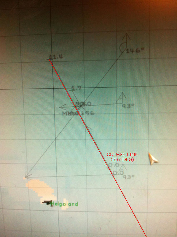 2. Pick your landmark and take a bearing (#1) Using periscope or UZO take a reading of the bearing of landmark of choice, (make sure it's still likely to be in range for second reading later...) and convert into True Bearing. Maths that may be obvious for some, but sharing to be helpful if not:-
Plot the bearing line onto navigation map using the protactor, so that it ends on the landmark you observed and crosses/bisects your course line. Where these lines cross is roughly where you boat is, but with only one "Line of Position" it's very rough. Any navigational fix requires at least two LOPs, so we carry on... My example: I took a bearing of the Helgoland north islet (Lange Anna?) of 267 (true bearing) at 1335. I marked this in SH3 by using the protractor to draw this angle so that it bisected my course line. 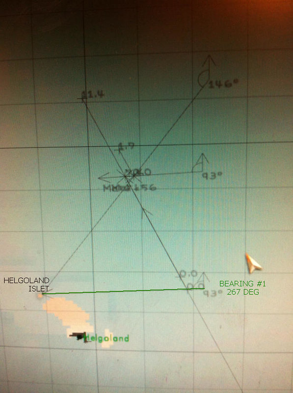 Note: It's much easier to draw the line from the observed point rather than to it.... But this means the angle labels become overlaid and obscured, but as long as you've written them down on paper, it doesn't matter. 3. Steam ahead for a bit then take a second bearing... (#2) I generally use intervals of 30 minutes (game time) between readings. So skip ahead 30 minutes and take a second bearing of the same spot. Plot this on the SH3 navigation map in the same way as in Step 2. My example: I took a bearing of 214 (true) at 1405 (making sure the UZO line up with the exact same edge/corner as previously) 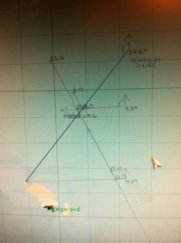 4. Work out distance travelled As you have noted your speed, you will know how far you should have travelled. Consulting the speed chart you can see that 8 knots is 14.82km/h - so in 30 minutes we should have travelled 7.41 km (round down to 7.4). Mark this exactly over the course line with the ruler, starting from the point where the first bearing line crosses the course line. The cross end of this ruler point is important, make sure it lines up over the course line as exact as possible. 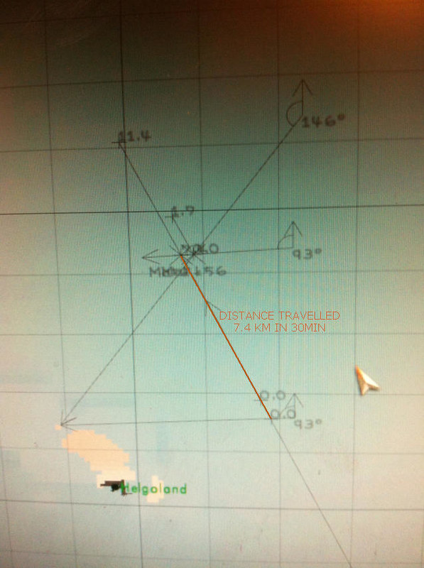 5. Transfer the first bearing line This is where it gets tricky. Using the protactor, you will need to redraw the first bearing angle so that it bisects the end of the ruler mark that you just made, and the second bearing line. This may take a few attempts (it took me a good 4 or 5 minutes the first time). If someone can mod a copy and paste function for map marks, it would be hugely appreciated (with a Parallel Rule icon :P) 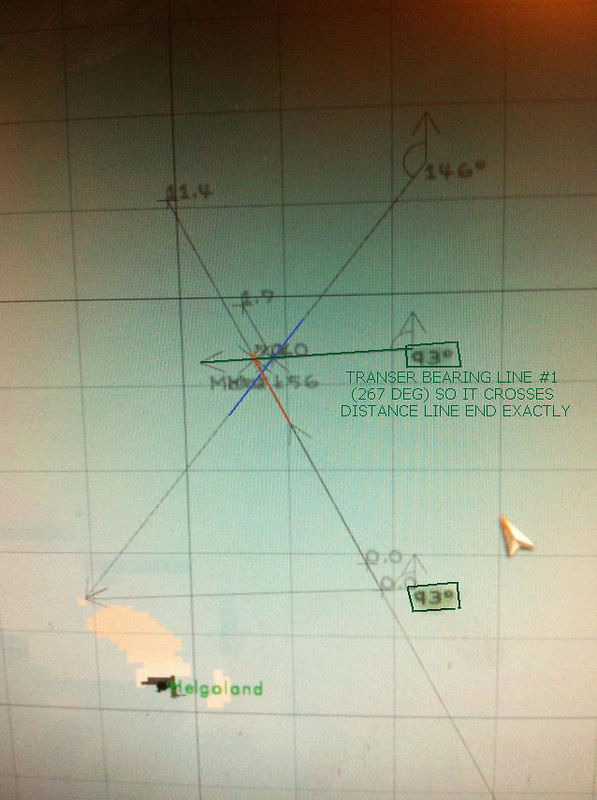 Where this new transferred first bearing line crosses over the second bearing line is the approximate position of your boat at the time you took the second bearing. Well done. If my waffle made any sense, you can now do Running Fixes. 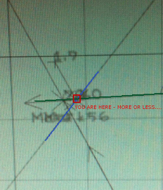 Note: There is an extra Dead Reckoning line on my screenshot as it took me a couple of minutes to transfer the line (and failing to get screenshots to work properly), so I had to compensate for that time when confirming my actual position (cheating :P). 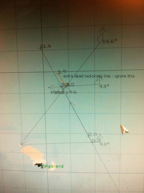 ~-~-~-~-~-~-~-~ Margin of error with this method, for me at least, is usually 200 metres (in calm waters), which is pretty decent. This type of fix will only ever be approximate. What I refer to as bearing lines should properly be called Lines of Position, or LOPs. The next step for is to make printable versions of the SH3 map so that I can do this with a parallel rule and pencil etc. Should be quicker than faffing about on the nav map in game. And more fun. I'm sure the old hands Next Time on Heinrich's Half Hour (well done if you got through that wall of text)
__________________
Die Südfrüchte runter vom Kartentisch. Auf Bananen kann ich nicht navigieren. Last edited by Karl Heinrich; 07-04-13 at 08:40 PM. |

|

|
| Tags |
| navigation, plotting, real navigation, running fix, running fixes |
|
|


 Threaded Mode