
|
|
SUBSIM: The Web's #1 resource for all submarine & naval simulations since 1997
|
SUBSIM: The Web's #1 resource for all submarine & naval simulations since 1997 |
 06-22-07, 10:06 AM
|
#1 |
|
Navy Seal
 Join Date: Mar 2007
Location: New Mexico, USA
Posts: 9,023
Downloads: 8
Uploads: 2
|
Doesn't work.
I checked it last night. It's cool that ships are sunk below the horizon, but I tested last night vs this on a lark: 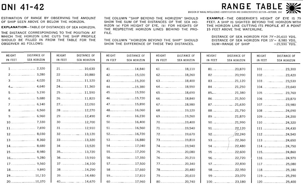 Using the profile of Kongo in ONI 41-42 I. No dice. I set up a mission at ~10 nm range, 90 degree AOB. Interestingly, my first guess (assuming a height above sea level on a Porpoise of 30 feet (looking at crew vs waterline)) showed around 20,000 yards! Looked good. I got closer, and the map contacts showed Kongo at ~5.3nm. The horizon cut Kongo about the same though. Too bad, it'd make no contact reports so much cooler if you could get the range. I guess it might be possible to make a similar table for SH4's world geometry... |

|

|
|
06-22-07, 11:25 AM
|
#2 |
|
Planesman
 Join Date: May 2007
Location: San Francisco, California
Posts: 185
Downloads: 1
Uploads: 0
|
This is exactly what I was looking for in my other thread about not being able to measure distances to far-away targets using the stadimeter. Too bad it's not modeled properly to work in the game.
You say the horizon 'cut' the Kongo at about the same point even when you got closer to it? That would seem to indicate that they're just kinda 'faking' the horizon curve rather than modeling it... which would mean that we wouldn't be able to create our own table based on SH4 world geometry. nomad_delta |
|
|
|
|
06-22-07, 11:33 AM
|
#3 |
|
Navy Seal
Join Date: Mar 2007
Location: New Mexico, USA
Posts: 9,023
Downloads: 8
Uploads: 2
|
It's odd. At long ranges, the ships certainly sink the horizon. Once it's in "real" visual range, perhaps the horizon is abandoned some how...
My hope is that it might work when we see masts over the horizon. |
|
|
|
|
06-22-07, 03:06 PM
|
#4 |
|
Pacific Aces Dev Team

 Join Date: Sep 2002
Location: Spain
Posts: 6,109
Downloads: 109
Uploads: 2

|
Hang on, this has a possible solution....messing with earth radius value in the scene.dat file changes the curvature of the earth and as such the level of ship over the horizon....it's a matter of trial and error until getting it right. Though I'm not willing to give it a go until 1.3 is here and we see the definitive form of SH4 :hmm:
__________________
One day I will return to sea ... |
|
|
|
|
06-22-07, 03:12 PM
|
#5 |
|
Navy Seal
Join Date: Mar 2007
Location: New Mexico, USA
Posts: 9,023
Downloads: 8
Uploads: 2
|
Cool, I have all the ONI manuals, too. As they are public domain documents, they can be converted to whatever we like.
I had this wierd idea that you could make a new recognition manual entry (like a country) where eacy "ship" is just a number, and the number is a height. Look at a manual, decide what landmark you like, select the height you guess it is, use the stadimeter... |
|
|
|
 |
|
|


 Linear Mode

