
|
|
SUBSIM: The Web's #1 resource for all submarine & naval simulations since 1997
|
SUBSIM: The Web's #1 resource for all submarine & naval simulations since 1997 |
 12-20-16, 05:00 PM
|
#61 | |
|
Sonar Guy
 Join Date: Oct 2009
Location: Sofia, Bg
Posts: 384
Downloads: 264
Uploads: 1

|
Quote:
The long task in SH3 for me are the forests files. The forest file is responsible for distribution of the trees on the terrain. It's a .dat file with many placement nodes, where you call specific tree and give it coordinates. And one forest file may contain hundreds or thousands of placement, so it's tedious, I don't do it every day.
__________________
If you ride like lightning, you're gonna crash like thunder. |
|

|

|
|
12-20-16, 06:59 PM
|
#62 | |
|
A-ganger
 Join Date: May 2009
Posts: 76
Downloads: 281
Uploads: 0
|
Quote:
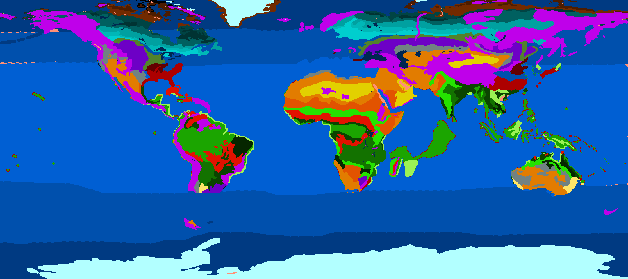
 it is a Colossal work that you have undertaken. I even wonder if it's reasonable? Why give so much importance to the placement of these trees? it is a Colossal work that you have undertaken. I even wonder if it's reasonable? Why give so much importance to the placement of these trees?Here is the reference that I wish to use to modify the map "TerrainTypes" of the climatic regions. This is the "köppen climate classification" https://learn.weatherstem.com/module...ons/88/12.html https://en.wikipedia.org/wiki/K%C3%B...classification I think it is possible to create more than 20 climatic regions with their unique vegetation. What do you think? Last edited by astradeus; 12-20-16 at 11:02 PM. |
|
|
|
|
|
12-21-16, 11:10 AM
|
#63 |
|
Stowaway
Posts: n/a
Downloads:
Uploads:
|
1. Would it be possible to have the same placement for the trees during summer and winter ? Because if (for example) you place correctly a bunker in summer, sometimes in winter there are trees just on it, and it's so bad looking !
 2. What is that ? : |
|
|
|
12-21-16, 02:03 PM
|
#64 |
|
A-ganger
Join Date: May 2009
Posts: 76
Downloads: 281
Uploads: 0
|
2. What is that ?
I am not very sure, but I think it represents an area of vegetation. Unless otherwise stated, each yellow dot represents a tree. The goal is to organize this set of points so that they are more natural or more concentrated or more. |
|
|
|
|
12-27-16, 02:20 PM
|
#65 | |||
|
Sonar Guy
Join Date: Oct 2009
Location: Sofia, Bg
Posts: 384
Downloads: 264
Uploads: 1
|
Quote:
But for various reasons, I'm not in the mood for that, so that will extend to several months. Quote:
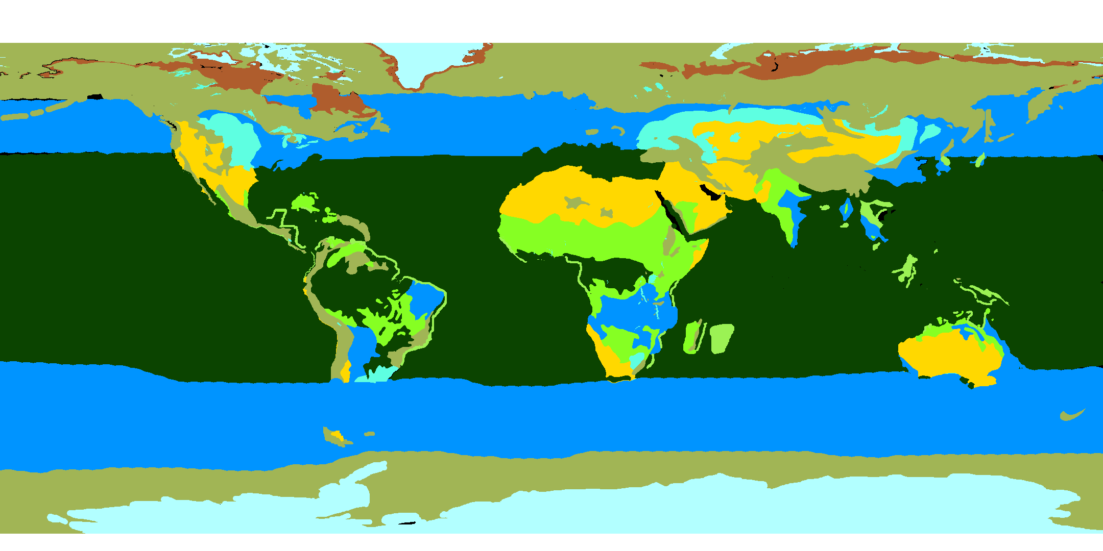
Will use Fahnenbohn screens from the second page of this topic: Then is simplified through Terrain.cfg to 9 terrain types. So, even only with editings to [IdxConversion] is possible to make more terrain type of some regions. But, I decided to make my own. My approach is to do it simple, only 12 shades. First shade cover the whole world, I call it generic. Then over it I draw, not too deep in land, next 11 shades. There is no point, to draw something in the middle of the continents. And my terrain types are these: Code:
[IdxConversion]
IDX 1=0;	/ Generic	/ 1 season
IDX 2=1; / Ice	/ 1 season
IDX 3=2; / Tundra	/ 2 seasons (winter, summer)
IDX 4=3; / Taiga	/ 2 seasons (winter, summer)
IDX 5=4; / Temperate North	/ 4 seasons (winter, spring, summer, autumn)
IDX 6=5; / Temperate South	/ 4 seasons (summer, autumn, winter, spring)
IDX 7=6; / Chaparral	/ 2 seasons (winter, summer)
IDX 8=7; / Desert	/ 1 season
IDX 9=8; / Jungle	/ 1 season
IDX 10=9; / Savanna	/ 2 seasons (dry, wet)
IDX 11=10; / Grassland North	/ 2 seasons (dry, wet)
IDX 12=11; / Grassland South	/ 2 seasons (dry, wet)
Quote:
How is it in the original files, I did not checked. My way to make the forest file, will describe soon.
__________________
If you ride like lightning, you're gonna crash like thunder. Last edited by Tycho; 12-27-16 at 02:28 PM. |
|||
|
|
|
|
12-27-16, 02:27 PM
|
#66 |
|
Sonar Guy
Join Date: Oct 2009
Location: Sofia, Bg
Posts: 384
Downloads: 264
Uploads: 1
|
Editings of this post: How the terrain texturing work.
I changed and added something important about Tex04.
__________________
If you ride like lightning, you're gonna crash like thunder. |
|
|
|
|
12-28-16, 09:39 AM
|
#67 | |
|
A-ganger
Join Date: May 2009
Posts: 76
Downloads: 281
Uploads: 0
|
thank you for your answers .
No answer, I thought you were gone.  I am currently testing a map that I have created and that seems operational. It contains 32 different types of vegetation zones. But I am not yet satisfied with the accuracy of the actual data. This is my trial version. I chose to make big, because even if all zones are not exploited immediately, it is possible to associate several [IdxConversion] with the same type of vegetation. For example: IDX 1 = 6; Tropical / rainforest IDX 2 = 6; Tropical / rainforest IDX 3 = 6; Tropical / rainforest  Quote:
In my experimentation for sh5, I am looking for a way to get a better rendering of the textures in the game. I thought to modify the models "vegetation.GR2" Or use the normal map textures for trees. What are you going to do? Last edited by astradeus; 12-28-16 at 09:47 AM. |
|
|
|
|
|
01-15-17, 03:37 AM
|
#68 |
|
Commander
 Join Date: Aug 2007
Location: Italia Venezia
Posts: 465
Downloads: 228
Uploads: 0
|
OOPSS!!!!!

|
|
|
|
|
01-16-17, 01:37 AM
|
#69 |
|
Stowaway
Posts: n/a
Downloads:
Uploads:
|
what's going on here ?
|
|
|
|
01-16-17, 01:42 AM
|
#70 | |
|
Stowaway
Posts: n/a
Downloads:
Uploads:
|
Quote:
 I think it would be cool to add new climates based on local climate + the altitude : firs in high altitude, and even no trees but only rocks or ice for very high altitudes. |
|
|
|
|
01-16-17, 04:37 AM
|
#71 | |
|
Commander
Join Date: Aug 2007
Location: Italia Venezia
Posts: 465
Downloads: 228
Uploads: 0
|
Quote:
But the DD shoots the torpedo only to 90 degrees (elevation) and it falls into water immediately after being shot. |
|
|
|
|
|
03-10-17, 07:01 AM
|
#72 | |
|
Stowaway
Posts: n/a
Downloads:
Uploads:
|
Quote:
|
|
|
|
|
04-12-17, 11:18 AM
|
#73 |
|
Sonar Guy
Join Date: Oct 2009
Location: Sofia, Bg
Posts: 384
Downloads: 264
Uploads: 1
|
Now I saw that last time when I work on my terrain and forest files is end of january.
Will finish this probably when the autumn come. But now I have something new. Very interesting. But I'm on vacantion now, when get home will show and give you. Until then, I'll let you guess.
__________________
If you ride like lightning, you're gonna crash like thunder. |
|
|
|
|
04-12-17, 11:54 AM
|
#74 | |
|
Stowaway
Posts: n/a
Downloads:
Uploads:
|
Quote:
|
|
|
|
|
04-12-17, 02:15 PM
|
#75 | |
|
Sonar Guy
Join Date: Oct 2009
Location: Sofia, Bg
Posts: 384
Downloads: 264
Uploads: 1
|
Quote:
__________________
If you ride like lightning, you're gonna crash like thunder. |
|
|
|
|
 |
|
|


 Linear Mode

