
|
|
SUBSIM: The Web's #1 resource for all submarine & naval simulations since 1997
|
SUBSIM: The Web's #1 resource for all submarine & naval simulations since 1997 |
 12-26-10, 01:10 PM
|
#1 |
|
Ace of the Deep
 Join Date: Oct 2006
Posts: 1,151
Downloads: 152
Uploads: 0

|
Quite a while ago someone asked for KriegsMarine maps and I uploaded my collection and published the link.
Now - deeply surprised by the number of downloads - I've cleaned the map collection up a bit. Many of the KM Maps were found in PDF-format, these have now been converted to jpeg-files instead. In this MediaFire folder you'll find the following files: KM_Maps_JPG_I - content 21 maps (183MB) KM_Maps_JPG_II - content 12 maps (194MB) Sea_Maps_historic - content 63 maps (8.5MB) WW2_NG_Maps - content 22 maps *) (3.3MB) Note that the KM maps are full sized. If you have access to a plotter, you can have these printed in their original sizes, like 2x2 meters or more... *) The National Geographics maps are poorly photographed copies and are solely uploaded to show the amount of map knowledge and details used "back then" and I can only encourage you to do a search for National Geographics Magazines to buy the original magazines or buy the NGM collection on http://ngm.nationalgeographic.com/ |

|

|
|
12-26-10, 02:15 PM
|
#2 |
|
Commander
 Join Date: Jul 2010
Location: Spain
Posts: 455
Downloads: 87
Uploads: 0
|
Thx mate

|
|
|
|
|
12-27-10, 06:52 AM
|
#3 |
|
Chief
 Join Date: Feb 2010
Posts: 327
Downloads: 30
Uploads: 0
|
Great!
Thank you. EDIT/ Excellent quality! I will try them next time i am out. PS Maps can be made with SeaClear II, free download, non copyright protected Last edited by Matador.es; 12-27-10 at 10:07 AM. Reason: EDIT |
|
|
|
|
12-27-10, 10:12 AM
|
#4 |
|
Seasoned Skipper
 Join Date: Mar 2010
Location: Berlin, Germany
Posts: 718
Downloads: 575
Uploads: 0
|
Dankeschön!
Echol  t. t.
|
|
|
|
|
12-27-10, 09:34 PM
|
#5 | |
|
Ace of the Deep
Join Date: Oct 2006
Posts: 1,151
Downloads: 152
Uploads: 0
|
Quote:
A great and very interesting little program. Thanks a lot!  Would probably raise a few eyebrows in the harbour, seing you're using some old Kriegsmarine Karts for tripplanning...  The SeaClear program recommends using BMP or TIFF files, so I did a few tests... This KM No. 3270 English Channel, dimensions 208x266 cm  In jpeg the map weighs 28 MB (not suited for use in SeaClear- blurred image when zoomed in) In BMP it grows to 148 MB (much better sharpness) And in TIFF it is a whopping 293 MB  If needed by anyone, I wouldn't mind doing the conversions into BMP, PNG or TIFF, which btw. clearly is the sharpest format. Certainly not suited for an upload, but instead I can ship a DVD with maps in requested format(s). This service will require a donation to Subsim, though. Thanks again for the SeaClear reference. Most appreciated! |
|
|
|
|
|
12-29-10, 05:29 AM
|
#6 |
|
Chief
Join Date: Feb 2010
Posts: 327
Downloads: 30
Uploads: 0
|
You are welcome.
|
|
|
|
|
03-22-11, 11:17 PM
|
#7 |
|
Ace of the Deep
Join Date: Oct 2006
Posts: 1,151
Downloads: 152
Uploads: 0
|
Sorry for this little bump, but with nearly a thousand downloads
Since MediaFire limits filesize for free accounts to 200MB, I had to split the reworked JPEGs into two downloads, KM_Maps_JPG_I and KM_Maps_JPG_II. However there are nearly twice as many downloads for part I than part II... so here's an index of the two downloads: KM_Maps_JPG_I: Low-res B/W maps: Atlantic, Central and South Atlantic, North Atlantic, West Baltic Sea Black Sea England World Map Grid Mediteranean Sea Northern Theatre Pacific Ocean Siberian Sea Route Hi-res org. colored maps: Grid Overlay Sheet Grid Sheet KM No 1851G Ostsee (Baltic) KM No 1859 skagerak KM No 1870 North Atlantic Ocean KM No 1889G London KM No 1902 Denmark KM No 1931G Mozambique and Madagascar KM No 3100 Ostsee (Baltic) North Half Direct link to package KM_Maps_JPG_I: http://www.mediafire.com/?udnqyp30p3bdar4 KM_Maps_JPG_II: Hi-res org. colored maps: KM No 3100 Ostsee (Baltic) Southern Half KM No 3270 English Channel KM No 3401 Atlantic Grid KM No 3451 NewFoundland KM No 3465 North Polar Sea KM No 3486 Amazon KM No 3497 Long Island to Cape Canaveral KM No 3531 Kongo KM No 3735 Baluchistan North Half KM No 3735 Baluchistan South Half KM Norway North 1945 KM Norway South 1945 Direct link to package KM_Maps_JPG_II: http://www.mediafire.com/?mhm9x0oh7v8h11n Hope this clears things up a bit and that those, who "only" downloaded package I, may get their collection more complete. Speaking of complete... haven't been able to track anymore maps, so if you know of any, please share!
|
|
|
|
|
04-05-11, 05:24 PM
|
#8 |
|
Loader
 Join Date: Apr 2010
Location: Italy
Posts: 85
Downloads: 17
Uploads: 0
|
hallo
if you like it, here (follow the link www.kartengruppe.it) you may find my collection of Kriegmarine maps: I have about 100 original WW2 charts. See them! Kartengruppe ... and this is for you!! ;-D 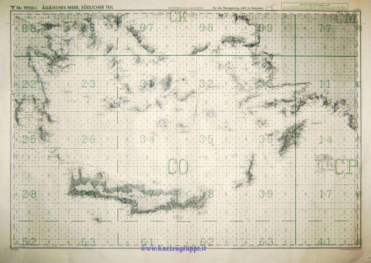
|
|
|
|
|
04-06-11, 11:04 AM
|
#9 |
|
中国水兵
 Join Date: Dec 2010
Posts: 278
Downloads: 91
Uploads: 0
|
@Kartengruppe: The maps are absolute fantastic.
Is there a possiblity we can have access to these maps in full resolution? 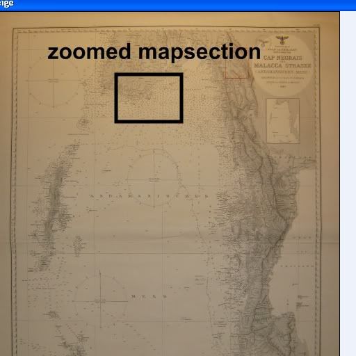 Zoomed mapsection: 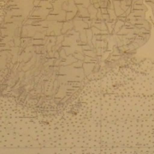
|
|
|
|
|
04-06-11, 02:24 PM
|
#10 |
|
Loader
Join Date: Apr 2010
Location: Italy
Posts: 85
Downloads: 17
Uploads: 0
|
Hi, thanks for the interest
The maps are so big for high resolution photo. I have scanned some of them for a personal use but it's so expensive and it can wrap them. ... but I think in the next days I'll add some for all the users Nice to meet you Pino |
|
|
|
|
04-06-11, 03:39 PM
|
#11 | |
|
中国水兵
Join Date: Dec 2010
Posts: 278
Downloads: 91
Uploads: 0
|
Quote:
I mean i ask for to pick up a cheap 5MB-resolution camera and make some close-ups of the map, so we have lets say 15 photoshots for each map. A compilaton of these 15 pictures to one huge picture is not necessary. IMO details is that what counts. If we have maps but cannot read the water depth, cannot identify light-house positions and cannot identify the coastline (mountains etc.) then these maps are just decoration and useless. |
|
|
|
|
|
04-07-11, 09:28 AM
|
#12 | |
|
Loader
Join Date: Apr 2010
Location: Italy
Posts: 85
Downloads: 17
Uploads: 0
|
Quote:
I made so much ... I have a scan of the map so I have uploaded an high resolution pdf file I just added a little transparent watermark You may find it on: http://www.mediafire.com/?vfd9008hu2jccsl It's compressed on 20Mb jpg format (as the original .tif was about 200 mb). The file is about 8100*6100 pixel, 200 dpi! For your funny Pino PS: For all the users, please visit my site http://www.kartengruppe.it |
|
|
|
|
|
04-07-11, 10:17 AM
|
#13 |
|
Sea Lord
Join Date: Mar 2010
Posts: 1,845
Downloads: 184
Uploads: 2
|
Speaking about maps.. does anyone know a mine map used in ww2? I know where mines were used in north sea, but where else?
|
|
|
|
|
04-07-11, 03:24 PM
|
#14 | ||
|
Ace of the Deep
Join Date: Oct 2006
Posts: 1,151
Downloads: 152
Uploads: 0
|
Quote:
 Of course we now expect all your maps uploaded like that!  Quote:
|
||
|
|
|
|
04-07-11, 05:22 PM
|
#15 | |
|
中国水兵
Join Date: Dec 2010
Posts: 278
Downloads: 91
Uploads: 0
|
Quote:
I am also interested in some books, for example this one, the nautic almanac from 1938 => "Nautisches Jahrbuch oder Ephemeriden und Tafeln für das Jahr 1938 zur Bestimmung der Zeit, Länge und Breite zur See nach astronomischen Beobachtungen. Siebenundachtzigster Jahrgang, in ottavoNote: Berlin Carl Heymanns 1937" |
|
|
|
|
 |
|
|


 Linear Mode

