
|
|
SUBSIM: The Web's #1 resource for all submarine & naval simulations since 1997
|
SUBSIM: The Web's #1 resource for all submarine & naval simulations since 1997 |
 04-22-08, 04:45 PM
|
#61 |
|
Torpedoman
 Join Date: Mar 2007
Location: Virginia (USA)
Posts: 113
Downloads: 7
Uploads: 0
|
I'm guessing it's a weakness of the engine/terrain editor that makes the shoreline of the canals sawtoothed?
-m |

|

|
|
04-22-08, 05:47 PM
|
#62 | |
|
Grey Wolf
 Join Date: Nov 2005
Location: Mar del Plata, Argentina
Posts: 871
Downloads: 0
Uploads: 0
|
Quote:
Ref
__________________

|
|
|
|
|
|
04-22-08, 06:02 PM
|
#63 |
|
Mr. Bad Wolf

Join Date: Aug 2005
Location: Aabenraa, Denmark
Posts: 1,488
Downloads: 47
Uploads: 0
|
@ref
Thank you, have read your tutorial and played a bit. It seems okay to handle.  I hope it's okay that I edited your fake locks of the panama canal out ? Hoping to see the canals from Trainer1942 soon to put in their place. @aanker and akdavis Thanks for the info about Truk  If not anyone else is up for it (having a secret desire which almost burns up their heart), I would like to try add the corals around Truk after having compared with Google maps. Though Truk is mostly on one RAW file, a little part of it is more or less extended to three opposing RAWs. Will try to play around with it, and if it's okay, I may call for help...
__________________
  Download my mods from SHMF Follow my photography here taler dansk, speak English, spreche Deutsch, parle français, forstår svenska/norsk, comprendo castellano |
|
|
|
|
04-22-08, 06:23 PM
|
#64 | |
|
Pacific Thunder

 Join Date: Apr 2004
Location: Yellow Sea
Posts: 1,896
Downloads: 236
Uploads: 14

|
Quote:
Thank you ref !! ... Thank you ALL Art |
|
|
|
|
|
04-22-08, 06:44 PM
|
#65 | |
|
Mr. Bad Wolf
Join Date: Aug 2005
Location: Aabenraa, Denmark
Posts: 1,488
Downloads: 47
Uploads: 0
|
Quote:
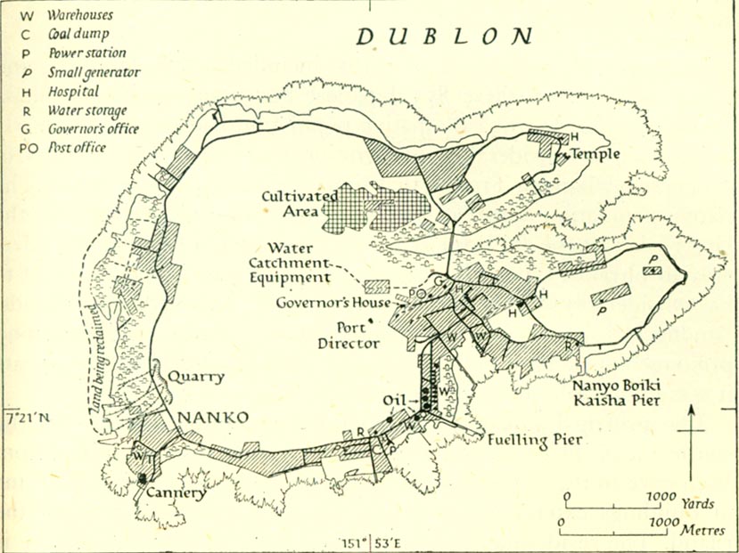
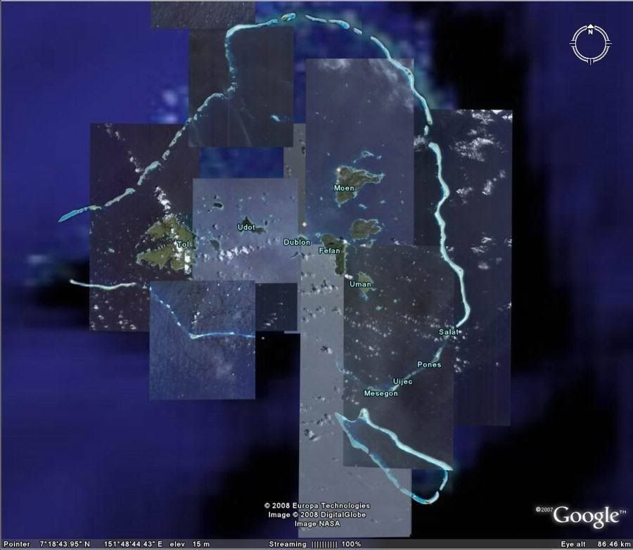 It seems using Google maps and regarding the info in this thread that Dublon and especially Moen should be given harbour and city facilities: West-side of Dublon? 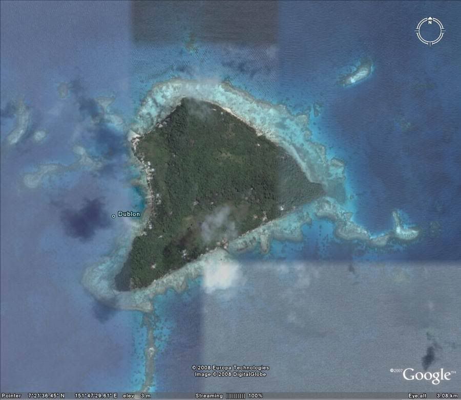 North-East side of Moen? 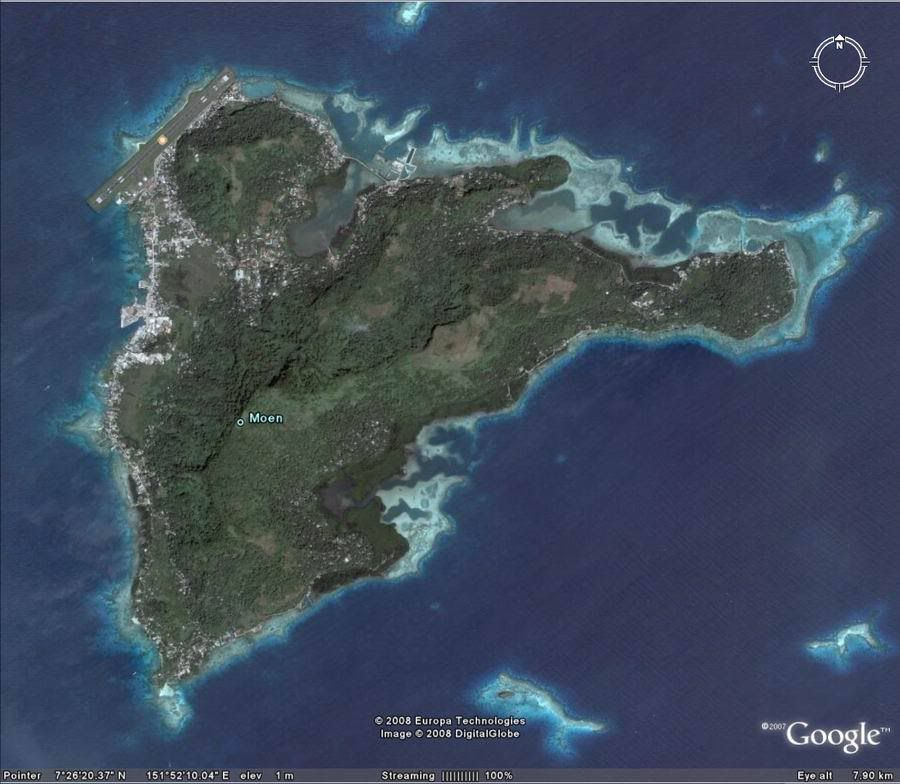 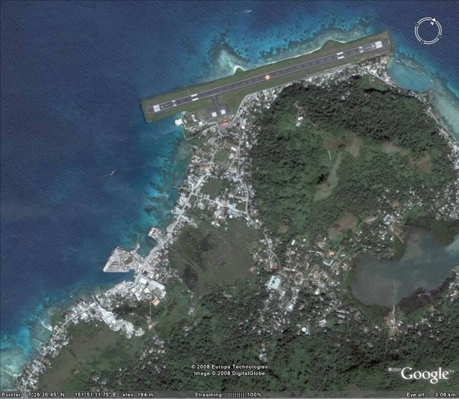
__________________
Download my mods from SHMF Follow my photography here taler dansk, speak English, spreche Deutsch, parle français, forstår svenska/norsk, comprendo castellano |
|
|
|
|
|
04-22-08, 09:06 PM
|
#66 | |||||
|
Samurai Navy
 Join Date: Mar 2005
Location: Fort Worth, Texas
Posts: 597
Downloads: 0
Uploads: 0
|
Quote:
 Quote:
 Quote:
I don't believe Moen (Weno) was as heavily developed then as it is today. It underwent development by the U.S. after the war. Pacificwrecks.com describes gives the following description: Quote:
__________________
-AKD |
|||||
|
|
|
|
04-22-08, 10:00 PM
|
#67 | ||
|
Torpedoman
Join Date: Mar 2007
Location: Virginia (USA)
Posts: 113
Downloads: 7
Uploads: 0
|
Quote:
-m |
||
|
|
|
|
04-23-08, 11:28 AM
|
#68 | |
|
Pacific Thunder
Join Date: Apr 2004
Location: Yellow Sea
Posts: 1,896
Downloads: 236
Uploads: 14
|
Quote:
Whish I had Photoshop for this editor. Art |
|
|
|
|
|
04-23-08, 12:06 PM
|
#69 |
|
Grey Wolf
Join Date: Nov 2005
Location: Mar del Plata, Argentina
Posts: 871
Downloads: 0
Uploads: 0
|
I think most image editors have the same functionality as PS, as what I used is standard features, what I ment was that I don't know the procedure on other editors, not that they aren't capable of performing the same tasks, you'll just have to experiment a bit to get the wanted results.
Ref
__________________
|
|
|
|
|
04-23-08, 12:17 PM
|
#70 | |
|
Pacific Thunder
Join Date: Apr 2004
Location: Yellow Sea
Posts: 1,896
Downloads: 236
Uploads: 14
|
Quote:
I was reading the development of your SH3 map tool: http://www.subsim.com/radioroom/showthread.php?t=89658 ... Great read Well - I'm off to play with this and Thank You again Sir! Art |
|
|
|
|
|
04-23-08, 12:38 PM
|
#71 |
|
Grey Wolf
Join Date: Sep 2007
Posts: 921
Downloads: 75
Uploads: 0
|
The scale of the 3d terrain is probably dependent on what digital elevation maps were used. The highest res ones are for the US. The rest of the world is fairly low res.
Otherwise you have to convert topo maps into a 3D file or a DEM that can then be converted. Ref is most likely very familiar with this, but for others, go here for more info. http://www.agu.org/eos_elec/97260e.html We used some of the available sat data (DEM or GEOTOPO) for Fighter Squadron terrain mods. The page below lists a lot of free terrain related stuff (maps, images, contours, DEMS). Free 3D terrain programs are listed at the bottom of the page. http://www.terrainmap.com/rm39.html
__________________
"There are only two types of ships- submarines...... and targets" Unknown "you wouldn't catch me on a ship that deliberately sinks itself"- comment to me from a surface sailor. System: AMD 6300 3.5 GHz | 32GB DDR3 | SATA 300 320GB HD, SATA III 1TB HD, SATA III 1.TB HD | ASUS Sonar DS sound card NVIDIA 1660 Super OC | Windows 10 |
|
|
|
|
04-26-08, 05:41 AM
|
#72 |
|
Sonar Guy
 Join Date: Dec 2007
Posts: 376
Downloads: 187
Uploads: 21
|
Thx 1000 thx 1000 thx 1000 thx 1000
Hello
 Works OK with photoshop elements 2. PS Maybe you like to put downloadlink for extractor to your first post. I found it today. (I know read all posts etc.) 1000 000 THANKS  PS This is how my St Nazaire looks now Dry Dock and all. as you can see Terrain tool is useful also in harbor. 
__________________
SH 
Last edited by Captain von Keldunk; 04-26-08 at 02:17 PM. |
|
|
|
|
04-26-08, 02:35 PM
|
#73 |
|
Rear Admiral
 Join Date: Apr 2006
Location: Swindon, England
Posts: 10,151
Downloads: 35
Uploads: 0
|
Wheres the link for th ealtered St Naz files then ?
No point everyone doing them if someone already has |
|
|
|
|
04-26-08, 04:22 PM
|
#74 |
|
Sonar Guy
Join Date: Dec 2007
Posts: 376
Downloads: 187
Uploads: 21
|
Download link is on my sign
Hello
I have now released St Nazaire in Loire river + dry dock. Started a new tread for it. Download link is on my sign
__________________
SH
|
|
|
|
|
04-26-08, 06:09 PM
|
#75 |
|
Pacific Thunder
Join Date: Apr 2004
Location: Yellow Sea
Posts: 1,896
Downloads: 236
Uploads: 14
|
I have given up with the Gimp for now unless someone comes up with a procedure.
My computer came with JASC Paint Shop Pro 8 installed and I have never touched it however much to my surprise the ZON file opened with Paint Shop Pro but I don't have a clue what I am doing. Anyone else have Paint Shop Pro? The instructions written by ref for Photoshop look easy enough to follow. Two questions if anyone knows. 1.) I could follow instructions for Paint Shop Pro if anyone wants to write some notes. Just to be clear I'm not asking ref how to do it because of the warning... lol The Panama Canal installed great in my SH4 and works as advertised. I really want to work on Truk Lagoon. What I eventually want to do is take a new command from CT, or New Orleans - the mouth of the Mississippi where the Manitowoc boats were off-loaded after coming down the river on barges - refuel at the Panama Canal and on to Pearl etc. 2.) What files turn these locations into Naval Bases where I could refuel? Next I'll probably be getting into the campaign layers....... I can see it coming. This is fun. Art |
|
|
|
 |
|
|


 Linear Mode

