
|
|
SUBSIM: The Web's #1 resource for all submarine & naval simulations since 1997
|
SUBSIM: The Web's #1 resource for all submarine & naval simulations since 1997 |
 08-29-16, 06:34 PM
|
#1 |
|
Der Einzelgänger

Join Date: Apr 2013
Location: Cairns, Australia
Posts: 583
Downloads: 363
Uploads: 3
|
 Would anyone know if there is a tool similar to this one in the screenshot, found in the user maps, somewhere available for download, except graduated for individual minutes instead of tens of minutes? Would make plotting contact reports etc more precise if one was available somewhere. One that scaled with the map would be even better! 
__________________
Best Regards....Kev*   "The finest Captain I ever crossed swords and set sail with" |

|

|
|
08-29-16, 11:50 PM
|
#2 | |
|
Count Dracula

Join Date: Aug 2012
Location: 46°13′N, 24°47′E
Posts: 1,816
Downloads: 405
Uploads: 0


|
Quote:

__________________
|
|
|
|
|
|
08-30-16, 09:32 PM
|
#3 |
|
Der Einzelgänger
Join Date: Apr 2013
Location: Cairns, Australia
Posts: 583
Downloads: 363
Uploads: 3
|
Thanks for the reply
 I've never been able to work out what that Timepiece Board actually does. I heard a whisper on the wind that a full Celestial Navigation mod may be in progress so I thought I had better start brushing up on Coastal and Celestial navigation just in case, and intend to make a start with Sjizzles nav tutorials if I can find them again. I've never been able to work out what that Timepiece Board actually does. I heard a whisper on the wind that a full Celestial Navigation mod may be in progress so I thought I had better start brushing up on Coastal and Celestial navigation just in case, and intend to make a start with Sjizzles nav tutorials if I can find them again.  Years ago I did a Celestial Navigation course at a Tech college and learned the "Marcq St Hilaire method" otherwise known as the "Intercept Method" but after not using it for three and a half decades, the knowledge has gradually faded into oblivion! Years ago I did a Celestial Navigation course at a Tech college and learned the "Marcq St Hilaire method" otherwise known as the "Intercept Method" but after not using it for three and a half decades, the knowledge has gradually faded into oblivion! Wow! logarithm and haversine tables...haven't heard of or seen these in over half a lifetime.... https://en.wikipedia.org/wiki/Intercept_method
__________________
Best Regards....Kev* "The finest Captain I ever crossed swords and set sail with" Last edited by kevinsue; 08-30-16 at 09:50 PM. |
|
|
|
|
09-23-16, 02:58 AM
|
#4 | |
|
Der Einzelgänger
Join Date: Apr 2013
Location: Cairns, Australia
Posts: 583
Downloads: 363
Uploads: 3
|
Quote:
__________________
Best Regards....Kev* "The finest Captain I ever crossed swords and set sail with" |
|
|
|
|
|
09-23-16, 02:27 PM
|
#5 |
|
Loader
 Join Date: Jun 2014
Location: Netley Abbey, Southampton, United Kingdom
Posts: 90
Downloads: 522
Uploads: 5
|
Is this any use to you.
 If so here's the file. http://www.mediafire.com/download/ke..._Chart_1Deg.7z All the Best Les |
|
|
|
|
09-23-16, 03:19 PM
|
#6 |
|
Der Einzelgänger
Join Date: Apr 2013
Location: Cairns, Australia
Posts: 583
Downloads: 363
Uploads: 3
|
Thanks for that Les. It looks like just the thing I was looking for!
__________________
Best Regards....Kev* "The finest Captain I ever crossed swords and set sail with" |
|
|
|
|
09-24-16, 07:24 AM
|
#7 |
|
Loader
Join Date: Jun 2014
Location: Netley Abbey, Southampton, United Kingdom
Posts: 90
Downloads: 522
Uploads: 5
|
Here's an alternative version.
 and here's the file http://www.mediafire.com/download/id...rt_1Deg_Alt.7z Hope you like it. Les |
|
|
|
|
09-24-16, 10:40 AM
|
#8 |
|
Loader
Join Date: Jun 2014
Location: Netley Abbey, Southampton, United Kingdom
Posts: 90
Downloads: 522
Uploads: 5
|
A second alternative.
 Here's the file http://www.mediafire.com/download/w4...t_1Deg_Alt2.7z Enjoy Les |
|
|
|
|
09-24-16, 04:10 PM
|
#9 |
|
Der Einzelgänger
Join Date: Apr 2013
Location: Cairns, Australia
Posts: 583
Downloads: 363
Uploads: 3
|
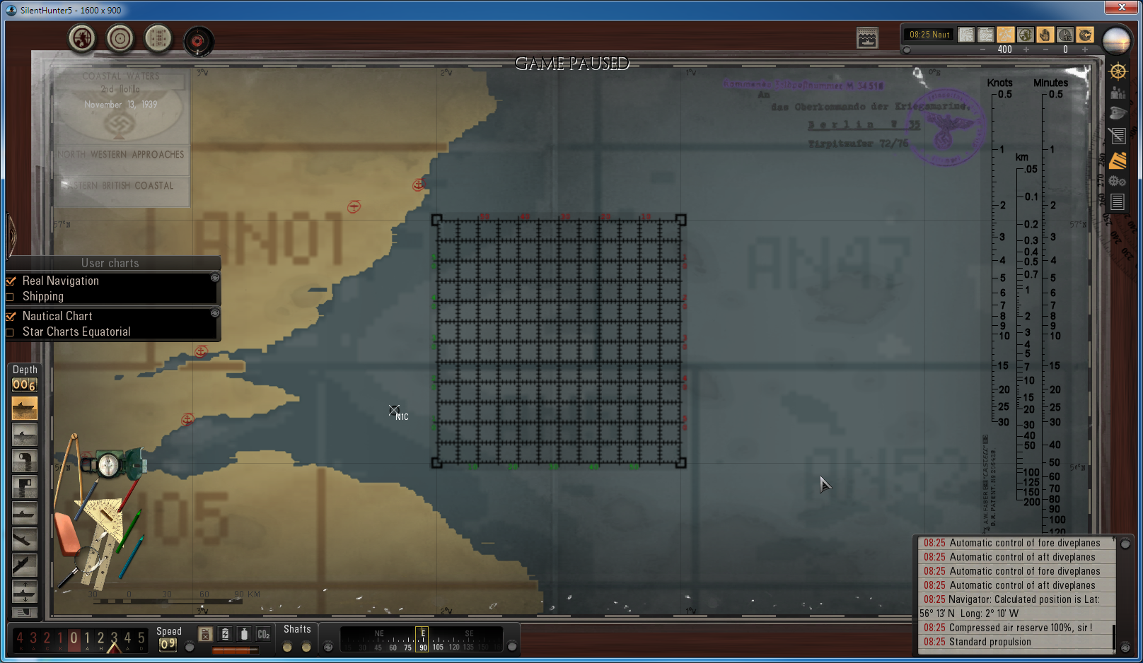
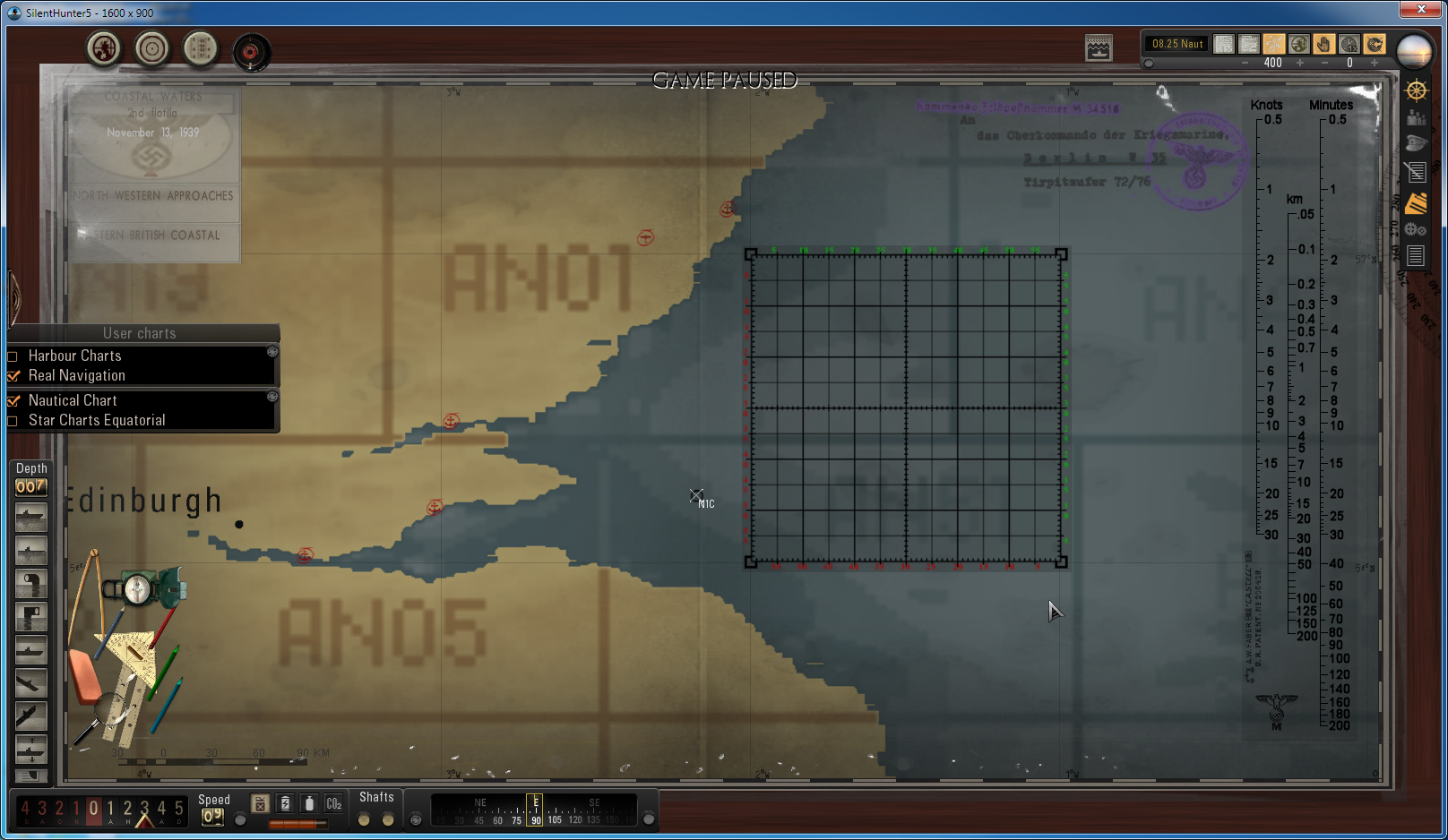
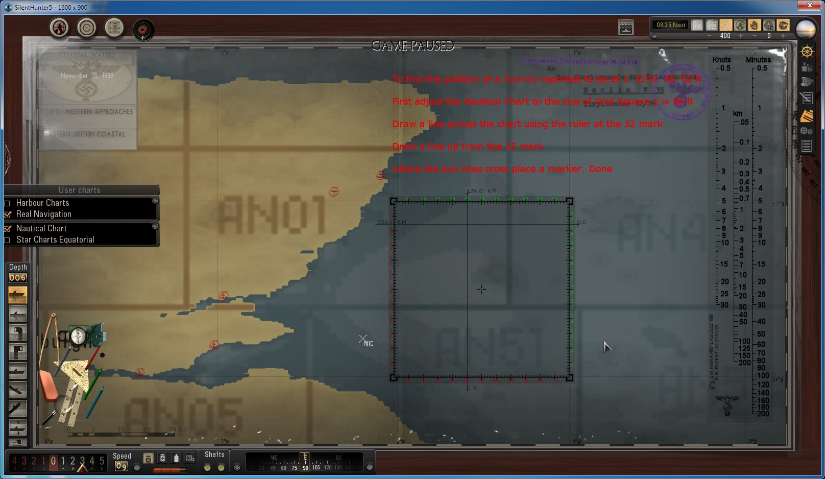
Great stuff Les...getting ready to get into celestial navigation and these will good for placing fixes accurately as well. Here are the first two victims, plotted
and hunted down with the new plotting tool. 
__________________
Best Regards....Kev* "The finest Captain I ever crossed swords and set sail with" |
|
|
|
|
09-25-16, 02:55 PM
|
#10 | |
|
Loader
Join Date: Jun 2014
Location: Netley Abbey, Southampton, United Kingdom
Posts: 90
Downloads: 522
Uploads: 5
|
Quote:
Yeah can't wait for Potus's video on real Nav and Celestial nav by an actual Navigation Officer, glad to see the plotting tool worked been trying all 3 versions and I prefer the 2nd alternative, what's your preference?  Les Last edited by LesBaker; 09-25-16 at 02:56 PM. Reason: Typo error |
|
|
|
|
|
09-25-16, 03:45 PM
|
#11 |
|
Der Einzelgänger
Join Date: Apr 2013
Location: Cairns, Australia
Posts: 583
Downloads: 363
Uploads: 3
|
I haven't tried the third alternative one yet but I would say more than likely that the second alternative will be my preferred version.
Here is a link to a webpage that I printed out and use to get accurate conversions from the headings relayed in the radio contact message for example South-southwest (SSW) to 202.5°, Northeast by east (NEbE) to 56.25° etc. http://routine-life-measurements.blo...ons-north.html I decided to make this into a User Chart because it's so handy and will work well with the new plotting tools. To make room I have removed the Timepiece Board from the plotting tools as I think Vecko has used the available slots for the Harbour charts. Link below...just extract into the MODS folder and install anytime with JSGME if you want to take a look at it.  http://www.mediafire.com/download/4d...User_Chart.zip
__________________
Best Regards....Kev* "The finest Captain I ever crossed swords and set sail with" Last edited by kevinsue; 09-25-16 at 10:52 PM. |
|
|
|
 |
|
|


 Linear Mode

