
|
|
SUBSIM: The Web's #1 resource for all submarine & naval simulations since 1997
|
SUBSIM: The Web's #1 resource for all submarine & naval simulations since 1997 |
|
|
 11-05-11, 10:43 PM
|
#1 |
|
Chief
 Join Date: Mar 2010
Location: São Paulo, Brazil
Posts: 321
Downloads: 462
Uploads: 0
|
Celestial navigation by day
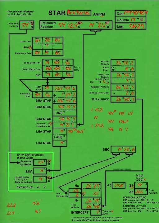
Historically (and nowadays as well) how can you navigate during the daytime using only the Sun as a reference? I've read a bit about the noon shot (finding your long. at noon, UTC difference, 15 degrees\4 min etc) but in one of the movies at youtube a "simulated" cel nav fix was done at sunrise and at sunset. What's this for?

|

|

|
|
11-05-11, 10:55 PM
|
#2 |
|
Silent Hunter
 Join Date: Aug 2006
Posts: 3,528
Downloads: 118
Uploads: 0
|
Someone linked a fantastic "
" video here somewhere which explained the whole process. It relies on predetermined tables though - basically a list of the position of the sun at given times from given locations.
So you use the sextant to mark the sun's location at a specific time. You then estimate a location near to where you think you are given all the tables and stuff and figure out how far away from that point your assumed position is. This results in a line you could be along. Do it again an hour later (giving the sun time to move quite a bit) and measure it again, resulting in another possible position line. Where the two lines meet is where you are. At night you could simply take another reading from another star, but using the sun alone you need to triangulate via a second sun reading. I guess the sunset and sunrise (and noon) checks are easiest since you're more likely to have knowledge of sunrise/sunset times then you are to have the multiple books of where the sun is at a certain time from the video? |
|
|
|
|
11-06-11, 07:47 AM
|
#3 |
|
Chief
Join Date: Mar 2010
Location: São Paulo, Brazil
Posts: 321
Downloads: 462
Uploads: 0
|
thanks for the info kylania, I am doing some experiments in SH4. BTW, do you apply Celnav in any SH? If yes what is your method?
|
|
|
|
|
11-06-11, 09:00 AM
|
#4 |
|
Navy Seal
 Join Date: Mar 2007
Location: DeLand, FL
Posts: 8,900
Downloads: 135
Uploads: 52


|
You can forget about the sky being anywhere near good enough in SH4 to do ANY celestial navigation from it. The only celestial navigation that can be done comes from knowing the position of the sub, putting those figures into a planetarium program and then doing the celestial navigation from there. SH4 was never meant to be a night sky simulation and it is not. It has a sky. That sky, especially solar system positions, is not accurate for date and time.
Typically, what is done with the Sun is meridian transit times. You have an accurate chronometer set for GMT. You get the time the sun passes its highest point. That is noon. The difference between GMT and your transit time is your longitude. This is not particularly accurate due to the size of the sun and the interpolation between precisely timed observations necessary to determine transit time. But it will get you in the same zip code.
__________________
Sub Skipper's Bag of Tricks, Slightly Subnuclear Mk 14 & Cutie, Slightly Subnuclear Deck Gun, EZPlot 2.0, TMOPlot, TMOKeys, SH4CMS |
|
|
|
|
11-06-11, 09:06 AM
|
#5 | |
|
The Old Man
 Join Date: Nov 2003
Posts: 1,304
Downloads: 214
Uploads: 0
|
Quote:
__________________
-Arlo |
|
|
|
|
|
11-06-11, 11:03 AM
|
#6 | |
|
Eternal Patrol

 Join Date: Nov 2002
Location: High in the mountains of Utah
Posts: 50,369
Downloads: 745
Uploads: 249


|
Quote:
__________________
Never do anything you can't take back. Rocky Russo |
|
|
|
|
|
11-08-11, 05:44 AM
|
#7 | |
|
Chief
Join Date: Mar 2010
Location: São Paulo, Brazil
Posts: 321
Downloads: 462
Uploads: 0
|
Quote:
When I started playing SH series and was introduced to the TDC I was puzzled at first. After using auto-target I got bored. It was simple point-and-shoot. Just lock, wait for at least a yellow or preferably green triangle on the target and fire the fish. After some patrols the game kind of lost its glamour to me. After joining subsim and reading a lot about manual targeting, I've decided to perform a simple target interception in real time. After lot of plotting and some math I fired and scored 2 hits out of 3. Then ran for my life from 2 DDs. That took at least 2 hours of depth charge attacks and praying not to be hit. The self-pride I had from doing everything on my own plus the successful escape (plus my almost breakdown from the charges) were things that I hadn't experienced in a long time from a PC game. So I've kind of felt what those submariners had to endure for real. So manual target is still a learning tool. I'm not 100% there but I'm on the way. Same thing for Cel nav. I was only doing Navigation with our zero error navigator and I felt that it was too perfect even for real life with GPS. After doing some research again I decided to try it out with Stellarium and I was offset just a few miles from my DR. So I am more immersed now in the sim than before. I am currently doing the cel nav calculations using an iPad app but in the future will try to do it by hand. The good thing is that Cel nav is optional. I am even complaining that in Dangerous Waters you can't align your SINS. The SINS is always 100% accurate. |
|
|
|
|
|
11-08-11, 05:16 AM
|
#8 | |
|
Chief
Join Date: Mar 2010
Location: São Paulo, Brazil
Posts: 321
Downloads: 462
Uploads: 0
|
Quote:
|
|
|
|
|
|
11-06-11, 02:54 PM
|
#9 | |
|
Silent Hunter
Join Date: Aug 2006
Posts: 3,528
Downloads: 118
Uploads: 0
|
Quote:
|
|
|
|
|
|
11-06-11, 04:19 PM
|
#10 |
|
The Old Man
Join Date: Nov 2003
Posts: 1,304
Downloads: 214
Uploads: 0
|
Well, I may reconsider. Anything with the word sex-tent in it is worth exploring if there's a co-ed crew (that was bad but then I'm not known for the best puns).

__________________
-Arlo |
|
|
|
|
11-08-11, 05:48 AM
|
#11 | |
|
Chief
Join Date: Mar 2010
Location: São Paulo, Brazil
Posts: 321
Downloads: 462
Uploads: 0
|
Quote:
|
|
|
|
|
|
11-08-11, 06:30 AM
|
#12 | |
|
中国水兵
 Join Date: Dec 2010
Posts: 278
Downloads: 91
Uploads: 0
|
Quote:
 Mod: SH5 true navigation = SH5 real navigation without any AI |
|
|
|
|
 |
| Thread Tools | |
| Display Modes | |
|
|


 Hybrid Mode
