
|
|
SUBSIM: The Web's #1 resource for all submarine & naval simulations since 1997
|
SUBSIM: The Web's #1 resource for all submarine & naval simulations since 1997 |
 03-27-06, 04:38 PM
|
#1 |
|
Grey Wolf
 Join Date: Mar 2005
Location: United States
Posts: 777
Downloads: 28
Uploads: 0
|
 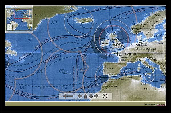 The goal of this project is to make a html interface that will allow access to a any zoomable map or aerial reconnaissance photo within 1 click while playing sh3 in windowed mode. This application will be released in packs since it is html is modular...all that will be required in its final install is the interface that will link them all together. This gives you the option to download what you like. Unlike in game navmaps these maps can be customized or made to how you want them in any level of detail. So no more game engine restrictions when it comes to making the maps you want! Current Map Packs available for download: Default SH3 Campaign Map (11 MB) http://rapidshare.de/files/16589192/...n_Map.rar.html Kriegsmarine Map No.3270 (English Channel) (14 MB) http://rapidshare.de/files/16596473/...annel.rar.html Mirror: http://hosted.filefront.com/TikigodsMods/ Tutorial on how to build your own. http://www.subsim.com/radioroom/showthread.php?t=91244 In development: -Minefield Maps -Precise Depth Sounding Chart Participate here! http://www.subsim.com/radioroom/showthread.php?t=99297 -Black and white Harbor Reconnaissance photos provided by your very own Luftwaffe! Potential Releases -Maps related to campaigns (Tonage War, Grey Wolves, Uboat Aces, etc.) -Real World Kriegsmarine Maps http://U-Boot.Realsimulation.com Please use this post...for your ideas or to share your custom maps you have created using the tutorial I mentioned above. Last edited by Tikigod; 10-10-06 at 01:13 AM. |

|

|
|
03-27-06, 05:56 PM
|
#2 |
|
Grey Wolf
Join Date: Mar 2005
Location: United States
Posts: 777
Downloads: 28
Uploads: 0
|
-------------------------------------------------------------------------------------
My Precise Depth Chart Idea ------------------------------------------------------------------------------------- I was thinking in order to make an accurate depth chart we can either.... a) have everyone post sections of soundings that they record on their patrols to share and assemble here with other captains...(this will make the readings not exact ...there will be room for error...and someone could lie simulating a change in the seafloor or a underwater mound that wasn't noted) or b) try to find a lazy way of extracting the data from the game and just make the charts. (not realistic but, exact, precise, and no error since we will pull data from game if it is possible) Which would you prefer? a) is only option available right now unless someone can figure out how to pull the depth data out. According to ref (who is working on the Terrain Editor) he was only able to find the color variations as the real depth are embedded in the exe. ------------------------------------------------------------------------------------- In any case we now have a functioning hi-res map to use that can zoom down and display accutrate/precise depth measurements and terrain of the sh3 environment! rather than use the difficult limited features of the game navmap. My goal for the precise depth sounding chart is to make a map as accuarte as the kriegsmarine one pictured here using this software: 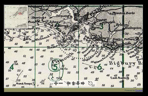
|
|
|
|
|
03-27-06, 06:12 PM
|
#3 |
|
Watch
 Join Date: Jul 2003
Location: Davy Jone's Locker
Posts: 15
Downloads: 0
Uploads: 0
|
Great idea Tikigod. I've always lamented the lack of depth charts especially when chasing convoys inbto shallower waters.
Option A sounds fine especially when you take into account the slight varience from sounding to sounding. It would make those few meters depth when hiding from Zerstorers in the shallows, even more intense!. Looking forward to this. |
|
|
|
|
03-27-06, 06:43 PM
|
#4 | |
|
Grey Wolf
Join Date: Mar 2005
Location: United States
Posts: 777
Downloads: 28
Uploads: 0
|
Quote:
http://www.subsim.com/phpBB/viewtopic.php?t=50425 I figured it would be alot more entertaining this way and besides its alot more accurate then using data in the color method....I have seen canyon drops near some islands..that you really can't record by pulling color data.... |
|
|
|
|
|
03-29-06, 01:09 PM
|
#5 |
|
Admiral
 Join Date: Jan 2006
Location: Spain , Crossing Gibraltar!
Posts: 2,292
Downloads: 202
Uploads: 1
|
Sorry Tiki but is does this works without the window mode, i mean in the normal 1024x768...????
  This option rocks mate!
|
|
|
|
|
03-30-06, 11:06 AM
|
#6 |
|
GWX Project Director

Join Date: Jul 2005
Location: The Republic of Texas
Posts: 6,993
Downloads: 124
Uploads: 0
|
Very cool modding direction you have chosen Tikigod!!!
Way to go man! |
|
|
|
|
03-30-06, 03:14 PM
|
#7 |
|
Sailor man
 Join Date: Sep 2004
Location: Madrid, Spain
Posts: 47
Downloads: 142
Uploads: 0
|
Very interesting. I love that channel Map.
Keep the good work.
__________________
Backman. 24th Unterseebootsflotille Geweih member,. WPL Member #55  
|
|
|
|
|
10-10-06, 06:39 AM
|
#8 |
|
Stowaway
Posts: n/a
Downloads:
Uploads:
|
this is already online since ...
http://uboatcharts.realsimulation.com Thanks for copying and using charts from UBRS ! |
|
|
|
10-10-06, 06:52 AM
|
#9 |
|
Watch
Join Date: Aug 2006
Posts: 16
Downloads: 0
Uploads: 0
|
I had an idea about this. Feel free to shoot me down in flames.
Rather than posting screenshots I thought you could take angles from the 'corners' of the KM grid as a reference to triangulate the position of the sounding. Take a look at this (aplogies for the crude sketch): 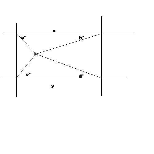 If you set a standard like the angles were always measured from the horizontal line to the u-boat then you'd get a pretty accurate fix for the sounding. You could then state that all emails/sounding reports must have a format of something like DEPTH/ANGLE A/ANGLE B/ANGLE C/ANGLE D i.e. 56/30/32/47/86 (don't try to draw these, I made them up in my head) This could then be interpreted by a program later, or just used as a standard for the fields. Let me know if this sounds complete bollocks or not. |
|
|
|
|
10-10-06, 06:59 AM
|
#10 |
|
Watch
Join Date: Aug 2006
Posts: 16
Downloads: 0
Uploads: 0
|
Ah, I appear to be replying to 6 month old topics. Oops. I wonder if this is still going?
|
|
|
|
|
10-10-06, 08:25 AM
|
#11 |
|
Grey Wolf
Join Date: Aug 2006
Location: Augusta, Maine USA
Posts: 905
Downloads: 170
Uploads: 0
|
I want , I want
|
|
|
|
|
10-10-06, 09:34 AM
|
#12 | |
|
Silent Hunter
 Join Date: Aug 2006
Posts: 3,528
Downloads: 118
Uploads: 0
|
Quote:
 
|
|
|
|
|
|
10-10-06, 09:40 AM
|
#13 |
|
Watch
Join Date: Aug 2006
Posts: 16
Downloads: 0
Uploads: 0
|
Quite. My apologies.
|
|
|
|
|
10-10-06, 09:49 AM
|
#14 |
|
Ocean Warrior
 Join Date: May 2005
Location: New Castle of Delaware
Posts: 3,231
Downloads: 658
Uploads: 0
|
Better to keep it ongoing.
__________________
Gary No Borders, No Language, No Culture =s No Country I'm a Deplorable, and proud of it. |
|
|
|
|
10-10-06, 09:58 AM
|
#15 | |
|
Silent Hunter
Join Date: Aug 2006
Posts: 3,528
Downloads: 118
Uploads: 0
|
Quote:
This was a great idea to map the waters when it was posted eariler in the year and it still is a great idea. But because this is a new effort it should have been given a new post as Tikigod did here but instead of referencing this outdated post, all the new information should have been in the new post. Edited due to my browser being bad. Last edited by kylania; 10-10-06 at 10:52 AM. |
|
|
|
|
 |
|
|


 Linear Mode

