
|
|
SUBSIM: The Web's #1 resource for all submarine & naval simulations since 1997
|
SUBSIM: The Web's #1 resource for all submarine & naval simulations since 1997 |
 02-12-17, 05:21 AM
|
#1 | |
|
Girt by Sea

Join Date: Mar 2015
Location: Red Route 1
Posts: 391
Downloads: 176
Uploads: 40

|
Hi guys,
Just a quick question - I've been slaving away on my Virgina Capes Map - it's coming along - but I've only completed the northern ranges so far... 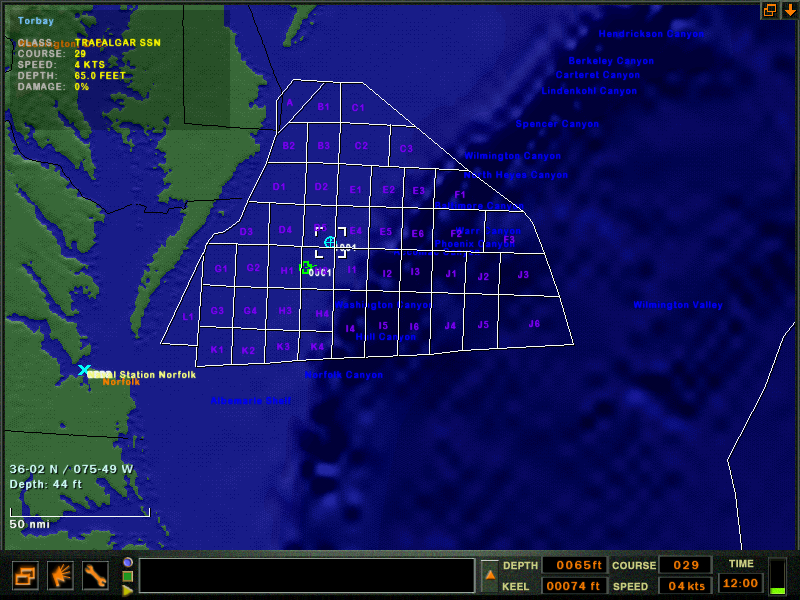 Looking at the mission file in notepad, it has the lines described as: Quote:
Question is, do you recognise the coordinates above? Is there a way to convert them to lat/long? If there is, the map will be hyper-accurate and much, much quicker to make! Cheers guys Stew |
|

|

|
|
02-12-17, 11:34 AM
|
#2 |
|
Seasoned Skipper
 Join Date: Nov 2006
Posts: 742
Downloads: 136
Uploads: 6
|
Map lines/objects are related only to "main coordinates"
VERSION 3 OWNALLIANCE 0 DIFFICULTY 1 TOTALNUMSIDES 0 NUMDRIVEABLES 0 MONTH 1 WORLDGRID 2 <- map size. 2 is default but you can try 3 or even 4 (~1500x1500 nmi) LATLONG 51.727554 159.503586 <- "main coordinates" for terrain map ; SEASTATE 3 MDR 0 0 0 BOTTOMTYPE 0 TIMEOFDAY 12 WEATHER 0 CLOUDHEIGHT 4500 SSP 0 MAPLINES LINE 193.638031 346.712830 318.119354 216.911774 END If you add 2 to red marked values (LATLONG 53.727554 161.503586), map lines coordinates stay the same but terrain map will be moved. 
|
|
|
|
|
02-12-17, 03:08 PM
|
#3 | |
|
Lieutenant
 Join Date: Sep 2003
Location: Oeiras, PORTUGAL
Posts: 258
Downloads: 152
Uploads: 0
|
Quote:

__________________

|
|
|
|
|
|
02-12-17, 05:01 PM
|
#4 |
|
Seasoned Skipper
Join Date: Nov 2006
Posts: 742
Downloads: 136
Uploads: 6
|
WORLDGRID 4 could be interesting option for missions with controlable SSBN's
|
|
|
|
|
02-12-17, 05:11 PM
|
#5 | |
|
Good Hunting!

Join Date: Apr 2014
Location: Beantown
Posts: 776
Downloads: 15
Uploads: 1

|
So the standard map size is 600 nmi x 600 nmi. The coordinates correspond to miles from the TOP LEFT corner of the map in the mission editor.
So, this line: Quote:
(70.72, 393.76) means 70.72 miles east of the top left corner, 393.76 miles south of the top left corner, etc. etc. (0,0) is the top left, (600,0) is the top right, (600,600) is the bottom right, (0,600) is the bottom left. So, to translate these "map coordinates" into latitude and longitude is not a trivial endeavor. A friend and I made a program a while back to triangulate buoy contacts for you, and it could be modified to do this process of converting LAT/LON to Dangerous Waters "map coordinates". This website here could help you out, I used it to develop my program: http://www.movable-type.co.uk/scripts/latlong.html
__________________
Your friendly neighborhood modern submarine YouTuber. My videos: **Exclusive Look at Modern Naval Warfare!** Dangerous Waters Liu Doctrine (LwAmi Learn to play Dangerous Waters Last edited by FPSchazly; 02-13-17 at 04:27 PM. Reason: confused bottom right and bottom left in the original post |
|
|
|
|
|
02-13-17, 01:28 AM
|
#6 |
|
Girt by Sea
Join Date: Mar 2015
Location: Red Route 1
Posts: 391
Downloads: 176
Uploads: 40
|
Thanks Chazly - and all - great answers!
I think my Maths knowledge is not up to doing those conversions though... I remember a guy once who programed a scientific calculator to convert 1:25000 grid coordinates on a map (to 8 and 10 figures - very accurate) to lat/long coordinates on the globe (is that WGS 84? I can't remember!) He was a very clever guy though...my head hurts just thinking about it! Any help or explanations appreciated - but I realise I might just have to put the lines on by hand and 'mark one eyeball' Cheers guys Stew |
|
|
|
|
02-13-17, 10:19 PM
|
#7 |
|
Good Hunting!
Join Date: Apr 2014
Location: Beantown
Posts: 776
Downloads: 15
Uploads: 1
|
I'm going to try and make a small program that will convert latitude/longitude into map coordinates. I think it could definitely be useful to the community based on what you've shown here and what I've seen before.
__________________
Your friendly neighborhood modern submarine YouTuber. My videos: **Exclusive Look at Modern Naval Warfare!** Dangerous Waters Liu Doctrine (LwAmi Learn to play Dangerous Waters |
|
|
|
|
02-14-17, 12:49 AM
|
#8 |
|
Girt by Sea
Join Date: Mar 2015
Location: Red Route 1
Posts: 391
Downloads: 176
Uploads: 40
|
Thanks Chazly for your help - I know you have a great deal of skill in Mathematics.
I last passed Math when I was 15!  I'd be very keen to try your program, when it's released mate! Stew |
|
|
|
 |
| Thread Tools | Search this Thread |
| Display Modes | |
|
|


 Linear Mode

