Apologies, my explanation wasn't clear, I rushed it.
You wouldn't be able to take a bearing at 281 as that's a relative angle of 79 degrees (if you found yourself seeing something for the first time at that bearing, then you could use the Transferred Position Line in the main post

)
For Doubled AOB it needs to be less than 45 degrees for it to work - and no less than 10 degrees ideally - best results are at around 30 degrees I find.
So on the port side, you can take the first readings from relative bearings 316 up to 350 and on the starboard side 10 to 44.
So it's not the
bearing that you need to double but the
angle. I know it's my fault for not making that clear before. Part of the confusion being what is meant by relative bearing.
So a relative bearing of 330 is an angle of 30 degrees, so it's double is (obviously) 60 degrees which is a relative bearing of 300.
Pretty Pictures and Example
(I find it much easier to explain with images)
So in this example, I plotted your course the same as your example, 303T.
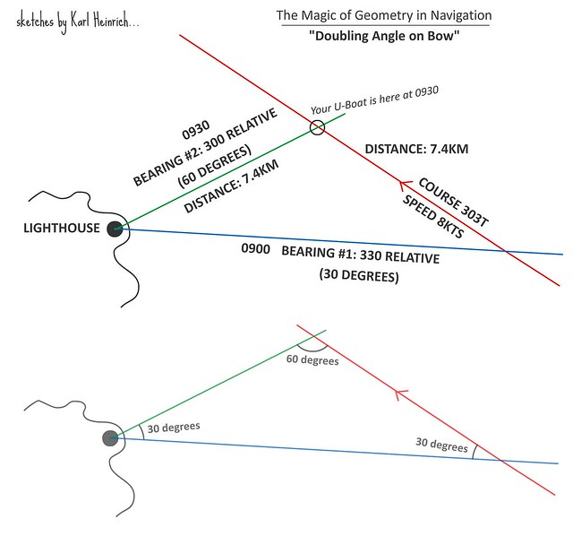
As always it's important to keep your speed and heading constant (I know you already know this LemonA).
Through the UZO or 'scope, you spot a lighthouse ahead. You wait till you know you will get a good bearing for a fix.
At 330 relative bearing on the UZO/Scope you plot the position line on the map and note the time - 0900 GMT. As this gives you 30 degrees AOB to the lighthouse, you keep checking till you have 60 degrees AOB to the lighthouse - relative bearing of 300 (on the UZO/scope reading).
Travelling at 8kts, this takes you 30 minutes - consulting the charts tells you that you have travelled 7.41 KM. You've plotted this on your map and this gives you a nice isosceles triangle - so you know you have two lines of equal length - we know the distance from bearing #2 to your position is the same as the distance travelled along the course.
Check bearing line #2 against your log, you know you've travelled 7.4 km so check with the ruler that bearing #2 is 7.4 km. If you've stayed on course this should be where line #2 and your course line meet. If not, then you are roughly where your ruler line ends at 7.4km...
I feel like I've made this even more complicated now, I really hope it makes sense.
You can also do it where the first bearing is 45 degrees AOB and the second 90 degrees AOB, that's slightly more accurate generally.
--------
As I said, I planned to do a proper tutorial for this too... Trying to translate certain RL things to SH does need a bit of tweaking doesn't it, it's almost impossible to take compass bearings as you would IRL unfortunately.
With this it's much easier to work out the "relative bearing" without ambiguity.
On the plus side of course we know in SH magnetic north = true north so no need to calculate for magnetic deviation.