Quote:
Originally Posted by infernos

Now comes a tricky part , who would put a globe in a U-Boat, you are right its more accurate, but even the ground troops used maps and charts, and in my opinion its more realistic with the maps and charts.
P.S:Maybe they should put a G.P.S in the U-boat  its far easier then charts and maps (just jocking) |
your a pretty smart guy apparently

dont you think that nautical charts correct for the curvature of the earth?
nautical and aeronautical charts MUST correct for curvature as a rule.
if you get nautical charts and connect them end to end while tacking them to a wall you will notice that they form an arc... they are not straight.

eventually... all of the given charts for a given latitude set - given a tall enough wall to tack them to, would form a complete circle.
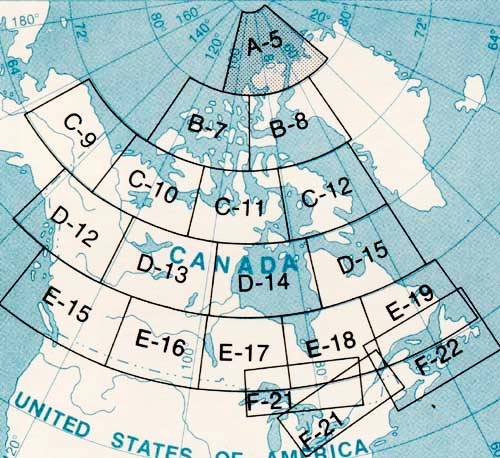
see this image.
The aeronautical charts of the USA

each square represents a different chart.
notic how they follow curvature?
the curvature is less pronounced at the equator and more pronounced at the poles.
notice the greater curvature of canadian charts as you near the polar regions

even wider zoom
thats the difference betweem "MAPS" and "CHARTS"
Maps are typically
Mercator_projections however charts follow the earths curvature as illustrated above.
the flaw with SH3 and SH4 is that not only was the "earth" a Mercator projection of itself, but so were all of the maps in game.
this means that the distance from Brest france to New York is nearly TWICE the actual distance in real life.
by using "charts" and a spherical world... the distances in SH5 would be true to real life, as would all of the shore lines and continental sizes, expanses of the oceans etc.
and Greenland wouldnt be as big as all of asia (in reality its only a fraction of the size which it appears to be in game)
this is something which requires critical and immediate correction for any "Simulation" series which is to be taken seriously