
|
|
SUBSIM: The Web's #1 resource for all submarine & naval simulations since 1997
|
SUBSIM: The Web's #1 resource for all submarine & naval simulations since 1997 |
 07-18-14, 09:15 AM
|
#1 |
|
XO
 Join Date: Jul 2009
Location: Preston, Lancs, UK
Posts: 418
Downloads: 137
Uploads: 0
|
This may be a daft question. I've searched, but I can't seem to find a thread on the subject, but if I wanted to limit the amount I could zoom into the game map, how easy would that be to do and what files would I need to tweak?
Thanks in advance
__________________
Forget death - I'll take dishonour! [SIGPIC][/SIGPIC] TMO 2.5 1.5 Optical Targeting Correction 031312 for TMO 2.5 1.5 OTC Realistic Scopes for TMO TheDarkWraith_DC_Water_Disturbance_v2_0_SH4 Improved Stock environment v3_TMO&RFB TMO_Alt_engine-sounds TMO_Alternate_JS_Radar_performance TMO17_19_different_smoke |

|

|
|
07-19-14, 07:35 PM
|
#2 | |
|
Admiral
 
Join Date: Apr 2005
Location: Dayton, Ohio
Posts: 2,292
Downloads: 474
Uploads: 64


|
With whatever mods you're currently running (don't remove them from your "Activated" JSGME list), go to your game's Silent Hunter Wolves of the Pacific/Data/Menu/cfg/Maps.cfg file. Make a copy of the original "Maps.cfg" file, and put it into its own group of folders. Create a new folder named MY MAP, then create another folder inside it named "Data", then another folder named "Menu" inside the Data folder, then "cfg" folder inside it. Put your copy of the "Maps.cfg" file into the "cfg" folder. Your group of folder will have this hierarchy: MY MAP/Data/Menu/cfg/Maps.cfg. This way you can paste the "MY MAP" group of folders into the JSGME "MODS" folder, and Activate it just like any other mod for testing.
Opening the "Maps.cfg" file with Windows Notepad, you'll find something like this: 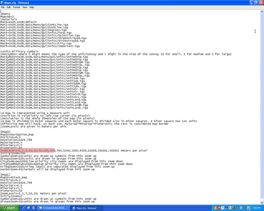 The above is the stock game's file for controlling the Navigation and Attack Map behavior (your modded game "Maps.cfg" file will look a bit different....with different values for some of the parameters). I've highlighted the section you should try changing to suit your plan. Under the [Map0] section (the Navigation Map parameters), find the "ZoomLevels=" heading, then delete the first couple of zoom levels (say to the 50 level)......Use the "File" menu to "Save" your changes, then exit from the file. Open JSGME, and "Activate" your MY MAP mod listed in the left side panel (always have ANY mod "deactivated" {removed} from the game when you make changes to it). Start the game and see what you get. You should find your closest zoom level is not as great as it previously was. One thing you should try to avoid is changing the "ratio" of zoom between levels. I did this back in the early RFB days when I was helping out with SWDW. It made the harbor detail's shift slightly on the Nav Map, putting many of them on dry land!!
__________________
 The HMS Shannon vs. USS Chesapeake outside Boston Harbor June 1, 1813 USS Chesapeake Captain James Lawrence lay mortally wounded... Quote:
Last edited by CapnScurvy; 07-20-14 at 08:22 AM. |
|
|
|
|
|
07-21-14, 12:19 AM
|
#3 |
|
XO
Join Date: Jul 2009
Location: Preston, Lancs, UK
Posts: 418
Downloads: 137
Uploads: 0
|
Thanks muchly. I'll get on that right this second
*Edit* So. Having done what you said I now have a game map that doesn't give me any more detail than a nautical chart, plus I can't zoom in to see the sub in its compass rose, which is exactly what I wanted. If we were within reach of a pub I'd buy you a beer, but since we're not, my heartfelt thanks will have to do. What I found was, when I deleted the first few zoom levels there was a fuzzy black border to the map that hadn't been there previously. When zoomed in this turned out to be a grid composed of individual minutes, also when I tried ctrl+click it put me on dry land. So instead of deleting the zoom levels I didn't want, I just replaced them with the highest level that I wanted. That worked fine as far as getting rid of the grid at low magnification and centering the sub, but the grid was still there when zoomed in - it seems that I zoom in up to the limit I set, and when I go past that I get the grid that i mentioned, even though the zoom level doesn't change. I'm not too fussed about this as it will be quite useful for plotting DR and AP - On a real chart I'd use the latitude scale, but that doesn't work on this one, as you're no doubt aware. Apologies if this is too much detail, but I figured since you shared your knowledge, I'd share my results - It's possible that someone might find them useful. Thanks again
__________________
Forget death - I'll take dishonour! [SIGPIC][/SIGPIC] TMO 2.5 1.5 Optical Targeting Correction 031312 for TMO 2.5 1.5 OTC Realistic Scopes for TMO TheDarkWraith_DC_Water_Disturbance_v2_0_SH4 Improved Stock environment v3_TMO&RFB TMO_Alt_engine-sounds TMO_Alternate_JS_Radar_performance TMO17_19_different_smoke Last edited by in_vino_vomitus; 07-21-14 at 01:20 AM. |
|
|
|
 |
|
|


 Linear Mode

