
|
|
SUBSIM: The Web's #1 resource for all submarine & naval simulations since 1997
|
SUBSIM: The Web's #1 resource for all submarine & naval simulations since 1997 |
|
|
 06-05-17, 09:14 AM
|
#1 | ||
|
Stowaway
Posts: n/a
Downloads:
Uploads:
|
Quote:
 Quote:
About Helgoland, here is what I've found : You can see the lighthouse on the island : 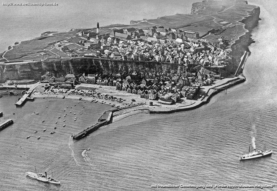 and here the LH :  
|
||

|
|
06-06-17, 12:10 PM
|
#2 | ||||||
|
Navy Seal
 Join Date: Jan 2011
Location: CJ8937
Posts: 8,214
Downloads: 793
Uploads: 10
|
Quote:
Quote:
Quote:
Quote:
 Quote:
The rear light has the shape of cylindrical tower ca. a ca. 15 m in heigth and it is located on the southern shore of the island (Position: 54°10'56.26"N, 7°54'50.58"E, 2 m asl). The front light is placed on top of a metal pole anchored to the sandy soil by a square concrete base and it is located about 110 m SSW of the rear light (Pos: 54°10'52.79"N, 7°54'48.53"E) in the foreshore (thus, in game it can be anchored both to the land or to the sea bottom). The alignment of the two lights shows the safest route to the harbour in Helgoland and to the channel between the two islands (this is what leading lights are generally meant for). Changing the two light's position would defeat their original purpose. On the other hand, I think Düne is a bit too big to be represented as a rock model.  What do you know about Terrain Editor? Creating small islands, sand banks and shoals witin the editor shouldn't be too complicated. Here is a general view of the two islands (Helgoland and Düne): For reference, her is a chart taken from openseamap.org showing the two islands and the relative positions of the leadings lights on Düne: 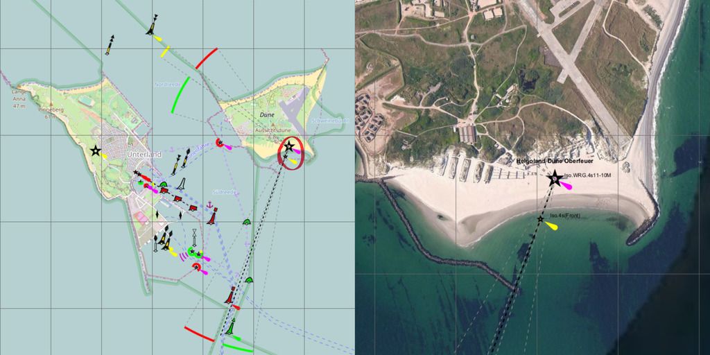 Quote:
I have found a postcard view of the same: 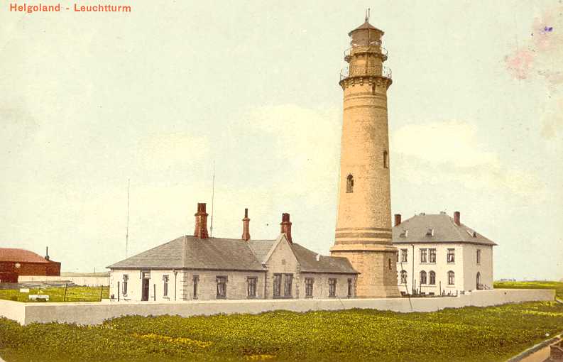 ...and a picture of it together with the first lighthouse built by the British in 1811:  Unfortunately the 1901 lighthouse was destroyed during an air raid in 1945. Interestingly, the aerial picture you have posted also shows the current lighthouse, built in 1941 and then used as a FlaK tower (source: The Lighthouse Directory) 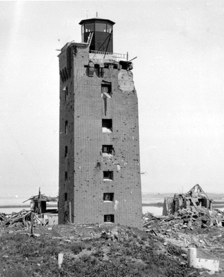 
|
||||||

|
|
|
06-06-17, 08:04 PM
|
#3 | ||
|
Stowaway
Posts: n/a
Downloads:
Uploads:
|
Quote:
Quote:
|
||
|
|
|
06-07-17, 09:07 AM
|
#4 | |||
|
Navy Seal
Join Date: Jan 2011
Location: CJ8937
Posts: 8,214
Downloads: 793
Uploads: 10
|
Quote:
https://drive.google.com/file/d/0B48...?ddrp=1&hl=en# Is there anything similar for SHIII?  Quote:
 Quote:
|
|||
|
|
|
|
06-07-17, 10:17 AM
|
#5 |
|
Stowaway
Posts: n/a
Downloads:
Uploads:
|
I've found this : http://www.subsim.com/radioroom/down...o=file&id=1315
Now two problems : - how does it work ? - what map should we modifiy ? Vanilla or WAC ? ... |
|
|
|
06-07-17, 12:13 PM
|
#6 |
|
Sea Lord
 Join Date: May 2006
Location: U-73
Posts: 1,638
Downloads: 618
Uploads: 0
|
TerrainEditor + Tutorial by ref
|
|
|
|
|
06-07-17, 12:42 PM
|
#7 | |
|
Navy Seal
Join Date: Jan 2011
Location: CJ8937
Posts: 8,214
Downloads: 793
Uploads: 10
|
ops... while writing my previois reply I had missed SquareSteelBar's link (thank you mate!)
 Quote:
|
|
|
|
|
|
06-07-17, 01:58 PM
|
#8 | |
|
Stowaway
Posts: n/a
Downloads:
Uploads:
|
Quote:
|
|
|
|
|
06-07-17, 12:24 PM
|
#9 | |||
|
Navy Seal
Join Date: Jan 2011
Location: CJ8937
Posts: 8,214
Downloads: 793
Uploads: 10
|
Quote:
Quote:
Hopefully someone better informed on the topic we are discussing will pop up and he will shed some light Quote:
- as a package containing only the modified areas, which can be re-merged to any version of the SHIII terrain data using the Extractor/Repacker; - as a ready-to-use terrain data which can be enabled as normal mod using JSGME The first method would contain the download size and it would allow more flexibility, because it would let any player free to choose which terrain data (mega mod) he wants to use as base for the merging of our modifications. The con, is that its installation would be a bit trickier.
|
|||
|
|
|
 |
|
|


 Hybrid Mode
