
|
|
SUBSIM: The Web's #1 resource for all submarine & naval simulations since 1997
|
SUBSIM: The Web's #1 resource for all submarine & naval simulations since 1997 |
 06-06-07, 07:49 AM
|
#76 |
|
Ace of the Deep
 Join Date: Dec 2004
Location: Valhalla: Silent Generation
Posts: 1,149
Downloads: 910
Uploads: 0
|
@Mav:
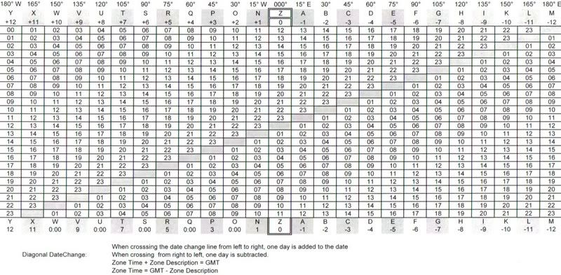
Split image: A way to register degrees of elevation is needed and a way to make the split image function work without being centered "L key" on a ship. -...- Meridian time: (This is just an example of my suggestion) Local date : 4 Feb 42 GMT date : 3 Feb 42 Location: 33° 37' N, 139° 21' E Sunrise: 06:12:00 base time Sunset: 17:14:49 base time 17:14:49 -6:12:00 11:02:49 = # of daylight hrs. divide in half = 05:01:24 add this to sunrise time = 11:13:24 <----this is real noon time in the sim if the sun is bearing 180° (true). Further explanation: At Sunrise-Sunset... The center of the sun is actually 50' (or 0.83°) below the horizon, the upper limb is 34' below the horizon.
__________________
 During times of universal deceit, telling the truth becomes a revolutionary act. ~ George Orwell Last edited by don1reed; 06-06-07 at 08:07 AM. |

|

|
|
06-06-07, 12:25 PM
|
#77 |
|
Stowaway
Posts: n/a
Downloads:
Uploads:
|
So in the case of SH4 we have
Sun Set (center of sun)...18:59:00 Sun Rise (center of sun).-08:36:00 ...................................10:23:00/2 .05:11:30 +08:36:00 13:47:30 witch is 1hour 47min 30sec different from the timezone noon at 12:00:00 the location is 30¨00'00 E and 150¨00'00 N Time Zone K= +10 hours +10 hours +1 hour 47min 30 sec is +11 hours 47 min 30 sec of time difference to GMT aka sunset at this spot should be at 08:11:30 GMT Now im not really sure how all that corrosponds to where my position is. Don.... |
|
|
|
06-07-07, 06:59 AM
|
#78 |
|
Ace of the Deep
Join Date: Dec 2004
Location: Valhalla: Silent Generation
Posts: 1,149
Downloads: 910
Uploads: 0
|
Yeah, Mav, I came to the same conclusion. I was heading back to Pearl from patl off Honshu and came to "all stop" precisley at 32° 08'N, 150° 00' E, (the meridian acctually crossed the tower) and my SR/SS and LAN times were about 1 to 2 hours off from a real Navigation program I also use. My LAN (Local Apparent Noon) was 14:20 (Base time). I presume that the internal game clock will vary throughout the Pacific at this rate.
Navigation with that amount of error is strickly UNSAT. (You will not receive a "GO" at this station.) If there is a "fix" for this anomoly, it may entail making the same experiment at each and every time-zone (Longitudes evenly divisible by 15). Without accurate time and/or the celestial canopy moving in sync with accurate time for the war years, there can be no precise navigation. I still have a sneaky suspicion that heavenly overlay in the sim is nothing but eye-candy. What van did, IIRC, is tc through the sim (SH3) and compiled a table based on the red-light in sim turning on/off, indicating SR/SS. This as we know varies from real sr/ss or when a real navigation pgm says sr/ss occurs, they are not in sync. I believe that I read somewhere in this thread that "someone" should attempt to follow the same procedure to compile a sr/ss table for SH4 as well. ...or, has most of the work been done? Did the Devs incorporate the celestial canopy used in SH3 into SH4 also? I presume they did, due to the quickness of putting SH4 onto the market...same engine...different part of the world.
__________________
During times of universal deceit, telling the truth becomes a revolutionary act. ~ George Orwell Last edited by don1reed; 06-07-07 at 07:27 AM. |
|
|
|
|
06-07-07, 10:00 AM
|
#79 |
|
Ace of the Deep
Join Date: Dec 2004
Location: Valhalla: Silent Generation
Posts: 1,149
Downloads: 910
Uploads: 0
|
 Here's an interesting pic of UL sun just dipping beneath the waves. My location: 28-15N 177-32W. What you see is the orange after-glow. The defined circumference of the sun has just disappeared. Note the time: 18:45. (The interior "RED" light popped on at the same time!) Well guess what...it seems that base time in SH4 is at the International Date Line, just west of Midway Is. 180°. All other times must then be computed by the player as they make their way across the Pacific. 18:45 btw coincides with my TI-86(Starpath) ephemeris calc/nav pgm., for SS at my posit also. Scope: #1 aka Observation scope. Mod: RFB 1.28
__________________
During times of universal deceit, telling the truth becomes a revolutionary act. ~ George Orwell Last edited by don1reed; 06-07-07 at 10:16 AM. |
|
|
|
|
06-25-07, 12:17 AM
|
#80 | |
|
Stowaway
Posts: n/a
Downloads:
Uploads:
|
Quote:
My indications here - starting docked from PEAR HARBOR - is that BASE TIME is timezone X -10 with a 4 minute delay. Ill try going across the pond taking SR and SS at each timezone center. |
|
|
|
|
06-28-07, 02:37 AM
|
#81 |
|
Stowaway
Posts: n/a
Downloads:
Uploads:
|
Remember the fast method.
Note the RedLight BaseTime for Sun Set. Wait for nightfall and sighting of Polaris. Measure Polaris altitude (Hs) Hs - 1 = Lattitude of your boat. (roughly but better then just the Hs) From the Lat. look up SunSet in Van's Almanac. Basetime Sunset is converted to GMT (for Pearl Harbor thats timezone X to GMT) Difference in sunset is found and substracted/or added to the middle of your local timezone(you know aproximately how far you have traveled with speed over time at course) Now you can plot your position at SunSet and extrapolate it with speedovertimeatcourse to your present position. Now stick a new course if necesary to reach your goal. Do that every morning and evening and you will be safe. In the morning its the reverse order of course. First the polaris fix then the sun rise time. |
|
|
|
06-29-07, 04:09 PM
|
#82 |
|
Ace of the Deep
Join Date: Dec 2004
Location: Valhalla: Silent Generation
Posts: 1,149
Downloads: 910
Uploads: 0
|
__________________
During times of universal deceit, telling the truth becomes a revolutionary act. ~ George Orwell |
|
|
|
|
07-11-07, 05:48 AM
|
#83 |
|
Seasoned Skipper
 Join Date: May 2007
Location: Bastogne, Belgium
Posts: 716
Downloads: 86
Uploads: 0
|
Wow !
This mod looks very great ! But also very hard for a newbie like me. It would be possible that you build some training missions with smooth objectives to let us work on the navigation ? |
|
|
|
|
07-11-07, 06:34 AM
|
#84 |
|
Ace of the Deep
Join Date: Jul 2005
Location: Germany's oldest city alive
Posts: 1,066
Downloads: 57
Uploads: 0
|
The only training you really need is to cheat a little at the beginning.
The ctrl+leftclick method has proven valuable but at my installation I could still use the 'plot course' icon, which wouldn't let pe actually plot my course but gave away my exact current position. This and the theoretical knowledge should give you enough opportunity to practice. You can use the cheating methods to compare your results to your exact position and so on. So you can learn while playing the normal career mode Be warned though that sometimes there are some differences between the position you calculated and your actual one, no matter how careful you are. Sometimes it seems as if the time of sunrise isn't really acurate. The sunset times even don't seem to work at all. Read this thread or: http://www.subsim.com/radioroom/showthread.php?t=116837 this one for some experiences we made so far with the mod. The manual that came with it explains the use of the sextant fairly well. Have fun, i. |
|
|
|
|
07-11-07, 09:42 AM
|
#85 |
|
Seasoned Skipper
Join Date: May 2007
Location: Bastogne, Belgium
Posts: 716
Downloads: 86
Uploads: 0
|
Ok thank you.
I try it soon and I hope find the way to exit my own port lol. When I was younger, I was an engineer officer in the merchant navy, but I have never to make the calculation of the road and I always wanted to know how it makes. That will be fun ! |
|
|
|
|
07-12-07, 08:27 AM
|
#86 |
|
Stowaway
Posts: n/a
Downloads:
Uploads:
|
Any update on Kaleuns Freddies Quick Nav Guide ?
The copy I have mentions the following problems 1) We now are there somewhere, so to get a more accurate position we currently (this will change) have to wait for sunrise/sunset to take a GMT time reading (Local time is no good here). 2) When East of GMT the world ends the clock times get messed up making calculations tedious (working on this) Thanks.... |
|
|
|
07-12-07, 09:10 AM
|
#87 | |
|
Ace of the Deep
Join Date: Jul 2005
Location: Germany's oldest city alive
Posts: 1,066
Downloads: 57
Uploads: 0
|
Quote:
|
|
|
|
|
|
07-12-07, 09:47 AM
|
#88 |
|
Stowaway
Posts: n/a
Downloads:
Uploads:
|
Thanks again ischo. I hope to put together a complete doc for virgins like myself to ease the pain of diving into real naviagtion, it looks like it'll open up other subtle aspects of the game as well as provide a very rewarding and realistic experience (i've always hated the GPS nav system of stock)
Combining this with Hitman's work on manual targeting then hopefully we'll start getting some realistic patrol tonnages too. |
|
|
|
02-18-08, 11:04 AM
|
#89 |
|
Electrician's Mate
 Join Date: May 2005
Location: Germany
Posts: 133
Downloads: 66
Uploads: 0
|
Hi Folks,
I am planning to make a long journey with a IX D2 using the Real Navigation Mod: Tranfsering a Monsoon Boat from Lorient, France to Penang, Malaysia. I'm following these thread(s) and understand the problems with the SH weird clock but I didn't grasp on how to navigate on the southern hemisphere with this mod. There is no such thing like Polaris to easily catch the Latitude. The southern Cross and the bright Centauris stars would be a good substitute but alas they "move" around" during the night so I can't simply "shoot" the angle. Is there any solution to this? While I'm not sure whether the Allied Destroyers and ASW planes make my question hypotetical anyway  , I'm nevertheless interested if it's feasible to make such a long journey around half of the globe without getting completely lost. , I'm nevertheless interested if it's feasible to make such a long journey around half of the globe without getting completely lost.Thanks for the help, AndyW
__________________
currently U-200 (Type IXD2) Ltn.z.See Schonder, 2nd patrol (July 1943) [SH3 1.4b + GWX 2.1 @ 90% realism + U-Jagdtools + LRT + Seadbed Repair, DiD] TOTAL: 11 careers, 47 patrols, 1,033 days at sea, 633,585 tons sunk |
|
|
|
|
03-22-08, 05:35 AM
|
#90 |
|
Swabbie
 Join Date: Mar 2008
Posts: 9
Downloads: 56
Uploads: 0
|
Hi,
I'm very new to SH3 or any sub sim whatsoever, and the problem I'm having using this mod is that over great distance (or even medium) and with time compression, the manual course isn't held. Is there an easy way to maintain a steady course other than manual adjustments every so often. I started at 1350 km leg after perfectly navigating to the shoreline from harbour and began the leg fine for about 24 hours. Over the next 24 hours (at 32x compression) I came back and found that the boat had turned 60 degrees off course in the semi-rough water. _________________________ Thanks for the speedy reply, Mikhayl. Last edited by Kravixon; 03-22-08 at 05:48 AM. |
|
|
|
 |
|
|


 Linear Mode

