
|
|
SUBSIM: The Web's #1 resource for all submarine & naval simulations since 1997
|
SUBSIM: The Web's #1 resource for all submarine & naval simulations since 1997 |
|
|
 01-06-17, 07:10 AM
|
#1 |
|
Girt by Sea

Join Date: Mar 2015
Location: Red Route 1
Posts: 363
Downloads: 131
Uploads: 34

|
I finally got around to uploading some of my 'best' maps, guys. It's up on the 'Maps and Missions' section of the Downloads page.
Here are some maps I've made for Dangerous Waters. There are eighteen for you to enjoy. They are essentially 'blank' of triggers, scripts, ships and submarines, for you to make your own missions. All landmarks, features, and EEZ boundaries are marked as accurately as possible. Research Credits go to Wikipedia, Vector Globe Atlas, US policy releases, searates.com (for major ports) and marineregions.org (for EEZs), various news websites, and computer game manuals. All information was accessed from publically available sources. The maps are: Yemen, Kola Peninsula, East China Sea, South China Sea, Spratley Islands, Libya, Bougainville, Persian Gulf, The East Australian Exercise Area (EAXA), Cuba, Greenland-Iceland Gap, Iceland-UK Gap, North Atlantic, Syria, Timor Sea, Black Sea, Baltic Sea and Adriatic Sea. Disclaimer: Naturally, download at your own risk. I take no responsibility for any adverse effects to your computer by downloading these files. Feedback (and requests) welcome via the Subsim forums! Here is a pic of my EAXA Map - the East Australian Exercise Area - Australia's premier east-coast air and naval ranges 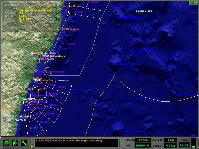 ...And here is my Persian Gulf Map 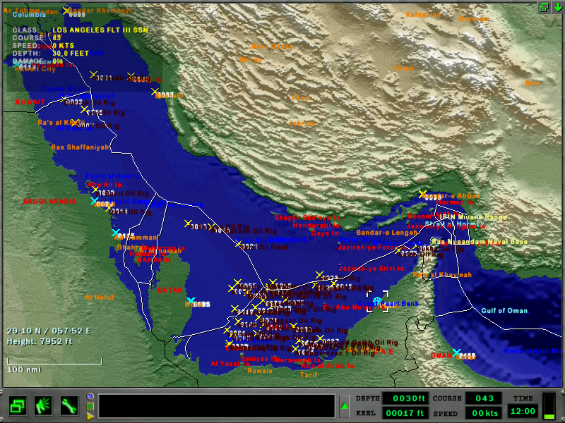 Enjoy! Last edited by Stewy1; 01-06-17 at 07:25 AM. |

|

|
|
01-20-17, 12:35 PM
|
#2 |
|
Stowaway
Posts: n/a
Downloads:
Uploads:
|
Outstanding!
|
|
|
|
01-22-17, 07:11 PM
|
#3 |
|
Stowaway
Posts: n/a
Downloads:
Uploads:
|
Would you consider doing some areas of the US coasts? San Diego and Groton areas come to mind. There sure are some navy training areas that could find use in scenarios... Hint hint...
|
|
|
|
01-25-17, 05:10 AM
|
#4 |
|
Girt by Sea
Join Date: Mar 2015
Location: Red Route 1
Posts: 363
Downloads: 131
Uploads: 34
|
I'm working on the SOCAL Training Range as we speak, mate. I've got about 1/2 of the ranges marked (all by guesses from .pdf published maps - not hard coordinates (I don't know how to find them)). I've already got the bathymetric features marked, and major cities. I just need to mark the EEZ boundary and finish the ranges.
I'd also like to do the Hawaii training ranges in another map.  If any Americans can help with finding the coordinates of the ranges (Australian ranges are published by the civil aviation authority), I'd really appreciate it - it'd make map making easier, quicker and more accurate. Map Pack 2.0 is in the pipeline as we speak. |
|
|
|
|
01-25-17, 10:16 AM
|
#5 |
|
Stowaway
Posts: n/a
Downloads:
Uploads:
|
Nice!
In my opinion, a well designed map adds a lot to a mission, especially the eez's and some land/water marks. Hope you find the info you need - I have no clue about any of this so I can't help at all. Looking forward to v2! |
|
|
|
01-31-17, 05:59 PM
|
#6 |
|
Girt by Sea
Join Date: Mar 2015
Location: Red Route 1
Posts: 363
Downloads: 131
Uploads: 34
|
Just an update on Map Pack 2, boys.
Sadly, my SOCAL map is dying - it's impossible to find the coordinates of the ranges without being in the know (Navy, US pilot, etc.) - I'm not happy with the accuracy of the ranges and with 'measuring' the coordinates with pencil and ruler, the accuracy isn't great and the ranges just don't 'look right' ...but...the good news is that you're being transferred! Coming in the next week or two will be more maps - and the Virginia Capes Range Complex!  Welcome to LANT!
|
|
|
|
 |
|
|


 Hybrid Mode
