SUBSIM Radio Room Forums


SUBSIM: The Web's #1 resource for all submarine & naval simulations since 1997

Go Back   SUBSIM Radio Room Forums > Silent Hunter 3 - 4 - 5 > SH5 Mods Workshop
Forget password? Reset here

Reply
 
Thread Tools Display Modes
Old 02-14-13, 12:56 PM   #91
Trevally.
Navy Seal
 
Join Date: Apr 2007
Location: AN1536 (Orkney)
Posts: 5,451
Downloads: 166
Uploads: 28


Default

Quote:
Originally Posted by gap View Post
If I remember correctly, in New UI's lat/long grid can be toggled on/off from in game (map properties)
This will switch to meters only for the nav officer reporting possition (used in .mis files) so as Obelix says - the lines will remain.
__________________
Trevally Mods for SH5
Trevally. is offline   Reply With Quote
Old 03-26-13, 12:08 AM   #92
TheDarkWraith
Black Magic
 
Join Date: Jun 2007
Posts: 11,962
Downloads: 147
Uploads: 5


Quote:
Originally Posted by Obelix View Post
Yeah, and when TheDarkWraith will can disable the grid of latitude and longitude in *.exe
see here: http://www.subsim.com/radioroom/show...postcount=1553

I said it would take awhile to find at it did.

TheDarkWraith is offline   Reply With Quote
Old 02-10-14, 08:10 AM   #93
Trevally.
Navy Seal
 
Join Date: Apr 2007
Location: AN1536 (Orkney)
Posts: 5,451
Downloads: 166
Uploads: 28


Default

Quote:
Originally Posted by TheDarkWraith View Post
see here: http://www.subsim.com/radioroom/show...postcount=1553

I said it would take awhile to find at it did.


__________________
Trevally Mods for SH5
Trevally. is offline   Reply With Quote
Old 02-10-14, 01:36 PM   #94
Illyustrator
中国水兵
 
Join Date: May 2010
Location: BY
Posts: 271
Downloads: 80
Uploads: 1
Default

Hi captains!
@Trevally.
You can use the "MQK" at your discretion.
Illyustrator is offline   Reply With Quote
Old 02-10-14, 02:32 PM   #95
gap
Navy Seal
 
Join Date: Jan 2011
Location: CJ8937
Posts: 8,214
Downloads: 793
Uploads: 10
Default

Hi Illyustrator,

have you ever thought about integrating your awesome mod with some of the grids it is currently missing?
Seeing OH's objectives and real U-boat patrol areas, adding quadrants to the following zones might be required (areas with higher priority marked in orange):

Greenland Sea (up to the northern tip of Svalbard)
Missing part of the Norwegian Sea
Barents Sea
Eastern Mediterranean (Levantine Sea)
Black Sea
Southern Ocean (between Cape of Good Hope and the Southern coast of Australia)
Indian Ocean (especially along the Eastern coast of Africa, Arabian Sea, Laccadive Sea, Bay of Bengal, Andaman Sea, peninsular Malaysia, Western Coast of Sumatra, Western Australia)
Pacific Ocean (along the Eastern coast of Australia)
__________________
_____________________
|May the Force be with you!|
...\/
gap is offline   Reply With Quote
Old 02-10-14, 03:24 PM   #96
Trevally.
Navy Seal
 
Join Date: Apr 2007
Location: AN1536 (Orkney)
Posts: 5,451
Downloads: 166
Uploads: 28


Default

Quote:
Originally Posted by Illyustrator View Post
Hi captains!
@Trevally.
You can use the "MQK" at your discretion.
That's fantastic Illyustrator thanks - I will make good use of it

Today I have remade half of the patrol missions for the campaign Coastal Waters
Serge is also making upgrades for these missions - so this will half the work and speed up its finish date.

I will post some images when I test the first campaign

Quote:
Originally Posted by gap View Post
Hi Illyustrator,

have you ever thought about integrating your awesome mod with some of the grids it is currently missing?
Seeing OH's objectives and real U-boat patrol areas, adding quadrants to the following zones might be required (areas with higher priority marked in orange):

Greenland Sea (up to the northern tip of Svalbard)
Missing part of the Norwegian Sea
Barents Sea
Eastern Mediterranean (Levantine Sea)
Black Sea
Southern Ocean (between Cape of Good Hope and the Southern coast of Australia)
Indian Ocean (especially along the Eastern coast of Africa, Arabian Sea, Laccadive Sea, Bay of Bengal, Andaman Sea, peninsular Malaysia, Western Coast of Sumatra, Western Australia)
Pacific Ocean (along the Eastern coast of Australia)
Hi Gap
Most of the missions will fall within the grids already made
You are correct about some missing grids - I could only add 50% of the missions around Norway and Russia. Where this is the case - so far I have made them sink missions so that a map marker will be used.
For the patrols within the MQK mod - these will be informed to the player by mission brief and by radio message that they must patrol " Patrol BF2113 in a 150km zone blah blah...." So player must look to the grid and mark their own patrol area

__________________
Trevally Mods for SH5
Trevally. is offline   Reply With Quote
Old 02-10-14, 04:02 PM   #97
Illyustrator
中国水兵
 
Join Date: May 2010
Location: BY
Posts: 271
Downloads: 80
Uploads: 1
Default

Quote:
Originally Posted by gap View Post
Hi Illyustrator,

have you ever thought about integrating your awesome mod with some of the grids it is currently missing?
Seeing OH's objectives and real U-boat patrol areas, adding quadrants to the following zones might be required (areas with higher priority marked in orange):

Greenland Sea (up to the northern tip of Svalbard)
Missing part of the Norwegian Sea
Barents Sea
Eastern Mediterranean (Levantine Sea)
Black Sea
Southern Ocean (between Cape of Good Hope and the Southern coast of Australia)
Indian Ocean (especially along the Eastern coast of Africa, Arabian Sea, Laccadive Sea, Bay of Bengal, Andaman Sea, peninsular Malaysia, Western Coast of Sumatra, Western Australia)
Pacific Ocean (along the Eastern coast of Australia)
Hi, gap.
I am currently working (spare time) on another game design (Mods).
You and Trevally how creative people can continue my project (MQK).
Illyustrator is offline   Reply With Quote
Old 02-10-14, 04:09 PM   #98
Illyustrator
中国水兵
 
Join Date: May 2010
Location: BY
Posts: 271
Downloads: 80
Uploads: 1
Default

Quote:
Originally Posted by Illyustrator View Post
Hi, gap.
I am currently working (spare time) on another game design (Mods).
You and Trevally how creative people can continue my project (MQK).
But, I watch for you constantly.
Illyustrator is offline   Reply With Quote
Old 02-10-14, 04:12 PM   #99
Trevally.
Navy Seal
 
Join Date: Apr 2007
Location: AN1536 (Orkney)
Posts: 5,451
Downloads: 166
Uploads: 28


Default

Quote:
Originally Posted by Illyustrator View Post
Hi, gap.
I am currently working (spare time) on another game design (Mods).
You and Trevally how creative people can continue my project (MQK).


Quote:
The Kriegsmarine (WWII German Navy) employed a very simple yet clever system for quickly locating, reporting and most importantly vectoring its vessels (surface ships and U-boats). This was the so called Grid system. On this page you can see how it was designed and used.

Close up of Grid AE
In the example above Reykjav�k, the capital of Iceland, is located in square AE 48 (the tiny red dot).

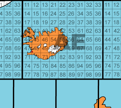
Left: Quadrant 56 Each smaller grid within the main quadrants (like the "56" inside AE) was then further broken down into smaller elements to enable the Kriegsmarine to use designations like AE 5619 (shaded grid).
Reykjav�k, in the map above, is located in grid AE 4874.
The entire world was mapped like that, including areas that never saw any Kriegsmarine operations.


Here it is when added to missions.
Select request mission from the KMO as normal


Check your Captains log for mission info


Mark your patrol area on your map using the cords given


New missions will be sent to you by radio message as you finish your patrols - these can also be checked in the captains log page

__________________
Trevally Mods for SH5
Trevally. is offline   Reply With Quote
Old 02-11-14, 06:08 AM   #100
gap
Navy Seal
 
Join Date: Jan 2011
Location: CJ8937
Posts: 8,214
Downloads: 793
Uploads: 10
Default

Quote:
Originally Posted by Illyustrator View Post
Hi, gap.
I am currently working (spare time) on another game design (Mods).
You and Trevally how creative people can continue my project (MQK).
Quote:
Originally Posted by Illyustrator View Post
But, I watch for you constantly.


Unfortunately the next month I am due to leave for a destination where I won't have a constant internet connection, and also my free time for modding will be heavily reduced. I will check the forum whenever I can though, and I will keep posting from time to time.

Quote:
Originally Posted by Trevally. View Post
Here it is when added to missions.
Select request mission from the KMO as normal

...

Check your Captains log for mission info

...

Mark your patrol area on your map using the cords given

...

New missions will be sent to you by radio message as you finish your patrols - these can also be checked in the captains log page

Excellent Trevally!

One small suggestion, if I can. I think your work would be much easier if you centered OH's patrol areas on the MQK grids visible at the max map resolution (i.e. two letters and two numbers), thus making the last two quadrant numbers "55" by default. This way, you (and OH's players) wouldn't need to guestimate them each time.

Obviously, the optimum would be having square patrol areas matching MQK's grids, but I suppose only circular or oval areas can be set in ME2
__________________
_____________________
|May the Force be with you!|
...\/
gap is offline   Reply With Quote
Old 02-11-14, 07:01 AM   #101
Trevally.
Navy Seal
 
Join Date: Apr 2007
Location: AN1536 (Orkney)
Posts: 5,451
Downloads: 166
Uploads: 28


Default

Quote:
Originally Posted by gap View Post


Unfortunately the next month I am due to leave for a destination where I won't have a constant internet connection, and also my free time for modding will be heavily reduced. I will check the forum whenever I can though, and I will keep posting from time to time.


Excellent Trevally!

One small suggestion, if I can. I think your work would be much easier if you centered OH's patrol areas on the MQK grids visible at the max map resolution (i.e. two letters and two numbers), thus making the last two quadrant numbers "55" by default. This way, you (and OH's players) wouldn't need to guestimate them each time.

Obviously, the optimum would be having square patrol areas matching MQK's grids, but I suppose only circular or oval areas can be set in ME2
Thanks Gap

Yes I was going to do this but it would require ne to move and resize all the zone points within the mission. This would not be to hard to do.

However - I have found a faster way to edit the 333 files required - it is where I load up one mission and remake it to the grid system with messages and objectives updated.
I the load all the other missions from a campaign objective (each campaign has about 5 of 6 groups of 9 mission) and each of these 9 missions have three zones.
I the write down the grid position of these zones.
Keeping the games positions (metres lat and long from centre point) I used editing text software to insert the grids that I have written down.

This is still a very slow way of doing it but lots faster than opening and editing each and every mission (that you be required if I changed the zone position)

So far Serge and I are both looking at this - last night was swapped files to see how each other was doing it

Perhaps we can find a method to allow us to move the zone by editing rather than using ME2

Any suggestions most welcome
__________________
Trevally Mods for SH5
Trevally. is offline   Reply With Quote
Old 02-11-14, 07:14 AM   #102
Trevally.
Navy Seal
 
Join Date: Apr 2007
Location: AN1536 (Orkney)
Posts: 5,451
Downloads: 166
Uploads: 28


Default

What size of patrol area would you expect to see?

Using a 150km zone - I can cover 2 to 3 of these grid squares
__________________
Trevally Mods for SH5
Trevally. is offline   Reply With Quote
Old 02-11-14, 08:41 AM   #103
gap
Navy Seal
 
Join Date: Jan 2011
Location: CJ8937
Posts: 8,214
Downloads: 793
Uploads: 10
Default

Quote:
Originally Posted by Trevally. View Post
Perhaps we can find a method to allow us to move the zone by editing rather than using ME2

Any suggestions most welcome
Automating your work is possible, in theory. The Naval Grid Calculator website is full of theoretical data on the Kriegsmarine grid system. You can get some clues from there, or you can get in touch with its owner (he seems a friendly and open guy by the way). Nonetheless, I am afraid that for our purposes the one practical method is editing patrol areas manually.

Quote:
Originally Posted by Trevally. View Post
What size of patrol area would you expect to see?

Using a 150km zone - I can cover 2 to 3 of these grid squares
I think that 150 km is a good compromise, but it all might also depend on mission/objective type: keeping in mind that a "large square" (i.e. a square designed by two letters) was about 900 x 900 sqkm wide, general "sink tonnage/ship(s) in area" objectives should have the widest radius. "Patrol area" objectives (without tonnage requirements) should be a bit smaller imo, and every mission involving rendez-vous (mostly refuelling and escorting missions), should be quite strict as far as area designation is involved.
__________________
_____________________
|May the Force be with you!|
...\/
gap is offline   Reply With Quote
Reply

Tags
"marinequadratkarte"


Posting Rules
You may not post new threads
You may not post replies
You may not post attachments
You may not edit your posts

BB code is On
Smilies are On
[IMG] code is On
HTML code is Off

Forum Jump


All times are GMT -5. The time now is 08:16 AM.


Powered by vBulletin® Version 3.8.11
Copyright ©2000 - 2024, Jelsoft Enterprises Ltd.
Copyright © 1995- 2024 Subsim®
"Subsim" is a registered trademark, all rights reserved.