
|
|
SUBSIM: The Web's #1 resource for all submarine & naval simulations since 1997
|
SUBSIM: The Web's #1 resource for all submarine & naval simulations since 1997 |
|
|
 06-07-17, 10:17 AM
|
#1 |
|
Stowaway
Posts: n/a
Downloads:
Uploads:
|
I've found this : http://www.subsim.com/radioroom/down...o=file&id=1315
Now two problems : - how does it work ?  - what map should we modifiy ? Vanilla or WAC ? ... |

|
|
06-07-17, 12:13 PM
|
#2 |
|
Sea Lord
 Join Date: May 2006
Location: U-73
Posts: 1,638
Downloads: 618
Uploads: 0
|
TerrainEditor + Tutorial by ref
|

|
|
|
06-07-17, 12:42 PM
|
#3 | |
|
Navy Seal
 Join Date: Jan 2011
Location: CJ8937
Posts: 8,214
Downloads: 793
Uploads: 10
|
ops... while writing my previois reply I had missed SquareSteelBar's link (thank you mate!)
 Quote:

|
|
|
|
|
|
06-07-17, 01:58 PM
|
#4 | |
|
Stowaway
Posts: n/a
Downloads:
Uploads:
|
Quote:

|
|
|
|
|
06-07-17, 02:53 PM
|
#5 |
|
Stowaway
Posts: n/a
Downloads:
Uploads:
|
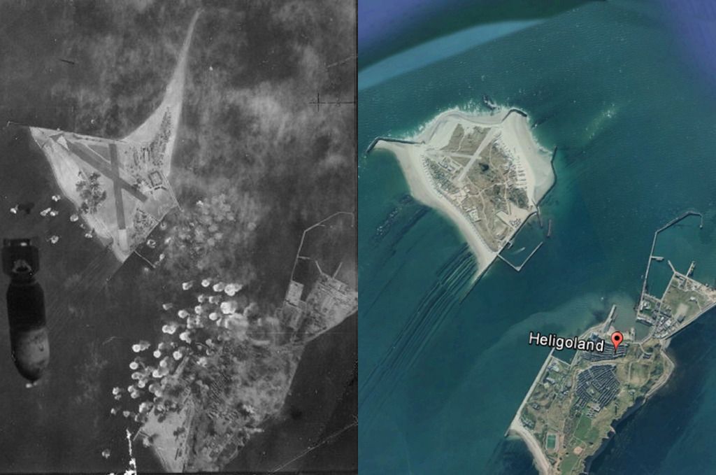
Something interesting : http://www.kartengruppe.it/immagini/...0/0088G-SB.jpg (from : http://www.kartengruppe.it/index.php/nordsee-deutsche-admiralitatskarten)
But although the map was printed in 1943, it's based on a 1913 map. In 1943, the island was bigger, as you can see on this picture : 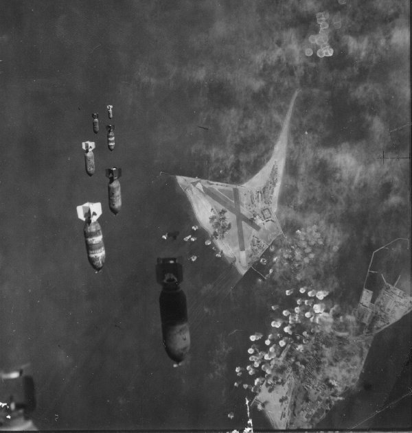
Last edited by Kendras; 06-07-17 at 03:03 PM. |
|
|
|
06-07-17, 03:32 PM
|
#6 | |
|
Stowaway
Posts: n/a
Downloads:
Uploads:
|
Quote:
|
|
|
|
|
06-07-17, 05:12 PM
|
#7 | ||
|
Navy Seal
Join Date: Jan 2011
Location: CJ8937
Posts: 8,214
Downloads: 793
Uploads: 10
|
Quote:
Quote:
I don't know how far the Nazis went with their expansion plan, anyway the sandy beaches of Helgoland and Düne are subject to a strong tidal erosion, and their size and shape might have changed over time. Add to that the fact that after war the Brits tried to sink the main island |
||
|
|
|
|
06-07-17, 06:53 PM
|
#8 | |
|
Navy Seal
Join Date: Jan 2011
Location: CJ8937
Posts: 8,214
Downloads: 793
Uploads: 10
|
Quote:
|
|
|
|
|
|
06-08-17, 04:44 PM
|
#9 |
|
Navy Seal
Join Date: Jan 2011
Location: CJ8937
Posts: 8,214
Downloads: 793
Uploads: 10
|
I have outlined the two islands of Helgoland and Dune on an equirectangular map projection (as the one used in SH games to represent the globe)...
 and I have placed them on a 1deg lat/long quadrant of the size used for SHIII terrain masks. This is the result:  The resolution is poor indeed, but those are the limits imposed by the game. 
|
|
|
|
|
06-09-17, 07:06 PM
|
#10 | |
|
Stowaway
Posts: n/a
Downloads:
Uploads:
|
Quote:

|
|
|
|
|
06-07-17, 12:24 PM
|
#11 | |||
|
Navy Seal
Join Date: Jan 2011
Location: CJ8937
Posts: 8,214
Downloads: 793
Uploads: 10
|
Quote:
Quote:
Hopefully someone better informed on the topic we are discussing will pop up and he will shed some light Quote:
- as a package containing only the modified areas, which can be re-merged to any version of the SHIII terrain data using the Extractor/Repacker; - as a ready-to-use terrain data which can be enabled as normal mod using JSGME The first method would contain the download size and it would allow more flexibility, because it would let any player free to choose which terrain data (mega mod) he wants to use as base for the merging of our modifications. The con, is that its installation would be a bit trickier.
|
|||
|
|
|
 |
| Thread Tools | |
| Display Modes | |
|
|


 Hybrid Mode
