|
|
SUBSIM: The Web's #1 resource for all submarine & naval simulations since 1997
 |
SUBSIM: The Web's #1 resource for all submarine & naval simulations since 1997 |
|
|
 08-18-21, 01:37 PM
|
#1 |
|
Swabbie
 Join Date: Aug 2021
Posts: 6
Downloads: 19
Uploads: 0
|
Hello, im playing sh5 wolves of steel and i get assigned patrol sectors or get asked to investigate a set of lat long cords but i cant pull up any charts to find them. I saw something say press e and you can toggle it but when i press e all i get is the book to identify ships and thats it. can anyone help?
|

|

|
 08-18-21, 01:39 PM
|
#2 |
|
Gefallen Engel U-666
|
GeoBro!

__________________
"Only two things are infinite; The Universe and human squirrelyness; and I'm not too sure about the Universe" |

|

|
 08-18-21, 01:42 PM
|
#3 |
|
Stowaway
Posts: n/a
Downloads:
Uploads:
|
In the window that appears, after pressing the E key, scroll down the mouse wheel to find the required section of the reference book

|

|
 08-18-21, 02:23 PM
|
#4 |
|
Swabbie
 Join Date: Aug 2021
Posts: 6
Downloads: 19
Uploads: 0
|
Thats the thing no window appears when i hit e just the book
|

|

|
 08-18-21, 02:35 PM
|
#5 |
|
Stowaway
Posts: n/a
Downloads:
Uploads:
|
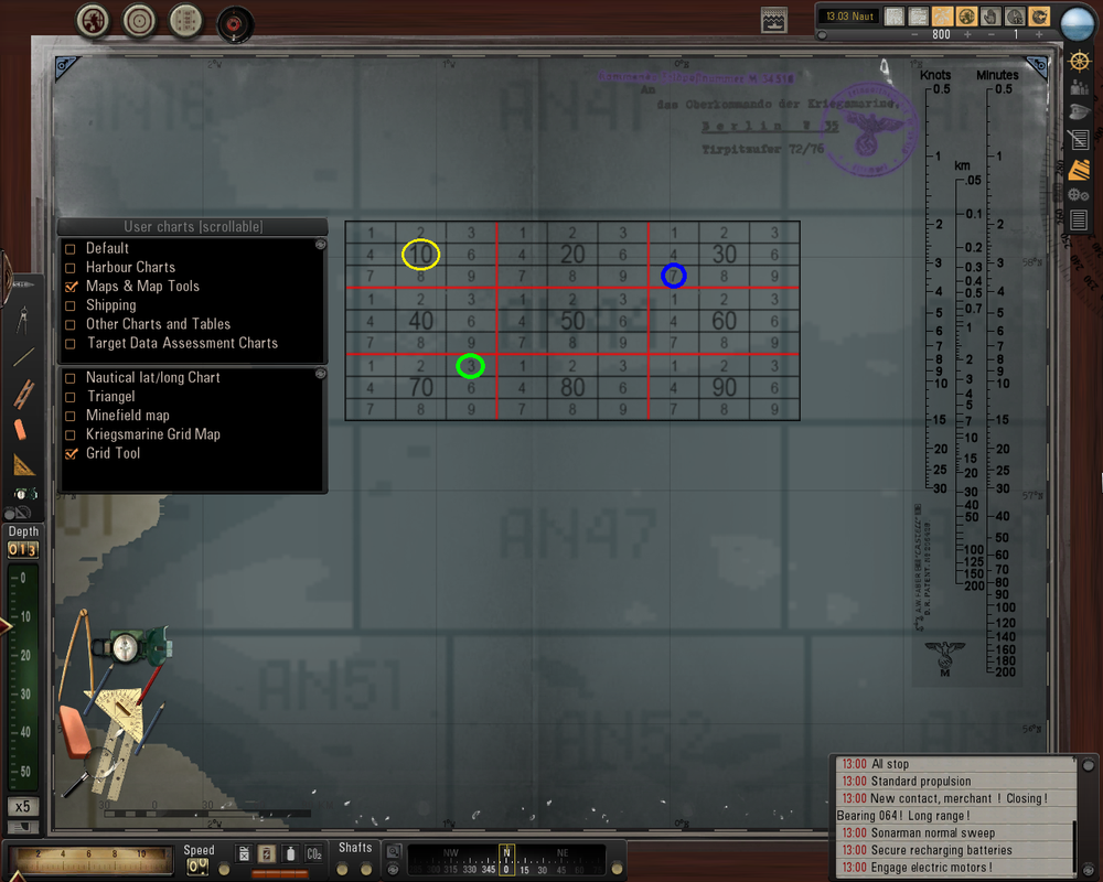
If you need to move to an area with given geographic coordinates, then you do not need to open the charts, because the degrees of longitude and latitude are marked on the map itself. If your task is to move in a square with a given number, then you can call the grid with the layout of the square: Maps & Map Tools ---> Grid Tool. Place a grid over the square and use the map scaling to match the grid dimensions to the square on the map. In my example, the grid is overlaid on square AN44. If I need square AN4410, then I need to move to the place surrounded by a yellow circle. If I need square AN4437, then I need to move to the blue circle. AN4473 - This location is marked with a green circle.
 If you still need angular minutes, then open Maps & Map Tools ---> Nautical lat / long Chart. |

|
 08-18-21, 02:44 PM
|
#6 |
|
Swabbie
 Join Date: Aug 2021
Posts: 6
Downloads: 19
Uploads: 0
|
the thing is that i cant open that user charts scrollable to get to that. thats what i need help with
|

|

|
 08-18-21, 02:44 PM
|
#7 |
|
Stowaway
Posts: n/a
Downloads:
Uploads:
|
Perhaps your window has been minimized and / or moved off the screen (just like in my screenshot you can see only a small piece (tongue) of the Ship Recognition Manual on the left side of the screen). Look carefully around the edges of the screen.
|

|
 |
|
|
