
|
|
SUBSIM: The Web's #1 resource for all submarine & naval simulations since 1997
|
SUBSIM: The Web's #1 resource for all submarine & naval simulations since 1997 |
 04-02-08, 03:05 AM
|
#1 |
|
Stowaway
Posts: n/a
Downloads:
Uploads:
|
[TEC] Ranges going mad - sinking into water problem solved
Hi All
In the quest to refine my Periscope Objective mod i made a mission where a Zinbu Maru is placed at 6 different ranges at AOB 90° The purpose was to calibrate the angular angle to give the correct altitude readouts at all the ranges as i had discovered some problems with the former mod. In the periscope you have 6 lines horizontally below and to the right of the virticle line. Those 6 lines represent a height of 20 ft. at different set ranges. And the Zinbu Maru (Medium European Composite Superstructure Freighter) has very close to 20 ft. to the top of the deck behind the funnel. | ------------------------------------------- Horizontal line |---------- 20 ft. @ 11.000 yards |---------- 20 ft. @ 7500 yards |---------- 20 ft. @ 2500 yards | |---------- 20 ft. @ 1000 yards | |---------- 20 ft. @ 500 yards |---------- 20 ft. @ 400 yards The problem turned out to be unsolvable  Problem is that the image are compressing near the center. This was true for SH3 as well. As far as i could see it happend inside 1° from center only. An offset from this is that the ships are "placed" too far away visualy from around 1000 yards and out. They will appear smaller then they actualy are. It's not a visual problem at 1000 yards as you can still estimate AOB, but it becomes more problematic around 3000 yards. Below are some images of the Zinbu at different ranges. I have marked the line where they SHOULD appear with the deck, and where they DO appear.  Please Dev's - Help us out on this one !! If not with the compression then with the physical placement of the ships. They do get placed further and further away and the error increases with distance. Its not showing up in the stadimeter range - that will be good for all ranges, but it shows on the physical height of the deck/mast. Last edited by Mav87th; 06-07-08 at 11:52 PM. |

|
|
04-20-08, 05:48 AM
|
#2 |
|
Stowaway
Posts: n/a
Downloads:
Uploads:
|
Bump for the Dev's
|
|
|
|
05-12-08, 04:19 PM
|
#3 | |
|
Ocean Warrior
 Join Date: Jan 2008
Posts: 2,909
Downloads: 77
Uploads: 11
|
Quote:
Well, my investigations have concluded you are right, but in a very strange way. What's actually happened, is the measurements are correct, but the waterline is receeding due to the distance and the horizon obscurring it. Some maths calculations tell us that as the Earth's surface is curved, then an object will be obscured by the horizon so you will no longer be able to see its base. As such, you only see the tops of masts over the horizon at long distance. Of course you know this! What's fooling you is that the horizon isn't modelled quite right. The game uses some sort of strange pseudo horizon that makes the ship sink into the water. The further away the object, the further it sinks into the water. This would be correct and acceptable, if the rendered horizon were level with this pseudo horizon, but it isn't. I have done some testing with high power (up to 20x) magnification and have observed the water appears to be flat with no curvature and extends out to what seems to be about 10nm or 20km. At that exact distance objects actually are rendered on the rendered horizon and it is flush with the pseudo horizon. A rise and fall of the camera will show no paralax movement of the pseudo horizon and rendered horizon. Moving back further, so the ship moves more than 20km out, the ship is obviously rendered behind the horizon as you can see over the edge of the end of the sea and the pseudo horizon is no longer a factor, as there is no water to sink the ship into. Moving the camera up and down to change height will cause anything rendered behind the sea plane to rise and fall due to the paralax of the edge of the sea and the object. OK, this is all very hard to explain, perhaps some screenshots would help. the first shot is showing the same ship you used in your example, the medium European composite freighter stationed at distances of 1km, 2km and 4km (there was an 8km one, but it was a bit too fogged and unclear) and zoomed in to 4x, 8x and 16x to give the same relative sizes. The following picture are slightly misleading, as I have arranged them so that the deck lines up, not the waterlines, although it should be noted that the ship does actually sink into the sea, rather than staying at the same height. The picture is only arranged like this to give you a clear indication of the effect. 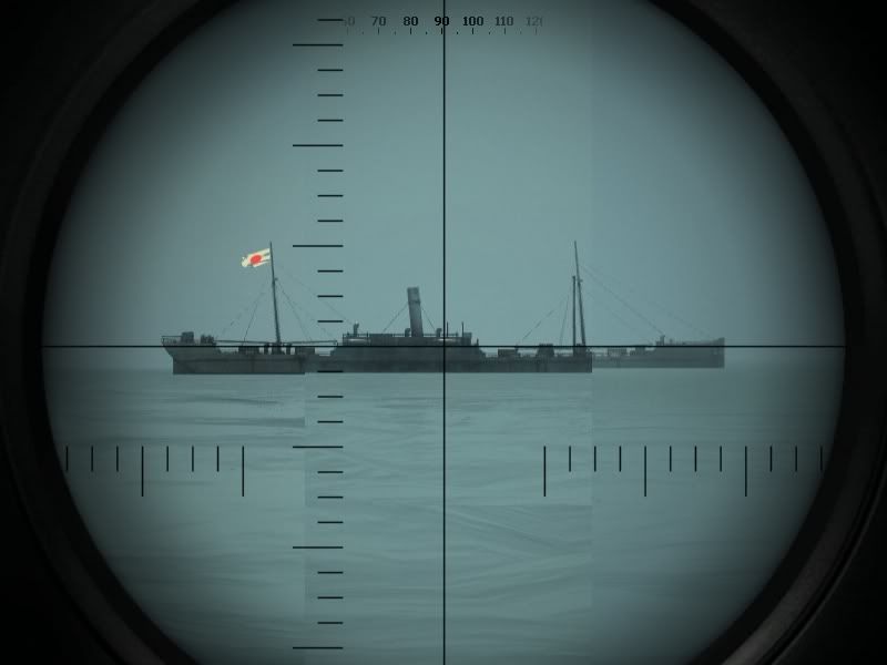 You can see that the horizon on the right hand side appears higher than the horizon on the left hand side of the picture. The horizon stays level, it is only raised due to my arrangement of the picture, aligning the decks up, that the hirizon is not level. The effect of objects being drawn at distances further than the rendered horizon can be seen in the following picture: 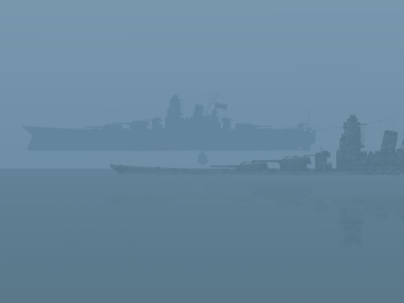 The round blob between the two Yamato ships is actually my submarine and that it has been drawn above the sea, due to the paralax caused by the height and the distance between the submarine (and yamato) and the edge of the sea. For the Yamato in the foreground ( at the bottom), note the height of the deck above the water and then compare that relative height to the height of the guns. Now see in this picture, the true relative heights at close range: 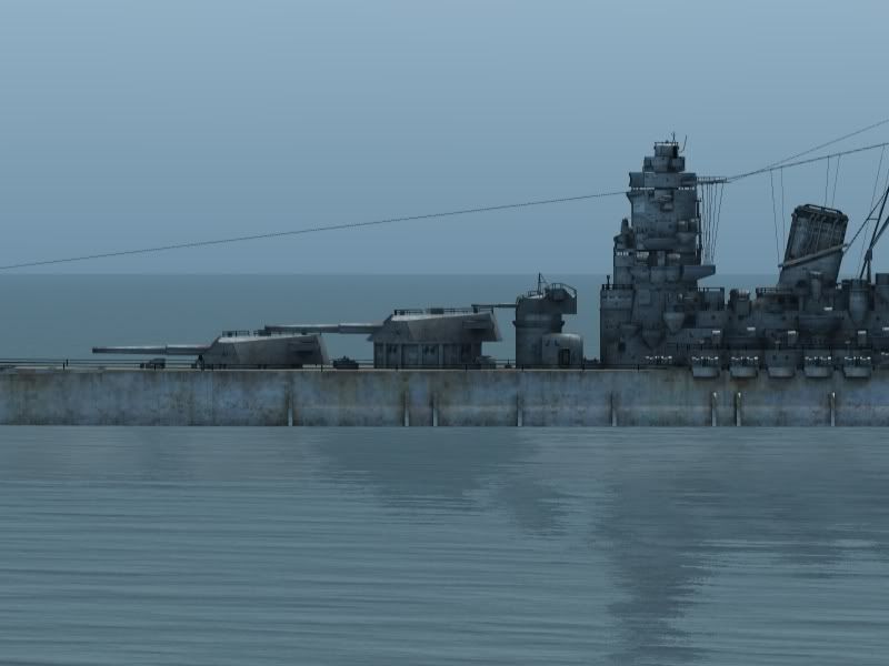 This serves to illustrate the ships sinking into the water effect which causes stadimeter readings to be off. I think the pseudo horizons being calculated and displayed are probably correct, but it's unfortunate that the psuedo horizon effect doesn't meet the rendered horizon, as it makes your sight picture seem as if you can see the waterline when in fact you cannot. Now, it's accurate that in real life situation you would not always be able to see the waterline or mast and the submarine manual advises captains to take measurements from any two horizontal surfaces they could see clearly, the stadimeter is after all just an angle measurer. The angles measured for portions of the ship not including the waterline are correct and can relaibly be used to measure range (I think, but haven't checked), if you know the height difference between the deck and the mast for example, or if you can calibrate your stadimeter with the radar and measure the deck to mast height that way. The pseudo horizon effect seems to start at about 1000 yards / 1km, which may explain why you were able to get accurate ranges up to that point. After that, stadimeter readings taken with the same mast height will give readings saying that the target is progressively further away than it actually is, but the target is drawn at the correct range, it's just got a pseduo horizon. Measuring the horizontal angle would confirm the ships are rendered at the correct distance. Interesting eh? By the way, these pics were taken on an unmodded game installation. It certainly explains the 1 degree compression effect. |
|

|
|
|
05-14-08, 12:51 PM
|
#4 |
|
Navy Seal
 Join Date: Mar 2007
Location: DeLand, FL
Posts: 8,900
Downloads: 135
Uploads: 52


|
Pretty amazing work Neisgeis!
You realize that having the waterline below the horizon also makes mast heights lower in real life? But in real life, you couldn't take a stadimeter reading from that range anyway. Unlike the game, if real life when you magnify size you also magnify movement by the same magnification factor. Instabilities in the atmosphere would make the masthead move around like a drop of water dropped on a hot frying pan most of the time.
__________________
Sub Skipper's Bag of Tricks, Slightly Subnuclear Mk 14 & Cutie, Slightly Subnuclear Deck Gun, EZPlot 2.0, TMOPlot, TMOKeys, SH4CMS |
|
|
|
|
05-14-08, 02:21 PM
|
#5 | |
|
Ocean Warrior
Join Date: Jan 2008
Posts: 2,909
Downloads: 77
Uploads: 11
|
Quote:
In the first composite picture, you can see the waterline and the horizon visible at the same time, with the horizon a bit higher than the waterline. Therefore, the game has drawn the ship so that it appears between the horizon and your submarine, rather than the ship being drawn 'behind' the horizon, obscured by the curvature of the Earth. So when the waterline is behind the horizon, it isn't it's in front of it. |
|
|
|
|
|
05-15-08, 08:46 AM
|
#6 |
|
Stowaway
Posts: n/a
Downloads:
Uploads:
|
Hi again
In respons to Rock Robbins - in the game, as well as in real life we have the exact same problem with a x6 periscope and movement of the submarine. Your camera will pitch and roll as if it was on the top of the mast it self. just like the real view through a periscope. You can clearly see this if you compare a calm sea vs. uncalm and again vs. surfaced and all risen. Stadimeter shots will be with the same dificulty in that regard. With regard to the problem i originaly tried to show here i think i have to explain it again. The lines i have highlighted in the image displays how much 20 ft. of target (the Zinbu Maru's deck height is nearly 20 ft.) should be when the target is at the different ranges... ie. 20 ft. @ 2500 yards --- meens that the 20 ft. (from water to deck of the Zinbu) should fill from the horizon line to the tick. again the nearer you get the more it fills and the further the distance between the tick and the water line. Try to place the Zinbu Maru at different ranges (400, 500, 1000, 2500 yards) in a setup via mission builder and take a look at it through your scope. Only the closest are fitting (depending on your cameras.dat mod and periscope overlay image ofcourse) while the error gets bigger and bigger the further away the ship is. NOT becaurse the ship is "sinking" into the horizon (not even starting to do that at 2500 yards) but as I see it, becaurse the ships gets placed too far away as well as the waterline/horizon effect as Nesgeis explained above. It should be obvious in the ship length as well, so im going to have to try that out before i can say anything about that. I have tried to play around with the AngularAngle factor in the cameras.dat file to see if i could hit a place where the ship would show it self correct, but i was not able to find an Angular Angle that would alow the ship to be in correct height at 400 yards as well as 2500 yards. My current Cameras.dat mod has the angular angle calibrated from a ship placed at 400 yards - So it should give the correct image of the ship sizes compared to what the real skippers saw through their linses. To me thats problematic and tells me that something is wrong with the placement of the ships on the sea regarding to the range they are placed at by the graphics engine. But again to be REAL sure that there is a problem apart from the horizon/waterline i need to check the shiplengths as well - they will not be affected by the waterline problem. Last edited by Mav87th; 05-15-08 at 08:56 AM. |
|
|
|
05-15-08, 04:35 PM
|
#7 | |
|
Admiral
 
Join Date: Apr 2005
Location: Dayton, Ohio
Posts: 2,292
Downloads: 474
Uploads: 64

|
Mav, have you tried just resetting the magnification and not the AngularAngle parameter? I'm wondering if by increasing or decreasing the magnification, leaving the AngularAngle stock for the various scopes. Would that give you a consistent accurrate measurement?
__________________
 The HMS Shannon vs. USS Chesapeake outside Boston Harbor June 1, 1813 USS Chesapeake Captain James Lawrence lay mortally wounded... Quote:
|
|
|
|
|
|
05-16-08, 12:32 AM
|
#8 |
|
Stowaway
Posts: n/a
Downloads:
Uploads:
|
If im right about the ships being placed increasingly further away then they should(or the models being displayed smaller and smaller with increased distance), then it should not matter how the cameras.dat file are modded. But its definitly something worth to try out as well.
|
|
|
|
05-20-08, 04:12 AM
|
#9 |
|
Stowaway
Posts: n/a
Downloads:
Uploads:
|
 I just retested this whole issue out with lenght of ships rather then heights. Test parameters: Vs. a Kiturin Maru that in the ONI manual is listed with a length of 427 ft. The Maru is listed with an A, with indicates that its certain data. Im hoping the dev's made the ship from good drawings  Angular Length and Linier Lenght for this ship placed at 400 yards. is ((427ft. / 3) / 400 yards) * 57,3 = Angular Lenght (20,4°) So the Kiturin Maru should fill 20,4° of vision. In x 1,5 scope (low power) that is 20,4 tick marks in total as each tick mark is 1 deg. In x6 scope (high power) its 81,5 ticks in total as each tick here only represents 0,25 deg. The ship was in mission editor placed at 366 meters (equal to 400 yards), 732 meters, 1098 meters 1464 meters and 6862meters away The targets should fill the below amount of tickmarks in your high power zoom (x6 zoom) and in low power zoom (x1½ zoom) High - Low 81,6 - 20,4 at 400 yards 40,8 - 10,2 at 800 yards 27,2 - 6,8 at 1200 yards 4,4 - 1,1 at 7500 yards The formula to figure this out is the following: (ship lenth in yards / Range in yards ) * 57,3 = Angle in degree's In low zoom each tick is 1 deg. In High Zoom each tick is 0,25 deg. To me it looks as it should regarding ship lenths, so i was wrong in my first perception. Sorry for wasting your time gentlemen 
|
|
|
|
05-20-08, 06:01 AM
|
#10 |
|
Ocean Warrior
Join Date: Jan 2008
Posts: 2,909
Downloads: 77
Uploads: 11
|
Have you tried measuring distance using surfaces that don't sink into the water, like the top of the deck to the top of the mast, or top of the funnel to top of the deck, to see if you get consistent results?
|
|
|
|
|
05-20-08, 11:03 AM
|
#11 |
|
Stowaway
Posts: n/a
Downloads:
Uploads:
|
Not yet - but thats the next test. The ONI references is actualy top of mast/funnel to deck anyway, so its a piece of cake
|
|
|
|
05-23-08, 01:08 PM
|
#12 |
|
Stowaway
Posts: n/a
Downloads:
Uploads:
|
Have anyone of you tried to take stadimeter ranges on distances around 7500 to 9500 yards. It seems to me that one pixel change in stadimeter makes pretty significent jumps in range readout. Although it does read out correctly given the correct placement.
I tested the above mentioned range takes by using the mast height only. Its doable if you take the reading from the mast top as the mast bottom is the lowest part at all visible, then it gives the correct range. |
|
|
|
05-24-08, 02:21 AM
|
#13 |
|
Ocean Warrior
Join Date: Jan 2008
Posts: 2,909
Downloads: 77
Uploads: 11
|
OK, so it's definitely the premature sinking effect I mentioned above, where the waterline is changed, rather than the position on the horizon? I wonder if the range at which they start sinking into the water is moddable in a file somewhere, though I haven't seen anything that might be the control for it. They definitely start sinking into the pseudo horizon before they actually get to the horizon.
|
|
|
|
|
05-25-08, 01:50 AM
|
#14 |
|
Stowaway
Posts: n/a
Downloads:
Uploads:
|
Correct Nisgeis.
I would start searching in the cameras.dat or the scene.dat files. I would belive those to be the most likely that such a thing would be settled in. If you have SHIII installed, could you make a check to see if the same sinking is present in that sim as well..... If its not we could make comparisons between the two sim's files. |
|
|
|
05-25-08, 10:58 AM
|
#15 |
|
Pacific Aces Dev Team

 Join Date: Sep 2002
Location: Spain
Posts: 6,109
Downloads: 109
Uploads: 2

|
This all reminds me of a problem I found some time ago, with patch 1.3, when raising the visibility to more than the stock 9000 yards. I placed the maximum visibility at 20000 yards with mini-tweaker, but the result was not good in that what got moved to 20000 yards was actually the horizon line
I did some tests and concluded that the visibility parameter in SH4 didn't work the same as in SH3. Seems that the physical horizon line -which for a fleet boat watching from the deck should be around 9000 yards moved to 20000, and thus ships did not show "under the horizon" effect until they reached that distance. :hmm: i.e. the hull, then superstructures, finally masts wouldn't get hidden by the horizon line until reaching the visibility limit, and then they would just fade into the horizon fog slightly after. Theoretically, when watching from the bridge you should see any ship further than 9000 yards already "sinking" behind the horizon, and not be able to see the full hull. Of course, at periscope depth through the scope you should see the effect even much closer, -as it is only a few feet above the water-, say 5000-6000 yards (Which actually made distance mesuring above that distance problematic in real life) That has nothing to do with the actual maximum visibility, as you should be able to see a tall smoke column above the horizon even at periscope depth or sea level. But seems that despite actual visibility being 20000 metres in SH4, the horizon line and the earth curvature effect are not perfectly displayed in SH4 
__________________
One day I will return to sea ... |
|
|
|
 |
|
|


 Linear Mode

