
|
|
SUBSIM: The Web's #1 resource for all submarine & naval simulations since 1997
|
SUBSIM: The Web's #1 resource for all submarine & naval simulations since 1997 |
 08-29-09, 11:48 AM
|
#1 |
|
Soundman
 Join Date: Sep 2007
Posts: 149
Downloads: 195
Uploads: 0
|
For SH5, please, please, please make the map a round globe, like in fs9 and fsx, rather than a projection, so Greenland is not the size of the rest of North America combined. Both sh3 and sh4 use a projection for the map, which means at latitudes away from the equator, distances are very exaggerated, in some cases grossly so at the extremes like the norwegian coast. I would by this game if that was the only improvement.
|

|

|
|
08-29-09, 01:14 PM
|
#2 |
|
Subsim Aviator

Join Date: Mar 2007
Location: Texas
Posts: 8,726
Downloads: 146
Uploads: 0


|
I have been a big proponent of this "spherical world" idea for about as long as SH3 has been out.
i think it is a great idea, and is one of the "must have" environmental corrections for SH5.  without the spherical world environment, "realistic" navigation becomes impossible and U-boat and surface ship ranges must be tweaked to astronomical values in order to sail a relatively short distance. With spherical world, navigation by the stars / sun etc becomes highly accurate. and the real world distances between point A and point B also shorten to realistic lengths.
__________________

|
|
|
|
|
08-29-09, 01:42 PM
|
#3 |
|
Officer
 Join Date: Feb 2009
Location: Bucharest - Romania
Posts: 237
Downloads: 16
Uploads: 0
|
Now comes a tricky part , who would put a globe in a U-Boat, you are right its more accurate, but even the ground troops used maps and charts, and in my opinion its more realistic with the maps and charts.
P.S:Maybe they should put a G.P.S in the U-boat  its far easier then charts and maps (just jocking) its far easier then charts and maps (just jocking)
|
|
|
|
|
08-29-09, 02:10 PM
|
#4 | |
|
Subsim Aviator
Join Date: Mar 2007
Location: Texas
Posts: 8,726
Downloads: 146
Uploads: 0
|
Quote:
dont you think that nautical charts correct for the curvature of the earth? nautical and aeronautical charts MUST correct for curvature as a rule. if you get nautical charts and connect them end to end while tacking them to a wall you will notice that they form an arc... they are not straight. eventually... all of the given charts for a given latitude set - given a tall enough wall to tack them to, would form a complete circle. see this image. The aeronautical charts of the USA  each square represents a different chart. notic how they follow curvature? the curvature is less pronounced at the equator and more pronounced at the poles. notice the greater curvature of canadian charts as you near the polar regions  even wider zoom 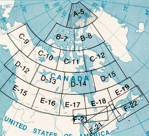 thats the difference betweem "MAPS" and "CHARTS" Maps are typically Mercator_projections however charts follow the earths curvature as illustrated above. the flaw with SH3 and SH4 is that not only was the "earth" a Mercator projection of itself, but so were all of the maps in game. this means that the distance from Brest france to New York is nearly TWICE the actual distance in real life. by using "charts" and a spherical world... the distances in SH5 would be true to real life, as would all of the shore lines and continental sizes, expanses of the oceans etc. and Greenland wouldnt be as big as all of asia (in reality its only a fraction of the size which it appears to be in game) this is something which requires critical and immediate correction for any "Simulation" series which is to be taken seriously
__________________
|
|
|
|
|
|
08-29-09, 02:32 PM
|
#5 |
|
Frogman
 Join Date: Feb 2006
Posts: 309
Downloads: 20
Uploads: 0
|
I would love this, but I'm not getting my hopes up.
I can't help but wonder why they haven't done it in the first place? Just not that important? |
|
|
|
|
08-29-09, 05:00 PM
|
#6 |
|
Commodore
 Join Date: Nov 2004
Location: Right behind you!
Posts: 643
Downloads: 39
Uploads: 0
|
Now it makes more sense why the Chief Quartermaster on my boat used to get so mad when guys called his charts, maps.
|
|
|
|
|
08-29-09, 05:36 PM
|
#7 | |
|
Sea Lord
 Join Date: Aug 2008
Location: Stinking drunk in Eindhoven, the Netherlands
Posts: 1,844
Downloads: 28
Uploads: 0
|
Quote:
__________________
 |
|
|
|
|
|
08-29-09, 06:07 PM
|
#8 | |
|
Subsim Aviator
Join Date: Mar 2007
Location: Texas
Posts: 8,726
Downloads: 146
Uploads: 0
|
Quote:
its a basic mathmatic equation of (A plus or minus B, plus or minus C equals D)
__________________
|
|
|
|
|
|
08-29-09, 07:05 PM
|
#9 |
|
Silent Hunter
 Join Date: Jan 2006
Location: UK
Posts: 3,803
Downloads: 11
Uploads: 0
|
Well, what ever they have gone for now (flat or round) its gonna be far too late to change it.
|
|
|
|
|
08-29-09, 08:08 PM
|
#10 | |
|
Subsim Aviator
Join Date: Mar 2007
Location: Texas
Posts: 8,726
Downloads: 146
Uploads: 0
|
Quote:
going to have to mod the fuel ranges right out of the box. shame that 
__________________
|
|
|
|
|
|
08-29-09, 08:29 PM
|
#11 |
|
Ocean Warrior
 Join Date: Dec 2007
Location: Between test depth and periscope depth
Posts: 3,021
Downloads: 175
Uploads: 16
|
I've spent my fair share of time BSing with the Quartermaster of the Watch and learned a thing or two about charts. This is definitely one of those things that needs to be in the game. Anything less would be uncivilized. Oh and while they're at it they should include buoys as well, and make everyone learn the Rules of the Road.
__________________
USS Kentucky SSBN 737 (G) Comms Div 2003-2006 Qualified 19 November 03 Yes I was really on a submarine. |
|
|
|
|
08-29-09, 10:12 PM
|
#12 |
|
Seasoned Skipper
 Join Date: Apr 2005
Posts: 665
Downloads: 79
Uploads: 1
|
Just have the course tool for the map connect the waypoints with a properly curved line and let the helmsman follow it?
|
|
|
|
|
08-30-09, 01:30 AM
|
#13 |
|
Navy Seal
 Join Date: Apr 2005
Posts: 5,501
Downloads: 19
Uploads: 0
|
A spherical world is more critical than wolfpacks IMHO...
|
|
|
|
|
08-30-09, 02:34 AM
|
#14 | |
|
The Old Man
 Join Date: Mar 2009
Location: Bucharest, Romania
Posts: 1,403
Downloads: 151
Uploads: 0
|
Quote:
I'd love to sail around in the USS Constitution 
|
|
|
|
|
|
08-30-09, 03:17 AM
|
#15 | |
|
Subsim Aviator
Join Date: Mar 2007
Location: Texas
Posts: 8,726
Downloads: 146
Uploads: 0
|
Quote:
hardcore navigation aside. even if the navigation system is a bit dorked up... your VIIC which is supposed to be able to cruise from France to New York and Back with plenty of reserve wont be mysteriously running out of fuel 1/3rd of the way into the return voyage
__________________
|
|
|
|
|
 |
|
|


 Linear Mode

