
|
|
SUBSIM: The Web's #1 resource for all submarine & naval simulations since 1997
|
SUBSIM: The Web's #1 resource for all submarine & naval simulations since 1997 |
 06-17-21, 02:32 PM
|
#166 | |
|
Stowaway
Posts: n/a
Downloads:
Uploads:
|
Quote:
|
|

|
|
06-17-21, 02:49 PM
|
#167 |
|
Seasoned Skipper

Join Date: Jan 2002
Location: Freeman Missouri
Posts: 1,735
Downloads: 1375
Uploads: 0
|
i try watching your video and it just way over my head you lose me basic right at the start my math level is second grade level
__________________
I'll tell you what bravery really is. Bravery is just determination to do a job that you know has to be done. Audie Murphy |

|
|
|
06-17-21, 03:07 PM
|
#168 | |
|
Stowaway
Posts: n/a
Downloads:
Uploads:
|
Quote:
|
|
|
|
|
06-17-21, 03:23 PM
|
#169 |
|
Swabbie
 Join Date: Jun 2014
Posts: 12
Downloads: 19
Uploads: 0
|
Believe it or not, my new years resolution was to get better at math, and since it's now June and I got bored with math problems a few months ago, I think I will count this
As is probably evident, for me personally, the calculation of GHA was the hardest part with all the hour, min and sec adjustments. And GHA seems to be a common denominator in the different methods. I might try the 2 stars graphical map method to get both lat/lon. My understanding is that it can be done at any time regardless of whether the stars are at their upper culmination (this is good b/c I don't think I understand upper culmination yet). However, I think I might cheat and use the same GHA for both star observations and try to take the two observations as quickly as possible. This way I only have to determine one GHA instead of properly determining both GHA values. I assume error will still be quite minimal. |
|
|
|
|
06-17-21, 03:49 PM
|
#170 |
|
Stowaway
Posts: n/a
Downloads:
Uploads:
|
What is good about the graphical method with Messkarte, you actually measure two stars almost simultaneously, then read from the Messkarte LHA of the second star, subtract the SHA of this star from it and add to the obtained SHA Polaris value to get the LHA Polaris and determine your latitude using the correction table to the altitude Polaris. Longitude can be determined to the nearest degree by subtracting SHA from LHA (read from Messkarte), and then subtracting GHA Aries at the time the stars were measured from the obtained value.

|
|
|
|
06-17-21, 11:24 PM
|
#171 |
|
Seasoned Skipper
Join Date: Jan 2002
Location: Freeman Missouri
Posts: 1,735
Downloads: 1375
Uploads: 0
|
so can you take a shot off of the little dripper or is just like a star or a planet
__________________
I'll tell you what bravery really is. Bravery is just determination to do a job that you know has to be done. Audie Murphy |
|
|
|
|
06-18-21, 01:14 AM
|
#172 |
|
Stowaway
Posts: n/a
Downloads:
Uploads:
|
Ultimately, any object can be used for celestial navigation. If it is such a distant object as a star, then it is enough to know its celestial coordinates (declination is a celestial coordinate similar to latitude, right ascension is a celestial coordinate similar to longitude). If the object is close enough to the earth (Sun, Moon), then in addition to the celestial coordinates, it is necessary to take into account the distance to these objects and their geometric dimensions.
|
|
|
|
06-20-21, 02:28 PM
|
#173 |
|
Swabbie
Join Date: Jun 2014
Posts: 12
Downloads: 19
Uploads: 0
|
Just want to point out that the graphical method for lat/long requires very little special math if that's a problem for people. However, I want to make sure I'm doing it right.
My fix was 5.7 km from where the navigator said (granted, the navigator has random error, only reports to arc minute precision and my map work is probably sloppy). But something happened that seemed different from the demonstration video during my map work. My 90 degree LOP line from the Betelgeuse azimuth transfer line actually crossed the azimuth transfer line from Polaris, which doesn't happen in the demonstration video. In the video, only the LOP lines cross. Is this normal, or did I mess something up? Sorry, if I'm messing up the terminology here too. |
|
|
|
|
06-20-21, 02:43 PM
|
#174 |
|
Stowaway
Posts: n/a
Downloads:
Uploads:
|
@CaptBongTrillion, Please provide the date, dead reckoning position, UT + Altitude for Betelgeuse and Polaris, so that I know the details of your task.
As for the intersection of non-LOP lines, this happens quite often and should not distract you. You should clearly see the intersection of LOP 1 and LOP 2 and you need to draw a "spherical transfer" to properly postpone the "map transfer". Last edited by Alpheratz; 06-20-21 at 03:05 PM. |
|
|
|
06-20-21, 03:08 PM
|
#175 |
|
Swabbie
Join Date: Jun 2014
Posts: 12
Downloads: 19
Uploads: 0
|
Sure, thanks for having a look.
1939 Dec 14; 58 N 0 E; PoD=Wilhelmshaven; GHA for 8pm (22° 35.3') Betelgeuse: 22:26:23 UT; 34° 39.7' h; azimuth transfer 144.5°, -21.3 km Polaris: 22:25:25 UT; 59° 1.8' h; azimuth transfer 359.5°, 32.8 km I did end up with two LOP lines crossing, but it just looked different from the video. EDIT: I think the navigator said 58°18'N 0°7'E, so the fix was pretty close to that point. Last edited by CaptBongTrillion; 06-20-21 at 03:53 PM. Reason: wrong PoD |
|
|
|
|
06-20-21, 04:05 PM
|
#176 |
|
Stowaway
Posts: n/a
Downloads:
Uploads:
|
My drawings. "Map transfer" = 16,9 km
Observed position N 58 deg 16,3' E 0 deg 8,5'  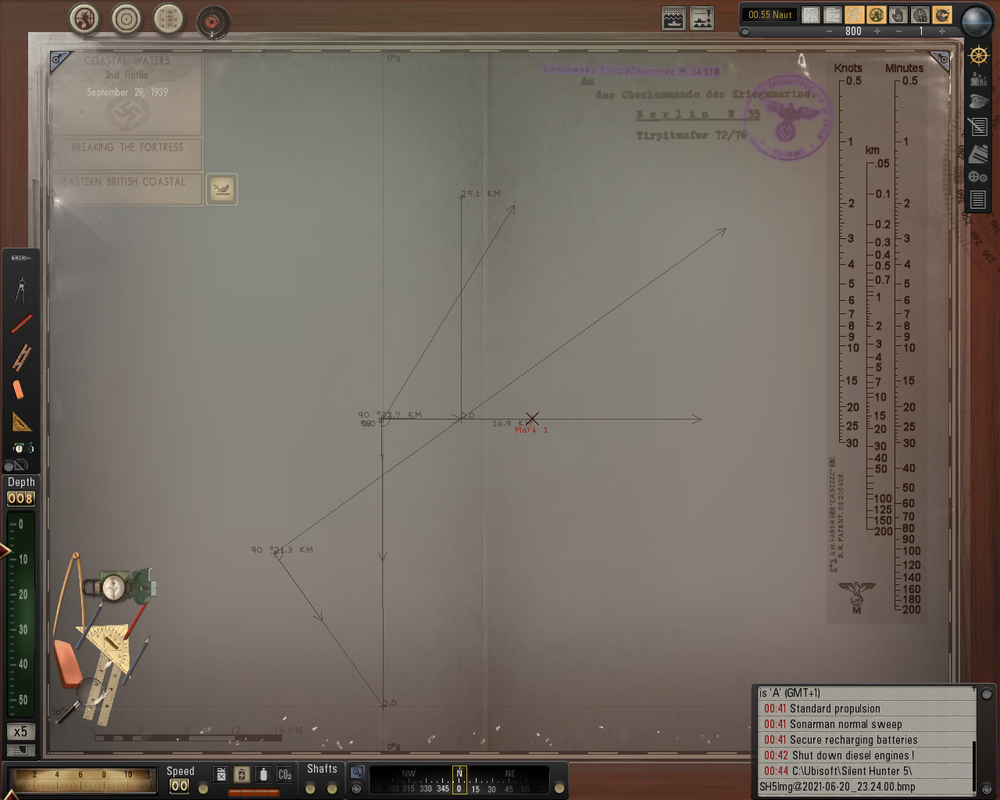 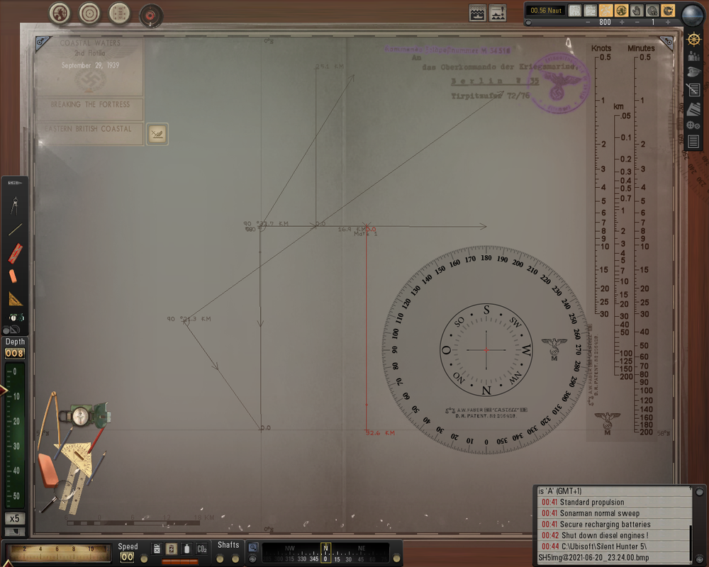
|
|
|
|
06-20-21, 04:17 PM
|
#177 |
|
Swabbie
Join Date: Jun 2014
Posts: 12
Downloads: 19
Uploads: 0
|
Wow cool! That's what I saw on my screen haha. I think that's close enough for me. No more GPS.
|
|
|
|
|
06-20-21, 04:24 PM
|
#178 |
|
Stowaway
Posts: n/a
Downloads:
Uploads:
|
By the way, with the new sextant, when you use UT, PoD is now irrelevant (except when you are calculating local noon or nautical twilight.
|
|
|
|
06-22-21, 12:56 PM
|
#179 |
|
Swabbie
Join Date: Jun 2014
Posts: 12
Downloads: 19
Uploads: 0
|
Just wanted to share a fun fact I read related to this. The U.S. Navy did not train officers in celestial navigation for a period of about 10 years because it was assumed that GPS would always work. About 5 years ago, they realized this probably wasn't a good assumption and started training in celestial navigation again
|
|
|
|
|
06-22-21, 01:14 PM
|
#180 |
|
Stowaway
Posts: n/a
Downloads:
Uploads:
|
Yes, I've heard about it.

|
|
|
 |
| Tags |
| celestial navigation, sextant |
|
|


 Linear Mode

