
|
|
SUBSIM: The Web's #1 resource for all submarine & naval simulations since 1997
|
SUBSIM: The Web's #1 resource for all submarine & naval simulations since 1997 |
 02-08-20, 05:10 AM
|
#1 |
|
Watch
 Join Date: Jan 2020
Posts: 21
Downloads: 9
Uploads: 0
|
Hi,
I have the following map questions and would appreciate it if anyone can advise: 1. Is there a way of having darker longitude and latitude lines as they are so faint pls? 2. Re map patrol grids (eg AN26 etc). Is there a way to have clearer letters and numbers pls? 3. Re the tools in the bottom left part of the map (the protractor, ruler etc). Is there a way of them not showing pls? 4. RE the changing of the whole map color when time changes from day to night. Is there a way of having the map color always displayed as if it is during the day, as the map color at night is too light? 5 Darker / Bolder colors for latitude and longitude numbers pls? Thanks in advance |

|

|
|
02-08-20, 07:20 AM
|
#2 | ||||||
|
Navy Seal
 Join Date: May 2010
Location: Србија
Posts: 6,078
Downloads: 581
Uploads: 13


|
Quote:
Quote:
Quote:
 Quote:
Quote:

__________________
Best regards... Vecko  The Wolves of Steel v2.2.25_SH5 Expansion Pack_Full The Wolves of Steel v2.2.xx to v2.2.25 - Update  PDF Install Instructions How to report an issue  If You wish to support my work... |
||||||
|
|
|
|
02-08-20, 08:34 AM
|
#3 |
|
Soundman
 Join Date: Feb 2015
Location: Dresden, Germany
Posts: 147
Downloads: 49
Uploads: 0
|
I have a map related questio,too: in SH 3, when you get a contact report, a square will appear on the map at the contact's current location and, which is crucial, the approximate heading and speed of the ship, so you can plot an interception.
I've noticed that in SH5/TwoS (never played vanilla) those squares will still pop up from time to time, but without showing any information regarding the target's heading and speed. So there's no way to plot an intercept course. Is that correct? Or am I missing something? |
|
|
|
|
02-08-20, 09:35 AM
|
#4 |
|
Watch
Join Date: Jan 2020
Posts: 21
Downloads: 9
Uploads: 0
|
@vdr1981
 
|
|
|
|
|
02-08-20, 10:26 AM
|
#5 |
|
Growing Old Disgracefully

 Join Date: Dec 2012
Location: Dibden Purlieu - Southampton
Posts: 9,605
Downloads: 1123
Uploads: 0

|
Hi s
These might help. How To Change Map And Tool Colors In TDW's Generic File Patcher (GFP) > Pictorial High Contrast Nav Map With Inverse Shallow Colour By Nisgeis> A Selection Of Different Navigation Map Options To Choose From > Enable JSGME Disable the highlighted patch in the OFEV Maps Tab 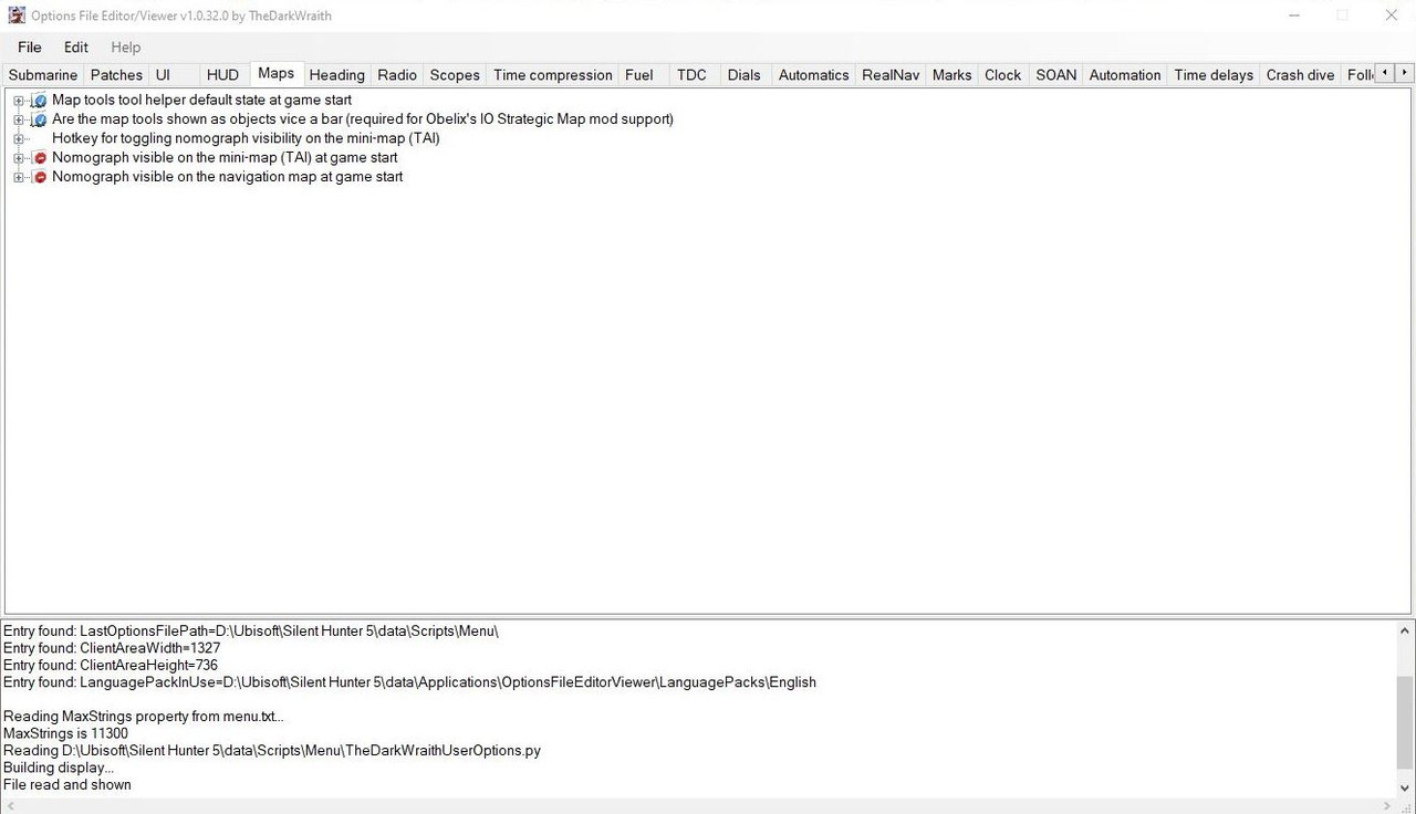 Peter
__________________
LSH3-2015 <> TUTORIALS <> ALL YOU NEED TO KNOW <> ALL IN ONE PLACE SH4 <> TUTORIALS <> HOW TO DO IT <> INFORMATION <> DOWNLOAD LINKS SH5 <> TUTORIALS <> HOW TO DO IT <> INFORMATION <> DOWNLOAD LINKS Always Here To Help A Fellow 'Subber' | Need An Answer to A Question Just Send Me A PM |
|
|
|
|
02-08-20, 10:39 AM
|
#6 |
|
Watch
Join Date: Jan 2020
Posts: 21
Downloads: 9
Uploads: 0
|
 is High Contrast Nav Map With Inverse Shallow Colour By Nisgeis> A Selection Of Different Navigation Map Options To Choose From > Enable JSGME compatible with TWOS pls? |
|
|
|
|
02-08-20, 10:41 AM
|
#7 |
|
Watch
Join Date: Jan 2020
Posts: 21
Downloads: 9
Uploads: 0
|
Is High Contrast Nav Map With Inverse Shallow Colour By Nisgeis> A Selection Of Different Navigation Map Options To Choose From > Enable JSGME compatible with TWOS pls?
|
|
|
|
|
02-08-20, 01:36 PM
|
#8 | ||
|
Navy Seal
Join Date: May 2010
Location: Србија
Posts: 6,078
Downloads: 581
Uploads: 13
|
Quote:
Quote:
__________________
Best regards... Vecko The Wolves of Steel v2.2.25_SH5 Expansion Pack_Full The Wolves of Steel v2.2.xx to v2.2.25 - Update PDF Install Instructions How to report an issue If You wish to support my work... |
||
|
|
|
|
02-08-20, 02:03 PM
|
#9 | |
|
Growing Old Disgracefully
Join Date: Dec 2012
Location: Dibden Purlieu - Southampton
Posts: 9,605
Downloads: 1123
Uploads: 0
|
Hi s
Quote:
Peter
__________________
LSH3-2015 <> TUTORIALS <> ALL YOU NEED TO KNOW <> ALL IN ONE PLACE SH4 <> TUTORIALS <> HOW TO DO IT <> INFORMATION <> DOWNLOAD LINKS SH5 <> TUTORIALS <> HOW TO DO IT <> INFORMATION <> DOWNLOAD LINKS Always Here To Help A Fellow 'Subber' | Need An Answer to A Question Just Send Me A PM |
|
|
|
|
|
02-28-20, 11:50 PM
|
#10 |
|
Planesman
 Join Date: Apr 2013
Location: uk.
Posts: 181
Downloads: 2368
Uploads: 0
|
 In respect of the mod mentioned, I installed it with JSGME, however it offered no options in choice of map (supposedly choice of 4) and though installed it did nothing to change current TWOS set map at all. In respect of the mod mentioned, I installed it with JSGME, however it offered no options in choice of map (supposedly choice of 4) and though installed it did nothing to change current TWOS set map at all.I seem to remember previously that there was a choice under data file.
__________________
   The objective of every dedicated Captain must be to anticipate problems and move swiftly to eradicate them. However, it's somewhat difficult to remember that your initial objective was to drain the swamp, when you are up to your ass in alligators!. |
|
|
|
 |
|
|


 Linear Mode

