
|
|
SUBSIM: The Web's #1 resource for all submarine & naval simulations since 1997
|
SUBSIM: The Web's #1 resource for all submarine & naval simulations since 1997 |
 01-06-17, 07:10 AM
|
#1 |
|
Girt by Sea

Join Date: Mar 2015
Location: Red Route 1
Posts: 363
Downloads: 131
Uploads: 34

|
I finally got around to uploading some of my 'best' maps, guys. It's up on the 'Maps and Missions' section of the Downloads page.
Here are some maps I've made for Dangerous Waters. There are eighteen for you to enjoy. They are essentially 'blank' of triggers, scripts, ships and submarines, for you to make your own missions. All landmarks, features, and EEZ boundaries are marked as accurately as possible. Research Credits go to Wikipedia, Vector Globe Atlas, US policy releases, searates.com (for major ports) and marineregions.org (for EEZs), various news websites, and computer game manuals. All information was accessed from publically available sources. The maps are: Yemen, Kola Peninsula, East China Sea, South China Sea, Spratley Islands, Libya, Bougainville, Persian Gulf, The East Australian Exercise Area (EAXA), Cuba, Greenland-Iceland Gap, Iceland-UK Gap, North Atlantic, Syria, Timor Sea, Black Sea, Baltic Sea and Adriatic Sea. Disclaimer: Naturally, download at your own risk. I take no responsibility for any adverse effects to your computer by downloading these files. Feedback (and requests) welcome via the Subsim forums! Here is a pic of my EAXA Map - the East Australian Exercise Area - Australia's premier east-coast air and naval ranges 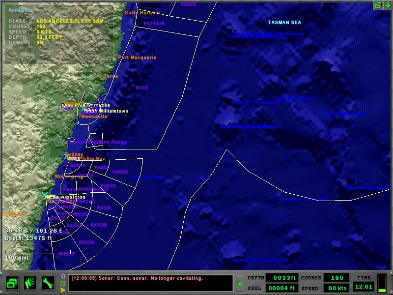 ...And here is my Persian Gulf Map 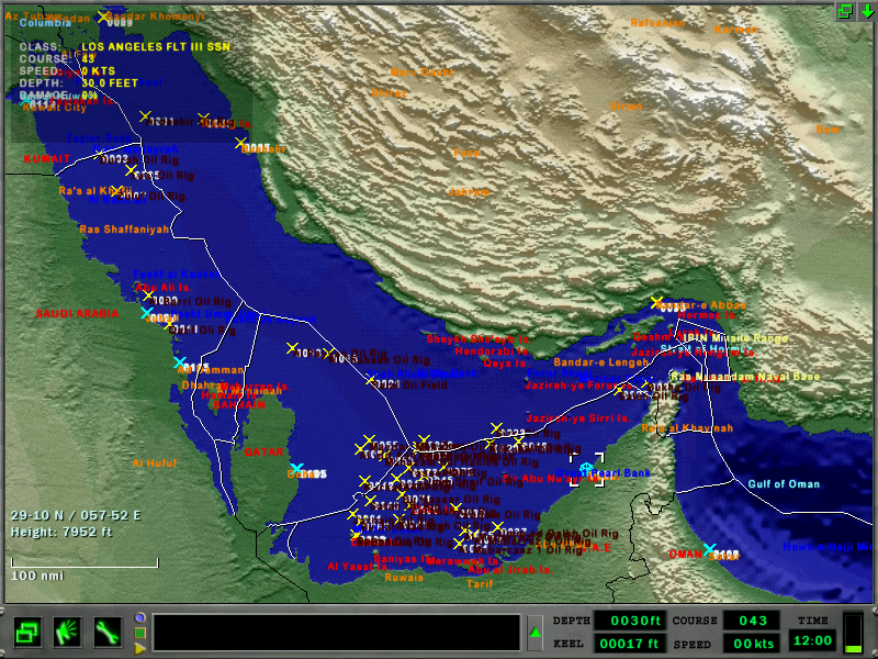 Enjoy! Last edited by Stewy1; 01-06-17 at 07:25 AM. |

|

|
|
01-20-17, 12:35 PM
|
#2 |
|
Stowaway
Posts: n/a
Downloads:
Uploads:
|
Outstanding!
|
|
|
|
01-22-17, 07:11 PM
|
#3 |
|
Stowaway
Posts: n/a
Downloads:
Uploads:
|
Would you consider doing some areas of the US coasts? San Diego and Groton areas come to mind. There sure are some navy training areas that could find use in scenarios... Hint hint...
|
|
|
|
01-25-17, 05:10 AM
|
#4 |
|
Girt by Sea
Join Date: Mar 2015
Location: Red Route 1
Posts: 363
Downloads: 131
Uploads: 34
|
I'm working on the SOCAL Training Range as we speak, mate. I've got about 1/2 of the ranges marked (all by guesses from .pdf published maps - not hard coordinates (I don't know how to find them)). I've already got the bathymetric features marked, and major cities. I just need to mark the EEZ boundary and finish the ranges.
I'd also like to do the Hawaii training ranges in another map.  If any Americans can help with finding the coordinates of the ranges (Australian ranges are published by the civil aviation authority), I'd really appreciate it - it'd make map making easier, quicker and more accurate. Map Pack 2.0 is in the pipeline as we speak. |
|
|
|
|
01-25-17, 10:16 AM
|
#5 |
|
Stowaway
Posts: n/a
Downloads:
Uploads:
|
Nice!
In my opinion, a well designed map adds a lot to a mission, especially the eez's and some land/water marks. Hope you find the info you need - I have no clue about any of this so I can't help at all. Looking forward to v2! |
|
|
|
01-31-17, 05:59 PM
|
#6 |
|
Girt by Sea
Join Date: Mar 2015
Location: Red Route 1
Posts: 363
Downloads: 131
Uploads: 34
|
Just an update on Map Pack 2, boys.
Sadly, my SOCAL map is dying - it's impossible to find the coordinates of the ranges without being in the know (Navy, US pilot, etc.) - I'm not happy with the accuracy of the ranges and with 'measuring' the coordinates with pencil and ruler, the accuracy isn't great and the ranges just don't 'look right' ...but...the good news is that you're being transferred! Coming in the next week or two will be more maps - and the Virginia Capes Range Complex!  Welcome to LANT!
|
|
|
|
|
01-31-17, 06:43 PM
|
#7 | |
|
Stowaway
Posts: n/a
Downloads:
Uploads:
|
Quote:
Perfect as I am working on a mission in the vacated opera, maybe even a pack. Your template would be very welcome! |
|
|
|
|
04-22-17, 01:35 PM
|
#8 |
|
Stowaway
Posts: n/a
Downloads:
Uploads:
|
Any news?
|
|
|
|
04-24-17, 04:50 AM
|
#9 |
|
Girt by Sea
Join Date: Mar 2015
Location: Red Route 1
Posts: 363
Downloads: 131
Uploads: 34
|
Hey Nip,
Thanks for the interest. Here's a bit of an update. The God of DW, FPSChazly, kindly made a program for me which coverts decimal lat/long coordinates into data that can easily be pasted into a mission .txt file - so marking EEZs takes about one tenth of the time that it used to and is hyper-accurate. He's been working on updating the program so that it can also covert deg/min/sec coordinates into the same DW mission format - but, by his own admission, he's pretty heavily into ArmA III (and who can blame him??) so the update has been delayed a little. I can finish the Virginia Capes map by hand - it'll just take a little longer - I'll try and make some progress over the next week or two. It's by far the most detailed map I've done. If that's not a priority - I can release a number of other maps that I've made since Map Pack 1 - including updated maps (like Syria, which now has the official Russian operating areas for both the Kuznetsov carrier and Peter the Great cruiser deployments - sadly, the airbase which Trump hit with Tomahawks is too high to map in DW  but they're marked anyway) but they're marked anyway)Thanks for your interest and support, Nip - I appreciate it, mate. Stew |
|
|
|
|
04-24-17, 07:28 AM
|
#10 |
|
Stowaway
Posts: n/a
Downloads:
Uploads:
|
Wow that's awesome, except for chazly being lazy as always....... ;D
If you soon have means to automate work on the vacapes, I'd say wait and safe the effort, really. Btw I released a P3 Orion mission last week where I included your template for the GIUK. So as you can see - your work is really appreciated! Now if the community would just be more... Alive. :/ |
|
|
|
04-24-17, 08:30 AM
|
#11 |
|
Good Hunting!

Join Date: Apr 2014
Location: Maryland
Posts: 771
Downloads: 15
Uploads: 1

|
 Yeah, yeah. I'm on it! haha Yeah, yeah. I'm on it! haha
__________________
Your friendly neighborhood modern submarine YouTuber. My videos: **Exclusive Look at Modern Naval Warfare!** Dangerous Waters Liu Doctrine (LwAmi Learn to play Dangerous Waters |
|
|
|
|
05-19-17, 10:40 PM
|
#12 |
|
Girt by Sea
Join Date: Mar 2015
Location: Red Route 1
Posts: 363
Downloads: 131
Uploads: 34
|
Hi everyone,
Thanks to Chazly's great plotting program, I've made a bit more progress on the Virginia Capes map. The northern range was done by hand, the southern range with Chazly's program. You can see the southern range looks much sharper (and done 90% quicker!)- I might delete and re-do the northern range with Chazly's program. I'm onto adding the Narragansett Bay ranges now (off Long Island). It's time consuming, but the end result is looking better and better! Thanks for your patience - it's getting there! Stew 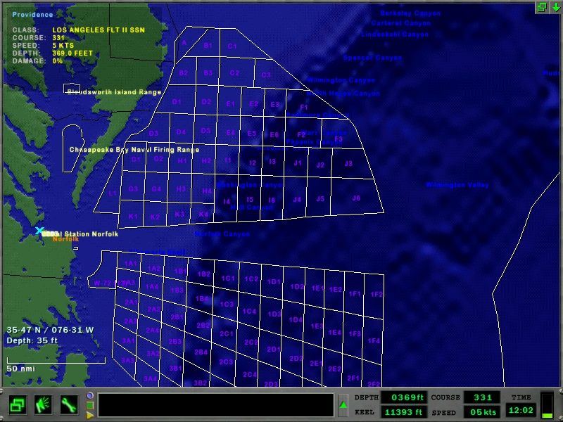
|
|
|
|
|
05-19-17, 10:43 PM
|
#13 |
|
Girt by Sea
Join Date: Mar 2015
Location: Red Route 1
Posts: 363
Downloads: 131
Uploads: 34
|
...also Nip, thanks for making that mission with my GIUK map (well, the 'GI' part of GIUK)
Chazly made a video of the mission - I was so proud to see my map in a real mission! 
|
|
|
|
|
05-19-17, 11:01 PM
|
#14 |
|
Stowaway
Posts: n/a
Downloads:
Uploads:
|
You nuts?
I gotta thank you for saving me hours of time creating a template for the area that wouldn't have been that detailed anyways, not remotely. And yeah a friend told me about his video(s). As I am mostly using mobile internet atm, I unfortunately didn't see it yet, but so far he made 2 videos and didn't kill a thing as far as I know... haha, chazly sucks at DW!   VACAPES looks great, I hope to create something with it some day, sure have an idea or two! By the way, I am working on multiple missions with your Cuba template as we speak and hope to release a mini-campaign soon. |
|
|
|
05-19-17, 11:48 PM
|
#15 |
|
Girt by Sea
Join Date: Mar 2015
Location: Red Route 1
Posts: 363
Downloads: 131
Uploads: 34
|
Thanks Nip - that sounds great - looking forward to a Cuba mission!
If you want to do some training missions on the Cuba map - I also have the AUTEC range marked in the Bahamas - the Tongue of the Ocean is deep! Now that I have Chazly's updated program, I can make steady progress on the Virginia Capes - I'll keep chipping away - it's a detailed map and there are a lot of ranges! If you're super keen for some naval exercise missions, feel free to make one 'down under' - My EAXA and WAXA naval ranges are already in the Map Packs!
|
|
|
|
 |
| Thread Tools | Search this Thread |
| Display Modes | |
|
|


 Linear Mode

