Hello,
I've made a first test with a route from Wilhelmshaven to somewhere near the Faroe Islands.
I think it works fine, but I cannot travel with a TC above 512. The game misses the next waypoint and Your sub goes straight ahead until You will stop it.

In the screenshot below You see, that I haven't started the route frome Wilhelmshaven. I have entered it from the Skagerrak. I went there with the Skagerrak-pilot from Kiel. I have activated the Marschweg-Autoscript and the sub found the nearest waypoint there and headed to NE.
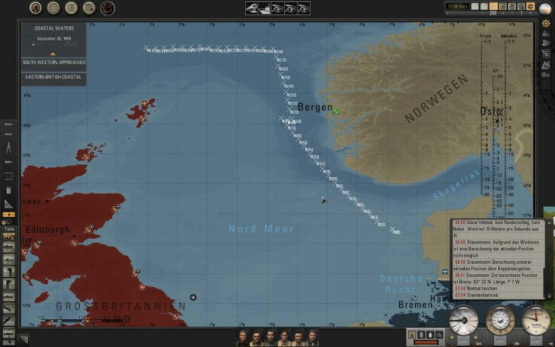
Near Bergen, I have travelled with TC 1024 and the Pilot missed the next WP. So I deactivated and reactivated the scipt on a low TC and it found the next one and resumed the given route.
The parameters for th sha-file are:
Code:
[TITLE]
Marschweg
[TITLE_END]
[DESCRIPTION]
Ihr Steuermann lässt das Boot auf diesem Weg in das befohlene Zielgebiet marschieren
[DESCRIPTION_END]
[PRECONDITION]
0,0,0
[PRECONDITION_END]
[WAYPOINT_RESUME]
50000
[WAYPOINT_RESUME_END]
[BUFFERZONE]
2000,0,2,3,1000,3,2,1
[BUFFERZONE_END]
[WAYPOINTRADIUS]
1000,2000
[WAYPOINTRADIUS_END]
980887,6427730,-1,9999,9999,9999,-1,Start
970000,6445000,-1,9999,9999,9999,-1,WP 1
960000,6500000,-1,9999,9999,9999,-1,WP 2
950000,6600000,-1,9999,9999,9999,-1,WP 3
920000,6700000,-1,9999,9999,9999,-1,WP 4
....
In my opinion the values are working fine, but perhaps there are some suggestions from Your side.

The testversion with this route:
http://www.mediafire.com/?5a768oo2o45j6br
Because it is dull to work with the Mission-Editor for finding the needed waypoints, I'll need some help from You

The game messures from
x-achse -21 600 000 metres to -21 600 000 -> 43 200 000 metres=pixel
and
y-achse -10 800 000 metres to -10 800 000. -> 21 600 000 metres=pixel
I have converted the large map file into a bmp file. But I got an ugly picture where I cant distinguish land from water. Perhaps someone could convert this file for me. I want to draw the lines in this picture for getting the x- and y-position ingame. I think the resolution from 1 pixel = 2000 m is exactly enough for defining the sub-routes.
If needed, I have an 80 MB PSD File from this map. Please PM me for the link.
Thanks,
Paco.